Loading...

🔥 End of Summer sale! 50% off on Supporter Accounts — now through September 1st. Learn More.

Slabcamp Run and Locust Spring Hike

Directions
Map
Pictures
Send to App
Distance:
8.8 Miles / 14.2 km
Type:
Loop
Difficulty:
Hard
Time to Hike:
4 hours, ~24 minutes
Features:
Surface Type:
Dirt
Park:
George Washington National Forest
Town:
Blue Grass, Virginia
Directions:
38.585757, -79.64267
Added:
February 17, 2025
Updated:
April 05, 2025
Guide by:
Copy Trail Link Hiking this trail? Send a friend or family member a link to this trail guide for your own safety. Hike at your own risk (disclaimer)
Loading...
Loading...
874'

Total Change
1,323'

Ascent
1,323'

Descent

Download the Trail Route for Offline Use

Supporters get exclusive access to download trail routes to the MyHikes app for offline use. Stay prepared on your adventure, even without an internet connection! Become a Supporter today to unlock this feature and hike with confidence.

Send to App

Slabcamp Run and Locust Spring Hike

The Slabcamp Run/Locust Spring circuit hike is part of the Laurel Fork wilderness area. Laurel Fork is one of the few very secluded backcountry forests left in Virginia. With high meadows, wetlands, and the fast running Laurel Fork on the valley floor, this has to be one of the best backpacks in the region.

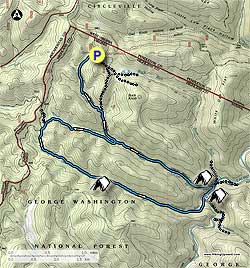
Trail Notes: All trails in the Laurel Fork area are blue blazed. In conjunction with the USDA Forest Service HikingUpward.com reblazed the Locust Spring Run, Locust Spring Run Spur, and Slabcamp Run trails in June 2007.

From the right bottom of the picnic area start down the the Locust Spring Run Trail as it heads through old growth forest for 1.2 miles before arriving at the Buck Run Connecter Trail. Turn right, cross the run, then immediately turn left downhill remaining on the blue blazed Locust Spring Run Trail. Cross over the run two more times before crossing a small side stream and passing an old wooden trail sign in 0.3 miles. In another 0.2 miles cross the run again and arrive at the intersection of the Locust Spring Run Spur Trail.

Turn right very steeply uphill on the Locust Spring Run Spur Trail for 100 yards, then stay right as the trail follows an old forestry road. Pass a beaver dam downhill on the right in 1.1 miles, and in another 0.1 miles turn left uphill following the blues blazes. In 0.1 miles arrive at the ridge, and intersection of the Slabcamp Run Trail and FS106.

Continue straight, through the closed gate onto the blue blazed Slabcamp Run Trail. The trail is 70 yards wide for the first 0.2 miles as it begins to descend the mountain. In 0.2 miles the trail veers slightly right, and in 0.1 miles arrives at a wetlands area on the right. Continue straight slightly uphill before following the trail on the right side of the clearing.

At this point the trail re-enters the forest as it follows Slabcamp Run on the left bank. Continue to follow the blue blazes as the trail descends towards Laurel Fork. In 1.0 miles from the wetlands clearing there is a large flat camping are on the banks of Slabcamp Run, suitable for several tents. As the trail continues towards the valley floor, and Laurel Fork, it will become considerably more rocky and crisscross the run several times. When the terrain levels out near the valley floor, the trail moves to the right bank of the run, then ends at Laurel Fork.

Ford Laurel Fork and in in 200 yards on the Laurel Fork Trail there is a large campsite. 250 yards past the campsite ford Laurel Fork for the last time, and in another 0.1 miles cross Locust Spring Run before arriving at the intersection of the Locust Spring Run Trail and another large camping area.

Turn left uphill on the blue blazed Locust Spring Run Trail as it heads upstream on the right bank of the run. At 1.3 miles the trail crosses the run and follows the left bank before arriving back at the intersection of the Locust Spring Run Spur Trail in another 0.2 miles.

Continue straight on the Locust Spring Run Trail re-crossing the run and retracing your steps back to the intersection of the Buck Run Connector Trail. Turn left staying on the Locust Spring Run Trail for the remaining 1.2 miles back to the Locust Spring Picnic Area.

Explore 37 trails near Blue Grass, VA
  1. Parking

    38.585757, -79.64267
  2. Main Trailhead

    38.584975, -79.641695
No community routes found. To add your own hike as a Community Route for this Trail guide, leave a Trip Report with an attached GPX file.

Hazards

Ticks - Lyme Disease More Info (CDC)
Snakes
Poison Ivy/Oak

Seasons

All

Blaze Color

Blue

Photo Albums

+ Add Photo Album

Upload your photos from the trail to help others know what to expect.

Trip Reports (Reviews)

Rated 2.88 out of 5 based on 8 ratings.
By: mrshwroberts
8.8 miles / 14.2 km
April 20, 2019
My husband and I chose this hike bc of the solitude rating. We weren't disappointed on that aspect. We only saw 2 people on their way out in the first two miles of the hike. It was a beautiful day and the first three miles or so were amazing with wildflowers blooming everywhere. The trail became difficult to follow once we reached the wetlands. It isn't marked frequently enough for the terrain, some trees with marks have fallen or lost the bark that had the mark, or new growth has covered the marks. Thanks to GPS we were able to get through this section without too much difficulty. The trail was better from that point until we got to where the trail crisscrosses Slabcamp Run. This is a rough section with some spots washed out. We finally made it to Laurel Fork only to discover that it was swollen and rushing. Even though the whole trail is supposed to be six hours, it took us six hours to get to this point. We made camp on that bank at an established camp site. We made the decision to hike up over the mountain to pick up the trail on the other side. It was quite a climb, but we picked up the trail along Locust Spring Run. We didn't have any difficulty on this part of the trail, but there were a lot of trees down across the trail. This trail is difficult bc it isn't used much. We had both GPS and topo maps. Don't do this trail without them. If you want to help with maintenance, take a pair of small limb cutters to cut back some of the pine limbs that have grown out to block the trail marks. We also recommend water shoes. I gave this hike 4 stars bc of the adventure factor!
Legacy Review
By: Kevin
8.8 miles / 14.2 km
August 04, 2018
This review deals mainly with Slabcamp Run. We hiked this trail as part of a two-nighter incorporating the Slabcamp/Locust Spring circuit with the Laurel Fork circuit, beginning our Slabcamp ordeal at its confluence with Laurel Fork late afternoon on our second day out. "Ordeal" is the right word. The trail is virtually non-existent. Blazes lower down are few and far between and what's left of the trail is overgrown with stinging nettles and blocked by downed trees. Mostly, we had to guess where the trail was headed and even for a group of five experienced hikers it took us over two and a half grueling hours to find our way up the 1.5 miles to the campsite. The campsite, on the left bank of Slabcamp, is far down off the trail on the stream, with no easy access, but it's a pleasant site. Just be careful getting to it and watch for poison ivy. The hike from the campsite to the Locust Spring trail was not quite as challenging, but we still had to use guess-work to find some of the next blazes. The trail pretty much disappears in the meadows and it takes some careful scouting to find the blazes and the trail, although the trail, while sketchy, at least exists for the most part. This is not a trail to attempt if you want to come away with good memories of this wilderness area. However, Buck Run/Locust Spring/Bearwallow/Laurel Fork are great (however, Laurel Fork between Bearwallow and Slabcamp presents its own challenges).
Legacy Review
By: Ken
8.8 miles / 14.2 km
September 17, 2016
The beginning of this hike along Locust Spring Run trail was very good. The trail was recently maintenanced and had easy to follow blue markings. Once you turn onto the Locust Sring Run Spur trail it gets bad. There were many downed trees across the trail and we missed the left turn going up to the intersection of FS 106 and Slabcamp Run Trail because we didn't see the blue trail blazes. Once we ended up on FS 106 we figured out were we were. But it got even worse once we turned onto Slabcamp Run trail. This trail was very overgrown and had many large trees down across it in the first part. Once we got into the clearing it was still hard to follow the trail because the blue markings were very spread out and things were overgrown. Once we reentered the forest, it was still very hard to follow the trail due to overgrowth and not seeing the blue blazes. When we finally got to the part where the trail follows the Slabcamp Run stream, the trail was washed out/missing in many places and was overgrown in Stinging Nettles plants everywhere else. We hiked the rocky stream bed for most of this section, thankfully it was almost dry. Once we got to Laurel Fork and forded it, the trail was in good shape again as you could see it was recently cut back. The camping area at the intersection of Locust Spring Run trail was very nice. I would recommend anyone wanting to hike this to only use the Locust Spring Run trail down to Laurel Fork as it appears to be in good shape right now. We returned to the picnic area on the Buck Run trail and it was in good shape with only a couple trees down blocking the trail.
Legacy Review

Weather Forecast

In Blue Grass, VA

Explore Hiking Trails

You May Also Like

New York's Best Waterfalls - Whether you're planning a day hike, roadside stop, or a leisurely short walk, this guide provides hikers, travelers, and locals alike with 63 different locations to over 100 scenic waterfalls to help plan your next adventure!
Explore

New York's Best Waterfalls

Whether you're planning a day hike, roadside stop, or a leisurely short walk, this guide provides hikers, travelers, and locals alike with 63 different locations to over 100 scenic waterfalls to help plan your next adventure!

Read
25 Best Day Hikes in North Carolina - Discover the top 25 best day hikes in North Carolina, from breathtaking waterfalls to mountain peaks. Explore hidden gems, scenic views, and trails suitable for all skill levels, perfect for your next outdoor adventure.
Explore

25 Best Day Hikes in North Carolina

Discover the top 25 best day hikes in North Carolina, from breathtaking waterfalls to mountain peaks. Explore hidden gems, scenic views, and trails suitable for all skill levels, perfect for your next outdoor adventure.

Read

Before you boogie...

Find our trail guides useful? Consider becoming a Supporter to unlock perks!

MyHikes is an indie platform that makes exploring public trails easier for everyone. The platform has no investors, no ads, and is owned and operated by one person, Dave Miller. Dave has personally mapped and written over 1,800 trail guides on MyHikes for the public to explore. MyHikes has helped millions outdoor enthusiasts plan their next adventure.

But it takes a lot of time 🕦, money 💰, work, and espresso shots ☕ to run MyHikes, including hiking , mapping , writing , and publishing new trails with high-quality (accurate) information... along with software engineering (coding) the platform like building new features, website and mobile app development (iOS and Android), site maintainance . and much much more.

Supporters unlock website and mobile app perks with an annual one-time payment of $25 (you renew) 😎👍. Or you can simply make a Donation of your choice. Otherwise, you can support us by telling your friends about MyHikes - both quick and free 🎉

Admin user profile picture

Dave Miller
MyHikes Founder