Loading...

WINTER SALE! 50% OFF Supporter Accounts — now through January 31st. Learn More.

Ski Slope Trail

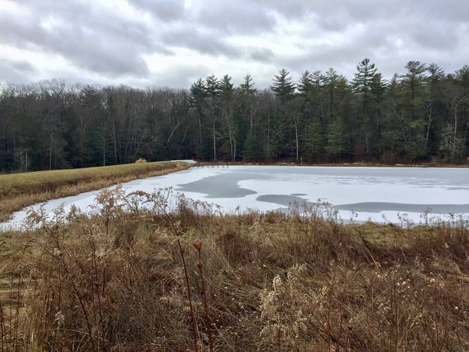
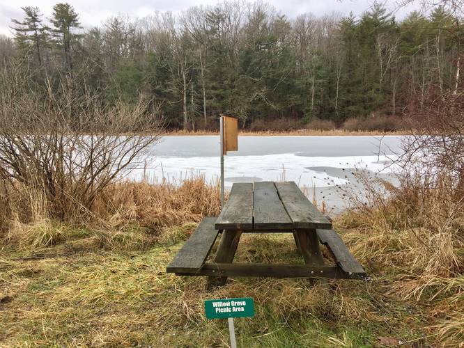
The Ski Slope Trail at Spencer Crest Nature Center in Corning, New York is an easy 0.3-mile one-way trail that features beautiful views of Amelia Pond and includes a picnic area next to the pond.

This recording begins at the eastern trailhead, located along Amelia Pond; however, hikers will also find the western trailhead located at the parking lot. If hiking in from the parking lot, hikers should look for the large propane tank next to a telephone pole - this is the trailhead, despite the lack of signage and the trail heads downhill from the parking lot and leads over to Amelia Pond.

If hiking this trail from Amelia Pond back to parking, the hike is pretty much the same, but a bit more difficult since you need to hike uphill back to parking. Despite the small uphill, this trail should be considered an easy difficulty rating.

Hikers will find a beautiful picnic area next to Amelia Pond and a multitude of birdhouses littered throughout the fields adjacent to the pond. The nature center's map labels a building named the "Milk House", but we did not see this structure along this trail.

Blaze Colors
This trail follows a double blazes of Red and White rectangular blazes.

Pets
Dogs are allowed if leashed and their waste must be carried out by the hiker.

Parking
Hikers can find parking at the main parking lot at Spencer Crest Nature Center - at the coordinates provided. The parking lot is large enough to fit a few dozen vehicles.
Explore 110 trails near Corning, NY

Know Before You Go

  • The Ski Slope Trail in Corning, NY is a short, easy 0.3-mile one-way trail with scenic views of Amelia Pond and a picnic area.
  • The trail has two trailheads, one near Amelia Pond and the other near the parking lot (marked by a propane tank).
  • Dogs are allowed on the trail if leashed, and waste must be carried out.
Interactive topographic map for Ski Slope Trail located in Corning, NY. Click the "View Map" button to load GPS coordinates and trail markers.
Get directions
Distance
0.3 mi
Difficulty
Easy
Type
One-Way
Est. Time
9 min
Elev. Gain
67'
Rating
0.0
Added
December 31, 2019
Updated
December 31, 2019

Weather Forecast

Overnight
Low 0°F
Mostly Cloudy
Saturday
High 12°F
Partly Sunny
Saturday Night
Low 6°F
Mostly Cloudy then Slight Chance Light Snow
Sunday
High 15°F
Heavy Snow
Sunday Night
Low 10°F
Heavy Snow
Monday
High 18°F
Snow then Chance Snow Showers
Monday Night
Low 2°F
Slight Chance Snow Showers then Mostly Cloudy
Tuesday
High 14°F
Partly Sunny
Tuesday Night
Low 2°F
Mostly Cloudy
Wednesday
High 17°F
Partly Sunny
Wednesday Night
Low 0°F
Mostly Cloudy then Slight Chance Snow Showers
Thursday
High 14°F
Slight Chance Snow Showers
Thursday Night
Low 2°F
Slight Chance Snow Showers then Mostly Cloudy
Friday
High 15°F
Mostly Cloudy
Loading...
Total Change
66'
Ascent
67'
Descent
6'
Loading...

Download the GPX Data for Offline Use

Supporters get exclusive access to download trail routes to the MyHikes app for offline use. Stay prepared on your adventure, even without an internet connection! Become a Supporter today to unlock this feature and hike with confidence.

Download Ski Slope Trail GPX Data to the MyHikes Mobile App

Features

Vista / Lookout Point
Dogs

Points of interest

  1. Parking

    42.116221, -77.083132
  2. Main Trailhead

    42.115487, -77.079124

Safety information

For your own safety: plan ahead, let someone know where you'll be, and hike at your own risk.

Markers

Blaze Color

Red

Blaze Dot Color

White

Availability

All seasons

Surface type

Dirt

Trip Reports (Reviews)

Your opinion matters! Be the first to rate this trail.

Ready to help fellow hikers? Add a trip report to share your experience and provide valuable insights for other hikers!

0.3 miles / 0.5 km
December 31, 2019
Dogs Hiking
No community routes found. To add your own hike as a Community Route for this Trail guide, leave a Trip Report with an attached GPX file.

Popular categories

Scenic mountain view representing vista trails
Vista trails
Scenic gorge of cascades representing waterfall trails
Waterfall hikes
Rugged mountain terrain representing summit trails
Summit trails
Scenic mountain view representing dog-friendly trails
Dog-friendly
Scenic campsite with a view representing camping trails
Camping trails
Appalachian Trail logo representing A.T. hikes
A.T. hikes

You May Also Like

Colorado's Million Dollar Highway - Plan a day's drive adventure along the iconic Million Dollar Highway in Colorado. Explore the best short trails, roadside stops, waterfalls, vistas, ghost towns, and hot springs within a ~6 hour road trip.
Explore

Colorado's Million Dollar Highway

Plan a day's drive adventure along the iconic Million Dollar Highway in Colorado. Explore the best short trails, roadside stops, waterfalls, vistas, ghost towns, and hot springs within a ~6 hour road trip.

Read
Glacier's Going-to-the-Sun Road - Discover the breathtaking beauty of Glacier National Park along the iconic Going-to-the-Sun Road. From stunning roadside stops to picturesque waterfalls and vistas, this engineering marvel offers endless opportunities for exploration.
Explore

Glacier's Going-to-the-Sun Road

Discover the breathtaking beauty of Glacier National Park along the iconic Going-to-the-Sun Road. From stunning roadside stops to picturesque waterfalls and vistas, this engineering marvel offers endless opportunities for exploration.

Read
🍪 We use cookies to learn about site usage and to serve map tiles. You may block cookies manually in the browser. By continuing you agree. Learn more