Loading...

🔥 End of Summer sale! 50% off on Supporter Accounts — now through September 1st. Learn More.

Shenandoah River State Park Hike

Directions
Map
Pictures
Send to App
Distance:
7.5 Miles / 12.1 km
Type:
Loop
Difficulty:
Moderate
Time to Hike:
3 hours, ~45 minutes
Features:
Surface Type:
Dirt
Town:
Bentonville, Virginia
Directions:
38.847816, -78.306023
Added:
April 03, 2025
Updated:
April 06, 2025
Guide by:
Copy Trail Link Hiking this trail? Send a friend or family member a link to this trail guide for your own safety. Hike at your own risk (disclaimer)
Loading...
Loading...
314'

Total Change
788'

Ascent
795'

Descent

Download the Trail Route for Offline Use

Supporters get exclusive access to download trail routes to the MyHikes app for offline use. Stay prepared on your adventure, even without an internet connection! Become a Supporter today to unlock this feature and hike with confidence.

Send to App

Shenandoah River State Park Hike

Virginia State Parks are well known for their amenities and great trails, and the Shenandoah River Raymond R. "Andy" Guest Jr. State Park is no exception. The 1,600 acre park, which opened in 1999, has 17 trails making up 24 miles, a virtual labyrinth. The trails include a beautiful overlook of the river, as well as a pleasant field walk.

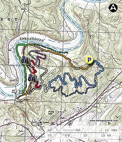
The 8.5 mile circuit hike we have mapped out here encompasses sections of the Bear Bottom Loop, Big Oak, Redtail Ridge, Shale Barrens, River, and Culler's Trails, passing 10 major intersections! But don't be concerned about getting lost, as the trail signage and tree blazing is excellent. Of note is that many trails are multiuse and are popular with mountain bikers and equestrians, so be prepared to share the trails.

Looking to make a weekend out of it? Even though we have camping rated as N/A as there is no camping on the trails, the park also has a picnic area with clean facilities, plus tent and trailer camping in designated areas.

  • Mile 0.0 - From the parking area at the Horse Barn enter the woods at the kiosk, then follow the trail for 75 yards to the Bear Bottom Loop Trail junction. Turn left on the blue blazed Bear Bottom Loop Trail where it slowly climbs a ridge to the intersection of the main Bear Bottom Loop in 0.8 miles.
  • Mile 0.9 - Turn right on the blue blazed Bear Bottom Loop Trail as it winds around the mountain for 1.9 miles to the intersection of the Big Oak Trail.
  • Mile 2.8 - Turn right onto the white blazed Big Oak Trail for 0.4 miles to the Shale Barrens Trail intersection.
  • Mile 3.2 - Stay right on the Big Oak trail for another 0.7 miles to the pink blazed Tulip Poplar Trail.
  • Mile 3.9 - Stay left on the white blazed Big Oak Trail for another 100 yards at which point the Big Oak trail turns right, and the red blazed Redtail Ridge Trail turns left.
  • Mile 4.0 - Turn left on the red blazed Redtail Ridge Trail for 0.2 miles to the out/back overlook trail. Take the short overlook trail to one of the best views of the Shenandoah River on the hike. Return to the Redtail Ridge Trail and continue for 0.4 miles passing another great view of the river through the trees. From this point it's another 0.5 miles to the intersection with the Shale Barrens Trail.
  • Mile 5.1 - Turn right downhill on the grey blazed Shale Barrens Trail for 0.4 miles to the Culler's Trail.
  • Mile 5.5 - Turn left on the orange blazed Culler's Trail for 0.2 miles to the intersection with the River Trail.
  • Mile 5.7 - Turn right on the dark green blazed River Trail for 0.4 miles to the next River Trail junction. Remain left on the River Trail passing a couple of nice benches before the trail turns left in 0.8 miles at a cabin and joining the Culler's Trail for 50 yards.
  • Mile 6.9 - Stay straight on the orange blazed Culler's Trail passing the white blazed Big Oak Trail in 0.2 miles, crossing a small creek, then arriving at a road crossing in another 0.6 miles.
  • Mile 7.7 - Cross the road remaining on the orange blazed Culler's Trail for the 0.8 miles back to the hike loop start point and intersection of the Bear Bottom Loop Trail.
  • Mile 8.5 - Turn left for the 75 yards back to the parking area.
Explore 95 trails near Bentonville, VA
  1. Parking

    38.847816, -78.306023
  2. Main Trailhead

    38.84793, -78.306084
No community routes found. To add your own hike as a Community Route for this Trail guide, leave a Trip Report with an attached GPX file.

Hazards

Ticks - Lyme Disease More Info (CDC)
Snakes
Poison Ivy/Oak

Seasons

All

Photo Albums

+ Add Photo Album

Upload your photos from the trail to help others know what to expect.

Trip Reports (Reviews)

Rated 4.0 out of 5 based on 9 ratings.
By: Lori
7.5 miles / 12.1 km
August 25, 2019
Wonderful hike! A gorgeous day (for late August) helped too. Worth the $10 parking fee. Plenty of parking in accessible lots. Also a visitor center with facilities. Trails very clearly marked. Pretty views, open fields. Like other reviews, not a lot of elevation, but makes up for it in distance especially if you add on a few miles with offshoot trails. A little worried about bears because they've been spotted, but none seen by me. Only passed mountain bikers-no other hikers. Close enough to Front Royal for gas and supplies on the way in or out of the park. Loved it!
Legacy Review
By: UnderDoug
7.5 miles / 12.1 km
February 03, 2018
This is one of my favorite parks in the Virginia system. The relatively flat terrain makes it a fantastic hike for those beginning to transition into longer day hikes. We were out with a group of Scouts, and everyone had a terrific time despite the cold weather. The trails at SRSP are among the most well marked and maintained trails I have ever hiked. Every trail is blazed in a different color, and every junction or intersection has a clearly marked (and color coded) sign post. There is no getting lost on this one. Fantastic park and fantastic hike!
Legacy Review
By: bns
7.5 miles / 12.1 km
January 29, 2017
This qualifies more as a stroll than a hike - I wouldn't put difficulty past a 2, and nearly all of it would qualify as a 1 - but it's a very serene area. I was on the trail before 9am and encountered only one other pair of hikers until I was returning to the parking lot. As others have mentioned, this route, which is cobbled together from a bunch of trails, is extremely well marked and easy to follow. My only suggestion would be to stick to the River Trail (dark green) after the cabin at the 5.7 mile instructions (also worth noting that there is currently a small pond over the trail just before the cabin, though you can pick your way off-trail around the edge) rather than staying on the orange-blazed Culler's trail. The River Trail would be more scenic and less multi-use than Culler's, which is really a gravel lane. I believe the River Trail breaks back off to the left after just a short bit on Culler's, and then rejoins Culler's just before you reach the 6.9 mile point where Culler's crosses a road. A couple of other notes: make sure to bring exact change for parking as the booth was unmanned (currently $7 during high season and for out-of-state $5 for in-state and off-season but up-to-date info is at http://www.dcr.virginia.gov/state-parks/shenandoah-river), and also worth sharing that this park would be great for cyclocrossers.
Legacy Review

Weather Forecast

In Bentonville, VA

Explore Hiking Trails

You May Also Like

New York's Best Waterfalls - Whether you're planning a day hike, roadside stop, or a leisurely short walk, this guide provides hikers, travelers, and locals alike with 63 different locations to over 100 scenic waterfalls to help plan your next adventure!
Explore

New York's Best Waterfalls

Whether you're planning a day hike, roadside stop, or a leisurely short walk, this guide provides hikers, travelers, and locals alike with 63 different locations to over 100 scenic waterfalls to help plan your next adventure!

Read
25 Best Day Hikes in North Carolina - Discover the top 25 best day hikes in North Carolina, from breathtaking waterfalls to mountain peaks. Explore hidden gems, scenic views, and trails suitable for all skill levels, perfect for your next outdoor adventure.
Explore

25 Best Day Hikes in North Carolina

Discover the top 25 best day hikes in North Carolina, from breathtaking waterfalls to mountain peaks. Explore hidden gems, scenic views, and trails suitable for all skill levels, perfect for your next outdoor adventure.

Read

Before you boogie...

Find our trail guides useful? Consider becoming a Supporter to unlock perks!

MyHikes is an indie platform that makes exploring public trails easier for everyone. The platform has no investors, no ads, and is owned and operated by one person, Dave Miller. Dave has personally mapped and written over 1,800 trail guides on MyHikes for the public to explore. MyHikes has helped millions outdoor enthusiasts plan their next adventure.

But it takes a lot of time 🕦, money 💰, work, and espresso shots ☕ to run MyHikes, including hiking , mapping , writing , and publishing new trails with high-quality (accurate) information... along with software engineering (coding) the platform like building new features, website and mobile app development (iOS and Android), site maintainance . and much much more.

Supporters unlock website and mobile app perks with an annual one-time payment of $25 (you renew) 😎👍. Or you can simply make a Donation of your choice. Otherwise, you can support us by telling your friends about MyHikes - both quick and free 🎉

Admin user profile picture

Dave Miller
MyHikes Founder