Loading...

🎉 Enjoy a Free 7-Day Supporter Trial and Unlock Exclusive Perks — No Credit Card Required. Learn more.

Shenandoah Mtn and Lynn Spring Hike

Directions
Map
Pictures
Send to App
Distance:
14.2 Miles / 22.9 km
Type:
Out-and-Back
Difficulty:
Moderate
Time to Hike:
7 hours, ~5 minutes
Features:
Surface Type:
Dirt
Park:
George Washington National Forest
Town:
West Augusta, Virginia
Directions:
38.311361, -79.383958
Added:
February 17, 2025
Updated:
April 05, 2025
Copy Trail Link Hiking this trail? Send a friend or family member a link to this trail guide for your own safety. Hike at your own risk (disclaimer)
Loading...
Loading...
833'

Total Change
2,198'

Ascent
2,198'

Descent

Download the Trail Route for Offline Use

Supporters get exclusive access to download trail routes to the MyHikes app for offline use. Stay prepared on your adventure, even without an internet connection! Become a Supporter today to unlock this feature and hike with confidence.

Send to App

Shenandoah Mtn and Lynn Spring Hike

Experience the beauty of the Ramsey's Draft Wilderness Area on one of the more remote trails in the region. Starting on the ridge at Fort Edward Johnson join the Shenandoah Mountain Trail as it winds its way along the ridge through flora including Lady Slippers, Mountain Laurel, and some of the last surviving Eastern Hemlocks in the George Washington National Forest. Other hikes in the area include Jerry's Run, the Shenandoah Mountain circuit, Ramsey's Draft, and Hardscrabble Knob.


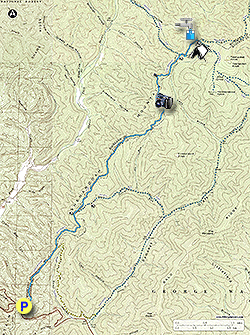
There are several excellent campsites on this out and back hike, and our favorite is at the intersection of the Shenandoah Mountain and Ramsey's Draft trails. This is also the hike turn around point and location of Lynn Spring. The spring is generally a reliable water source, but can reduce to a trickle if its been exceptionally dry for an extended period.

The short Confederate Breastworks interpretive loop trail is also located at Fort Edward Johnson. The fort was under the command of Brigadier General Edward Johnson during the Civil War, and was garrisoned by 3,000 Confederate soldiers of the 12th Georgia Regiment in 1862. The breastworks were located on the opposite side of US 250 and remnants are still visible.

  • Mile 0.0 - On the right side of the parking area next to the bathrooms and kiosk take the stairs upward on the Shenandoah Mountain Trail and soon pass a sign at the intersection of the Confederate Breastworks Trail. Stay right on the Shenandoah Mountain Trail as it works around the east side of the ridge. The trail is intermittently marked with yellow diamonds while outside the federal wilderness area.

  • Mile 0.25 - Pass another intersection with the Confederate Breastworks Trail on the left. Stay straight on the Shenandoah Mountain Trail.

  • Mile 1.35 - Arrive at the intersection with the Road Hollow Trail on the right. Stay straight continuing to follow the ridge on the Shenandoah Mountain Trail. There are intermittent views to the west through the trees. Pass a sign indicating you are entering the Ramsey's Draft Wilderness Area.

  • Mile 2.45 - Pass the intersection of the Jerry's Run Trail on the right remaining on the Shenandoah Mountain Trail. At this point the Shenandoah Mountain Trail descends slightly on the eastern side of the mountain before climbing and regaining the ridgeline. For the next 4.2 miles pass over several small knolls through intermittent stands of Eastern Hemlock. The Eastern Hemlock has been decimated over the past 15 years in Virginia by the Woolly Adelgid a sap sucking bug that kills the Hemlocks roots.

  • Mile 6.6 - Arrive at the intersection of the unmaintained Sinclair Hollow Trail. There is a nice campsite in the hollow before the intersection. Continue on the Shenandoah Mountain Trail climbing to the east around another knoll.

  • Mile 7.4 - Arrive a the main campsite and intersection of the Ramsey's Draft Trail. The campsite is large enough for multiple tents. Lynn Spring is located on the opposite side of the Shenandoah Mountain Trail from the campsite 40 yards downhill. This is the turn around point for this hike. To return retrace your route.

  • Mile 14.2 - Arrive back at US 250 and parking area at Fort Edward Jones Overlook.

Explore 32 trails near West Augusta, VA
  1. Parking

    38.311361, -79.383958
  2. Main Trailhead

    38.311361, -79.383958
No community routes found. To add your own hike as a Community Route for this Trail guide, leave a Trip Report with an attached GPX file.

Hazards

Ticks - Lyme Disease More Info (CDC)
Snakes
Poison Ivy/Oak

Seasons

All

Blaze Color

Blue

Trip Reports

Trail Guide By:
HikingUpward user profile picture
14.2 miles / 22.9 km

Weather Forecast

In West Augusta, VA

Explore Hiking Trails

You May Also Like

New York's Best Waterfalls - Whether you're planning a day hike, roadside stop, or a leisurely short walk, this guide provides hikers, travelers, and locals alike with 63 different locations to over 100 scenic waterfalls to help plan your next adventure!
Explore

New York's Best Waterfalls

Whether you're planning a day hike, roadside stop, or a leisurely short walk, this guide provides hikers, travelers, and locals alike with 63 different locations to over 100 scenic waterfalls to help plan your next adventure!

Read
25 Best Day Hikes in North Carolina - Discover the top 25 best day hikes in North Carolina, from breathtaking waterfalls to mountain peaks. Explore hidden gems, scenic views, and trails suitable for all skill levels, perfect for your next outdoor adventure.
Explore

25 Best Day Hikes in North Carolina

Discover the top 25 best day hikes in North Carolina, from breathtaking waterfalls to mountain peaks. Explore hidden gems, scenic views, and trails suitable for all skill levels, perfect for your next outdoor adventure.

Read

Before you boogie...

Find our trail guides useful? Consider becoming a Supporter to unlock perks!

MyHikes is an indie platform that makes exploring public trails easier for everyone. The platform has no investors, no ads, and is owned and operated by one person, Dave Miller. Dave has personally mapped and written over 1,800 trail guides on MyHikes for the public to explore. MyHikes has helped millions outdoor enthusiasts plan their next adventure.

But it takes a lot of time 🕦, money 💰, work, and espresso shots ☕ to run MyHikes, including hiking , mapping , writing , and publishing new trails with high-quality (accurate) information... along with software engineering (coding) the platform like building new features, website and mobile app development (iOS and Android), site maintainance . and much much more.

Supporters unlock website and mobile app perks with an annual one-time payment of $25 (you renew) 😎👍. Or you can simply make a Donation of your choice. Otherwise, you can support us by telling your friends about MyHikes - both quick and free 🎉

Admin user profile picture

Dave Miller
MyHikes Founder