The Shafer Canyon Overlook Trail at Canyonlands National Park near Moab, Utah is an easy 0.3-mile out-and-back popular hike that features stunning panoramic views of Shafer Canyon.
Hike Description
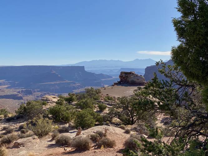
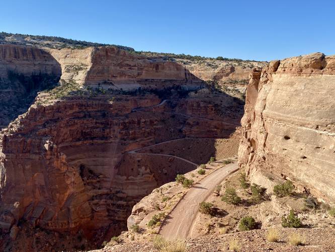
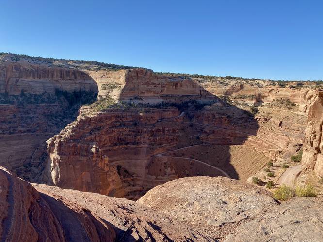
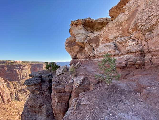
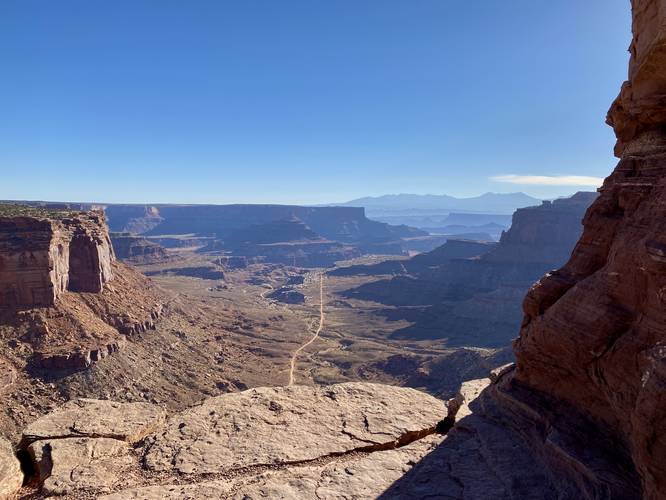
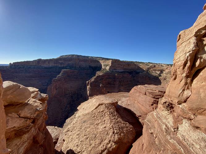
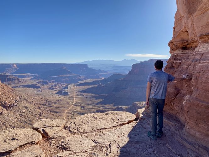
This hike begins at the main parking lot and trailhead for the Shafer Canyon Overlook Trail and follow the trail as it descends from the parking lot. Hikers will get beautiful views of Shafer Canyon on their way down the trail -- even the views from the parking lot are nice enough if you're unable to hike the trail. The trail follows rock steps as it leads downhill before the path opens up to views on all sides as hikers will follow the jutting rock point eastward to find more views. Along the way is an information kiosk about Shafer Canyon and the Shafer Trail (see the History section below for more details). Here, you'll get views facing southwest of the Shafer Trail as it winds its way down the 1,400-foot deep canyon. Hikers will head eastward to reach the end of the trail -- passing a very sketchy and steep cliff drop-off to the north side of the trail. Just beyond the sketchy cliff hike is the true end of the trail -- the Shafer Canyon Overlook. From the overlook, hikers will get stunning panoramic views of Shafer Canyon and into vast swaths of Canyonlands National Park's wilderness. Here, hikers can take-in the views and relax a bit before hiking back to parking.
Popularity
This trail is one of the most popular hikes at Canyonlands National Park and for good reason -- hikers get views throughout the entire hike and the views at the end of the trail are stunning.
History
Long ago, native people likely used this route (The Shafer Trail) to travel from the mesa to the Colorado River. In the early 1900s, ranchers drove livestock on it. Back then, the route was narrower and much more rugged. Animals sometimes slipped to their deaths. Imagine coaxing several hundred sheep along this path to find shelter in the canyons below or to graze in the grasslands above. The uranium boom in the 1950s changed the face of canyon country forever, beginning with the roads. The Shafer Trail was upgraded to accommodate trucks hauling mining equipment and ore. Abandoned mining roads can still be seen in narrow scars across the desert floor. After the establishment of Canyonlands National Park in 1964, the era of ranching and mining came to a close, but today's backcountry travelers owe their thanks to the pioneer of the Shafer Trail.
Parking
Hikers will find parking at the coordinates provided -- located at the end of the Shafer Canyon Overlook Road at Canyonlands National Park.
Pets
Dogs are not allowed on any trails at Canyonlands National Park. Please do not bring your dog here.
Warning
Sun exposure: This trail has very little shade and no water sources. Pack-in all water and wear sun screen and a hat to protect against sun exposure. It's smart to hike either in the early morning or late afternoon to avoid the intense desert sun.
No water: This trail has no water sources so you must pack-in all water. A general rule of thumb in the desert is 1 gallon of water per person per day.
Rattlesnakes: This is rattlesnake territory, so be on the lookout and give any rattlers you find plenty of space.
Steep cliffs: This trail follows steep cliffs. Watch your step and give yourself plenty of space from the edge of the cliffs for your own safety.
Fees
Vehicle entry fees to Canyonlands National Park is $30 as of September 2023.
Hike Description
This hike begins at the main parking lot and trailhead for the Shafer Canyon Overlook Trail and follow the trail as it descends from the parking lot. Hikers will get beautiful views of Shafer Canyon on their way down the trail -- even the views from the parking lot are nice enough if you're unable to hike the trail. The trail follows rock steps as it leads downhill before the path opens up to views on all sides as hikers will follow the jutting rock point eastward to find more views. Along the way is an information kiosk about Shafer Canyon and the Shafer Trail (see the History section below for more details). Here, you'll get views facing southwest of the Shafer Trail as it winds its way down the 1,400-foot deep canyon. Hikers will head eastward to reach the end of the trail -- passing a very sketchy and steep cliff drop-off to the north side of the trail. Just beyond the sketchy cliff hike is the true end of the trail -- the Shafer Canyon Overlook. From the overlook, hikers will get stunning panoramic views of Shafer Canyon and into vast swaths of Canyonlands National Park's wilderness. Here, hikers can take-in the views and relax a bit before hiking back to parking.
Popularity
This trail is one of the most popular hikes at Canyonlands National Park and for good reason -- hikers get views throughout the entire hike and the views at the end of the trail are stunning.
History
Long ago, native people likely used this route (The Shafer Trail) to travel from the mesa to the Colorado River. In the early 1900s, ranchers drove livestock on it. Back then, the route was narrower and much more rugged. Animals sometimes slipped to their deaths. Imagine coaxing several hundred sheep along this path to find shelter in the canyons below or to graze in the grasslands above. The uranium boom in the 1950s changed the face of canyon country forever, beginning with the roads. The Shafer Trail was upgraded to accommodate trucks hauling mining equipment and ore. Abandoned mining roads can still be seen in narrow scars across the desert floor. After the establishment of Canyonlands National Park in 1964, the era of ranching and mining came to a close, but today's backcountry travelers owe their thanks to the pioneer of the Shafer Trail.
Parking
Hikers will find parking at the coordinates provided -- located at the end of the Shafer Canyon Overlook Road at Canyonlands National Park.
Pets
Dogs are not allowed on any trails at Canyonlands National Park. Please do not bring your dog here.
Warning
Sun exposure: This trail has very little shade and no water sources. Pack-in all water and wear sun screen and a hat to protect against sun exposure. It's smart to hike either in the early morning or late afternoon to avoid the intense desert sun.
No water: This trail has no water sources so you must pack-in all water. A general rule of thumb in the desert is 1 gallon of water per person per day.
Rattlesnakes: This is rattlesnake territory, so be on the lookout and give any rattlers you find plenty of space.
Steep cliffs: This trail follows steep cliffs. Watch your step and give yourself plenty of space from the edge of the cliffs for your own safety.
Fees
Vehicle entry fees to Canyonlands National Park is $30 as of September 2023.