Loading...

WINTER SALE! 50% OFF Supporter Accounts — now through January 31st. Learn More.

Scott's Run Nature Preserve Hike

You won't find a closer waterfall hike to the Metro DC area. One mile from the beltway on Georgetown Pike, the Scott's Run Nature Preserve is a little piece of wilderness saved from urban sprawl. Originally the Burling Tract, it avoided development in the 1970's and was renamed the Dranesville District Park. Today it is known as the Scott's Run Nature Preserve.

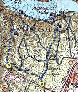
We have outlined a loop of 2.2 miles here, however the preserve has many interconnecting trails on its 384 acres. The Fairfax County Park Authority doesn't blaze or name any of the trails, but there is little chance of getting lost. You can't go any further north than the Potomac, and Georgetown Pike borders the property to the south. This hike has trails that range from the very easy to quite difficult.

Start down the path, and shortly cross a ford over Scott's Run then in 0.3 miles turn right crossing Scott's Run over the concrete posts. The path that leads straight, and didn't cross the run, takes the direct route down to the falls and becomes very difficult requiring boulder hopping. DO NOT take this route with children or when the trail is wet.

After crossing Scott's Run head uphill for 0.1 miles and junction of the wooden stairs that lead up to the Burling House Ruins. Turn left downhill for 0.1 miles to the Potomac River bank and falls where Scott's Run meets the river.

Turn right following the trail along the river bank and in 0.2 miles pass a small trail that leads uphill to the Burling House Ruins. In another 0.1 miles pass another trail that leads uphill. Continue along the riverbank where the trail goes around a small point. The point jetties out into the river here for about sixty feet and is a great spot for lunch. Twenty feet past the point take the trail as it heads directly uphill between two small ridges. As you pass the steepest section come to a minor trail junction.

Turn right, then immediately left along the top of the ridge spur and in 0.1 miles pass an old flag pole. Continue straight for another 0.2 miles an arrive at the next major trail junction (the trail to the right passes the Burling House Ruins then descends the wooden stairs and goes down to Scott's Run falls in the earlier part of this loop). Turn left and pass a four way junction in 0.1 miles.

In another 0.2 miles turn right at the next trail junction (if you arrive at the upper parking area and Georgetown Pike you've gone too far). Continue down the trail passing a trail on your right in 0.3 miles, then arriving back at the main parking area in another 0.2 miles.
Explore 19 trails near McLean, VA

Know Before You Go

  • Scott's Run Nature Preserve in McLean, VA offers a 2.4-mile loop hike near the DC Metro area, featuring a waterfall and varied terrain.
  • The preserve has multiple interconnecting trails across 384 acres, allowing for flexible exploration, but trails are not blazed or named.
  • The described hike includes a potentially difficult section with boulder hopping to the falls; an alternate route crossing Scott's Run via concrete posts is recommended, especially with children or when wet.
Interactive topographic map for Scott's Run Nature Preserve Hike located in McLean, VA. Click the "View Map" button to load GPS coordinates and trail markers.
Get directions
Distance
2.4 mi
Difficulty
Easy
Type
Loop
Est. Time
1.2 hrs
Elev. Gain
341'
Rating
3.9
Added
April 03, 2025
Updated
April 06, 2025

Weather Forecast

Loading...
Total Change
255'
Ascent
341'
Descent
339'
Loading...

Download the GPX Data for Offline Use

Supporters get exclusive access to download trail routes to the MyHikes app for offline use. Stay prepared on your adventure, even without an internet connection! Become a Supporter today to unlock this feature and hike with confidence.

Download Scott's Run Nature Preserve Hike GPX Data to the MyHikes Mobile App

Features

Vista / Lookout Point
Dogs
Waterfalls
Water Source

Points of interest

  1. Parking

    38.959472, -77.205052
  2. Main Trailhead

    38.959742, -77.205198

Safety information

For your own safety: plan ahead, let someone know where you'll be, and hike at your own risk.

Hazards

Poison Ivy or Poison Oak

Availability

All seasons

Surface type

Dirt

Trip Reports (Reviews)

Rated 3.87 out of 5 based on 38 ratings.

Ready to help fellow hikers? Add a trip report to share your experience and provide valuable insights for other hikers!

By: Justin V
2.4 miles / 3.9 km
January 26, 2017
Great DC area hike! If you are in DC definitely check it out, but I wouldnt travel to DC to do it. Lots of trails to choose from so took about 3 hours to check them all out. Few things: (1) people have mentioned a sewage smell, but other than maybe at the parking lot I didnt smell it at all. (2) Great place to hike with kids, dogs, but a few trails are more difficult than others (Order from easiest to hardest: Light blue/light green, purple, blue, red, yellow, orange). (3) pretty empty, but I did go on a work day. Here is a link to the trail map: http://i.imgur.com/ZrUFUbk.png . Top left is the trail map, top right (red) is what I walked, bottom left (yellow) is what this website recommends), bottom right (green) is what I think is a better hike.
Legacy Review
By: Adam R.
2.4 miles / 3.9 km
September 05, 2015
My wife and I took our four girls (ages 11 through 6) for a wonderful hike at Scott's Run this morning. The "sewage" smell was only faintly noticeable in the upper parking lot. We followed the route outlined here, working our way down to the falls. We'll need to remember swim gear next time so we can take a dip in the water! Instead of getting wet, we opted to climb the rocks far above the falls. The rocks were sheer at times, so thankfully no one slid down! We had lunch on the point and caught an osprey and heron having lunch out on the Potomac. The rest of the trail was uneventful, but pleasant. For a Saturday morning, the trails were populated, but not crowded. We'll definitely be going back to explore some of the other trails, especially the ruins which we weren't able to get to.
Legacy Review
By: northern va resident
2.4 miles / 3.9 km
May 03, 2015
The waterfall was pretty, but the entire hike all you smell is sewage. I would skip this hike in favor of great falls national park, just down the road. Believe me, of you want a jaw dropping hike, great falls is where it's at! For a Mediocre hike, come to scotts run. It's not how it used to be.
Legacy Review
No community routes found. To add your own hike as a Community Route for this Trail guide, leave a Trip Report with an attached GPX file.

Popular categories

Scenic mountain view representing vista trails
Vista trails
Scenic gorge of cascades representing waterfall trails
Waterfall hikes
Rugged mountain terrain representing summit trails
Summit trails
Scenic mountain view representing dog-friendly trails
Dog-friendly
Scenic campsite with a view representing camping trails
Camping trails
Appalachian Trail logo representing A.T. hikes
A.T. hikes

You May Also Like

25 Best Day Hikes in North Carolina - Discover the top 25 best day hikes in North Carolina, from breathtaking waterfalls to mountain peaks. Explore hidden gems, scenic views, and trails suitable for all skill levels, perfect for your next outdoor adventure.
Explore

25 Best Day Hikes in North Carolina

Discover the top 25 best day hikes in North Carolina, from breathtaking waterfalls to mountain peaks. Explore hidden gems, scenic views, and trails suitable for all skill levels, perfect for your next outdoor adventure.

Read
🍪 We use cookies to learn about site usage and to serve map tiles. You may block cookies manually in the browser. By continuing you agree. Learn more