Loading...

Distance:
0.1 Miles / 0.2 km
Type:
Out-and-Back
Difficulty:
Easy
Time to Hike:
~5 minutes
Features:
Surface Type:
Dirt
Park:
Hiawatha National Forest
Town:
Au Train, Michigan
Directions:
46.437053, -86.81475
Added:
September 25, 2022
Updated:
October 05, 2022
Loading...
Loading...
4 '

Total Change
4 '

Ascent
4 '

Descent

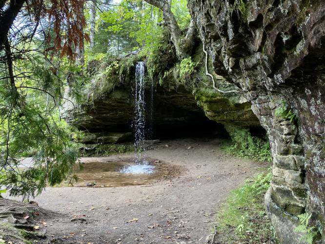
Scott Falls at Hiawatha National Forest in Au Train, Michigan is an easy 0.1-mile out-and-back walk that leads to the 10-foot tall free-falling waterfall, Scott Falls.

This is not a hike but rather a very short walk that leads a couple dozen feet from M-28 to the base of Scott Falls. Scott Falls cascades in a free-fall waterfall over a bedrock that features a small cave behind it. The best part about this waterfall is that it's extremely scenic despite being right on the highway, has a small cave to explore, and hikers can get up close to the base of the waterfall.

Parking
Hikers will find a parking turnout along M-28 in front of Scott Falls on the south side of the highway. The turnout is large enough to fit several vehicles, but cars can park down the highway if they wish.

Pets
Dogs are allowed if leashed and their waste must be carried out by the hiker.

Explore 10 trails near Au Train, MI
  1. Parking

    46.437053, -86.81475
  2. Main Trailhead

    46.437067, -86.814638
  3. Scott Falls, approx. 10-feet tall

    46.436986, -86.81457
    Scott Falls, approx. 10-feet tall
No community routes found. To add your own hike as a Community Route for this Trail guide, leave a Trip Report with an attached GPX file.

Hazards

Ticks - Lyme Disease More Info (CDC)

Seasons

All

Photo Albums

2 Trip Reports

No Star-Ratings
Trail Guide By:
Admin user profile picture
0.1 miles / 0.2 km
Trail added
September 25, 2022
Hiked on
September 21, 2022
Updated on
October 05, 2022
0.1 miles / 0.2 km
September 21, 2022
Hiking

Weather Forecast

In Au Train, MI

Explore Hiking Trails

New Hikes

Beaver Ponds Trail
0.1 Miles
0.2 km
Easy
Out-and-Back
Boulder Falls Trail
0.2 Miles
0.3 km
Moderate
Out-and-Back
Mary's Lake Trail
0.6 Miles
1 km
Easy
Out-and-Back
Many Parks Curve Trail
0.4 Miles
0.6 km
Easy
Out-and-Back

Before you boogie...

Find our trail guides useful? Consider becoming a Supporter to unlock perks!

MyHikes is an indie platform that makes exploring public trails easier for everyone. The platform has no investors, runs no ads, and is owned and operated by one person, Dave Miller. Dave has personally mapped and written over 1,600 trail guides on MyHikes for the public to explore. As of 2024, MyHikes has helped over 1,300,000 outdoor enthusiasts plan their next adventure.

But it takes a lot of time 🕦, money 💰, and work, and espresso shots ☕ to run MyHikes, including hiking , mapping , writing , and publishing new trails with high-quality (accurate) information... along with software engineering (coding) the platform like building new features, site and mobile app development for iOS and Android, site maintainance . and much much more.

Supporters unlock website and mobile app perks with an annual one-time payment of $25 (you renew) 😎👍. Or you can simply make a Donation of your choice. Otherwise, you can support us by telling your friends about MyHikes - both quick and free 🎉

Admin user profile picture

Dave Miller
MyHikes Founder