Sanderson Brook Falls at Chester-Blandford State Forest in Chester, Massachusetts is an easy 2-mile out-and-back hike that features the 60-foot tall waterfall, Sanderson Brook Falls.
Trails
This hike follows one named trail: Sanderson Brook Road. The hike also follows an unnamed spur trail that leads from Sanderson Brook Road down to the waterfall.
Hike Description
This hike begins at the main parking lot for Sanderson Brook Road, located at the parking coordinates provided on the south side of US-20 in Chester. The main trail is located at the southeast corner of the parking lot and heads south into the forest along an old wide road. This road is now closed to all motorized vehicles and hence is just a walking or biking path as of 2023. The trail follows a very gradual but uphill ascent as it heads further into the forest while passing three metal bridges along the way. Note that these metal bridges have large gaps, so if you're hiking with a dog it'll need to be picked-up from time to time to cross the bridges.
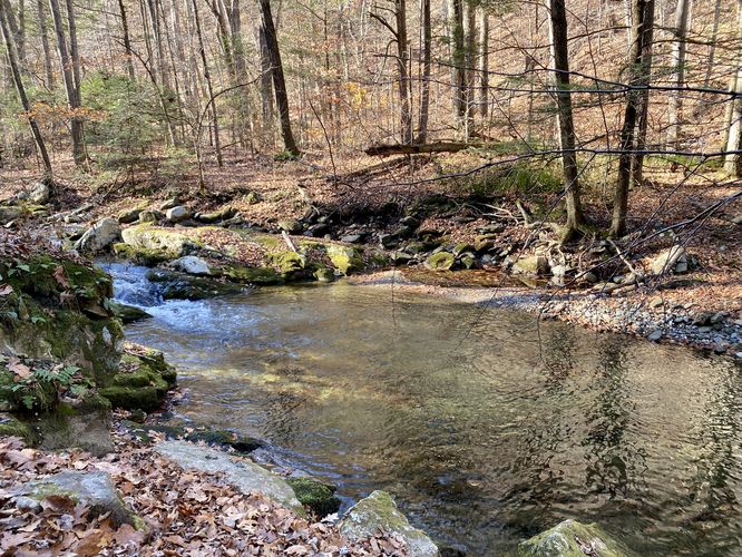
Swimming Hole - Mile 0.25
Around mile 0.25, hikers will find a deep swimming hole in Sanderson Brook below the trail. This is a great spot during Summer months to cool down, if you haven't already cooled down at Sanderson Brook Falls.
Turn to Sanderson Brook Falls - Mile 0.88
Around mile 0.88, hikers will reach a right-hand turn (hiking-in) that leads to Sanderson Brook Falls. You'll notice a small brown sign at the trailhead including a sign labeled "waterfall -->" on a nearby tree. Take this trail as it leads downhill to the base of Sanderson Brook Falls.
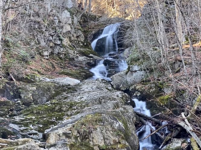
Sanderson Brook Falls - Mile 1
At mile 1, the trail will end at the base of the 60-foot tall multi-tiered waterfall known as Sanderson Brook Falls. The waterfall spills down the ledges and bedrock of the creek in a multitude of cascades to form the entire 60-foot waterfall. The view from below is impressive, but the best view is directly ahead on some large boulders that sit in the creek, just west of where the trail ends. During high water these boulders might be inaccessible, but on this hike, it was relatively dry to reach them. You can stand on these 4-foot tall boulders to get a better view of the waterfall. Note that due to the viewing location and bedrock placement, hikers cannot see the entire cascade from the base but you get to see a majority of them.
Hiking out from Sanderson Brook Falls is also relatively easy except for the initial hike out from the waterfall -- the hike out from the waterfall to Sanderson Brook Road is moderate at the worst. The hike out from the waterfall is all uphill for about 0.1-miles, but once back on Sanderson Brook Road, the hike out follows the gradual downhill road to reach parking for a 2-mile out-and-back hike.
Parking
Hikers will find a large parking lot at the coordinates provided, located along US-20 in Chester. The lot is large enough to fit over a dozen vehicles as of November 2023.
Pets
Dogs are allowed only if leashed and must be cleaned up after. Note that this hike includes three metal bridges where your dog will need to be helped across - likely carried entirely - to ensure they don't get hurt within the metal grates.
Warning
Timber Rattlesnakes: Massachusetts is home to the Timber Rattlesnake. While they're very rare to find in Massachusetts, they do roam the remote forests between the end of April to early October each year. Snakes will use the brooks to hunt prey or drink water. Be on the lookout and if you find any rattlers, give them plenty of space.
Trails
This hike follows one named trail: Sanderson Brook Road. The hike also follows an unnamed spur trail that leads from Sanderson Brook Road down to the waterfall.
Hike Description
This hike begins at the main parking lot for Sanderson Brook Road, located at the parking coordinates provided on the south side of US-20 in Chester. The main trail is located at the southeast corner of the parking lot and heads south into the forest along an old wide road. This road is now closed to all motorized vehicles and hence is just a walking or biking path as of 2023. The trail follows a very gradual but uphill ascent as it heads further into the forest while passing three metal bridges along the way. Note that these metal bridges have large gaps, so if you're hiking with a dog it'll need to be picked-up from time to time to cross the bridges.
Swimming Hole - Mile 0.25
Around mile 0.25, hikers will find a deep swimming hole in Sanderson Brook below the trail. This is a great spot during Summer months to cool down, if you haven't already cooled down at Sanderson Brook Falls.
Turn to Sanderson Brook Falls - Mile 0.88
Around mile 0.88, hikers will reach a right-hand turn (hiking-in) that leads to Sanderson Brook Falls. You'll notice a small brown sign at the trailhead including a sign labeled "waterfall -->" on a nearby tree. Take this trail as it leads downhill to the base of Sanderson Brook Falls.
Sanderson Brook Falls - Mile 1
At mile 1, the trail will end at the base of the 60-foot tall multi-tiered waterfall known as Sanderson Brook Falls. The waterfall spills down the ledges and bedrock of the creek in a multitude of cascades to form the entire 60-foot waterfall. The view from below is impressive, but the best view is directly ahead on some large boulders that sit in the creek, just west of where the trail ends. During high water these boulders might be inaccessible, but on this hike, it was relatively dry to reach them. You can stand on these 4-foot tall boulders to get a better view of the waterfall. Note that due to the viewing location and bedrock placement, hikers cannot see the entire cascade from the base but you get to see a majority of them.
Hiking out from Sanderson Brook Falls is also relatively easy except for the initial hike out from the waterfall -- the hike out from the waterfall to Sanderson Brook Road is moderate at the worst. The hike out from the waterfall is all uphill for about 0.1-miles, but once back on Sanderson Brook Road, the hike out follows the gradual downhill road to reach parking for a 2-mile out-and-back hike.
Parking
Hikers will find a large parking lot at the coordinates provided, located along US-20 in Chester. The lot is large enough to fit over a dozen vehicles as of November 2023.
Pets
Dogs are allowed only if leashed and must be cleaned up after. Note that this hike includes three metal bridges where your dog will need to be helped across - likely carried entirely - to ensure they don't get hurt within the metal grates.
Warning
Timber Rattlesnakes: Massachusetts is home to the Timber Rattlesnake. While they're very rare to find in Massachusetts, they do roam the remote forests between the end of April to early October each year. Snakes will use the brooks to hunt prey or drink water. Be on the lookout and if you find any rattlers, give them plenty of space.