Loading...

🔥 End of Summer sale! 50% off on Supporter Accounts — now through September 1st. Learn More.

Sand Flat via Salamander Trail Hike

Directions
Map
Pictures
Send to App
Distance:
8.9 Miles / 14.3 km
Type:
Loop
Difficulty:
Hard
Time to Hike:
4 hours, ~27 minutes
Features:
Surface Type:
Dirt
Town:
Frederick, Maryland
Directions:
39.561934, -77.498398
Added:
March 22, 2025
Updated:
April 06, 2025
Guide by:
Copy Trail Link Hiking this trail? Send a friend or family member a link to this trail guide for your own safety. Hike at your own risk (disclaimer)
Loading...
Loading...
513'

Total Change
1,058'

Ascent
1,058'

Descent

Download the Trail Route for Offline Use

Supporters get exclusive access to download trail routes to the MyHikes app for offline use. Stay prepared on your adventure, even without an internet connection! Become a Supporter today to unlock this feature and hike with confidence.

Send to App

Sand Flat via Salamander Trail Hike

This section of the Frederick Municipal Forest, just north of Gambrill State Park, is a virtual labyrinth of interconnecting trails. 
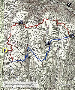
This circuit hike combines a section of the blue blazed Catoctin Trail, as well as the the Salamander Trail. The highlights are the two ponds on the Catoctin Trail, and the overlook near the junction of the Salamander Trail.

This area is also very popular with mountain bikers, with the Catoctin Trail having the highest density of our two wheeled friends. A map, and GPS are a must for this hike because of the number of interconnecting trails, especially on the Salamander Trail, where intersections show up every couple of hundred yards in places. Special thanks to Mike with www.midatlantichikes.com for recommending this circuit.

  • Mile 0.0 – Pass the closed gate and walk through a clearing, then pass a pond on the right and arrive at the first trail intersection.
  • Mile 0.2 - Turn right and and follow the trail to the next intersection in 0.2 miles.
  • Mile 0.4 - Stay left and in another 0.2 miles arrive at the intersection of the blue blazed Catoctin Trail.
  • Mile 0.6 - Turn left following the Catoctin Trail as it passes through several areas of Mountain Laurel and arrives at a four way intersection in another 0.2 miles.
  • Mile 0.8 - The old Catoctin Trail is to the right and blocked with blowdowns, directly ahead is the new section of the Catoctin Trail, and to the left is an unmarked trail. Stay straight on the new blue blazed Catoctin Trail. The blue blazed trail will switchback down the first ridge, pass through a section of fern, then cross a small stream before arriving at the next intersection in 1.3 miles.
  • Mile 2.1 - Turn right remaining on the Catoctin Trail and shortly cross a gravel road. Pass through the closed gate on the other side of the road and continue on the blue blazed Catoctin Trail for 0.9 miles to the next intersection.
  • Mile 3.0 - Turn left staying on the Catoctin Trail for 0.8 miles to the first of the two ponds.
  • Mile 3.8 - In 0.4 miles the the second pond will be on the left of the trail.
  • Mile 4.2 - From the second pond it's 0.3 miles to gravel Gambrill Park Rd. Cross the road then in 0.1 miles reach the intersection of the Salamander Trail. For now continue on the Catoctin Trail for 0.1 miles to the best view on the hike. Return to the intersection of the Salamander Trail.
  • Mile 4.8 - Turn right on the Salamander Trail north (this would have been a left turn on the Salamander Trail when you first past the intersection on the way to the overlook). Follow the Salamander Trail for 0.6 miles to the next intersection. This trail connects on the right and is easy to miss. If you do miss it you'll end up back on Gambrill Park Rd.
  • Mile 5.4 - Turn right and for the next 0.3 miles pass three more intersections. Use the map and GPS route to navigate. This section of the Salamander Trail is a labyrinth of small interconnecting paths.
  • Mile 5.7 - Intersection 12 on the GPS Track - Turn right on the less obvious trail. If you pass the 'Mo's Cut' sign you have missed the turn! In the next 1.6 miles pass 3 more intersections staying straight/right at each.
  • Mile 7.3 - Intersection 16 on the GPS Track - Turn right as the trail climbs past the Salamander Rock high point and arrives at a old stone house in another 0.3 miles.
  • Mile 7.6 - Turn right on the gravel road for 25 yards to the utility clear cut. Turn left down the utility clear cut for 0.2 miles at which point the trail veers left back into the forest. From the the clear cut to the next intersection it is less than 0.1 miles.
  • Mile 7.8 - Turn right at the intersection and follow the trail for another 0.7 miles passing two more minor intersections before reaching gravel Gambrill Park Rd.
  • Mile 8.5 - Turn right following Gambrill Park Rd. to a parking area and trailhead on the left in 0.1 miles.
  • Mile 8.6 - Turn left off Gambrill Park Rd. passing the closed gate and follow the trail for 0.2 miles to the next intersection. Be on the lookout for this trail intersection as it's easy to miss.
  • Mile 8.8- Turn right for 0.2 miles to the pond and beginning of the hike loop.
  • Mile 9.0 - Turn right following the connector trail back to the parking area in 0.2 miles
  • Mile 9.3 - Parking area.
Explore 27 trails near Frederick, MD
  1. Parking

    39.561934, -77.498398
  2. Main Trailhead

    39.561934, -77.498398
No community routes found. To add your own hike as a Community Route for this Trail guide, leave a Trip Report with an attached GPX file.

Hazards

Snakes
Poison Ivy/Oak

Seasons

All

Trip Reports (Reviews)

Rated 2.75 out of 5 based on 12 ratings.
By: Tim C.
8.9 miles / 14.3 km
January 18, 2019
Know this area well. Have hiked these trails many many times, thoroughly enjoy these woods. In the pictures there is an image of an old foundation. I'm very curious to know where this is? Is this in the Frederick watershed? If so how do I reach it?
Legacy Review
By: Paul
8.9 miles / 14.3 km
April 06, 2018
This is the third time I have hiked this hike. I'll emphasize this phrase that appears at the beginning of the description: "A map, and GPS are a must for this hike." I think a GPS is a must and I rely on it primarily. On the last half of the hike, after the overlook, there are no more blazes or trail markers at the many, many intersections. Even with a GPS I still get misrouted a few times, when the trail fades or where there is a fork with the options at a close angle to each other. This is after hiking it three times (I'm getting better). I get back on track by finding a GPS waypoint ahead of me and tracking directly to that which gets me back on the trail. (My "GPS" is an iPhone with the Earthmate app -- I think dedicated GPS device would be more accurate and keep me on track, but the iPhone is good enough for me.) Without a GPS, I think you can follow the map and description, and the blue blazes, to the overlook -- I would then turn back and not proceed if you don't have a GPS. I hope a some point the City of Frederick, the PATC, or someone else puts in a decent system of trail markers and blazes to make it more accessible to those not comfortable using a GPS. As this is my third time, I like this hike very much. For me it is a good combination of longer distance and signficant, but not too much, elevation change -- my favorite combination. The terrain and trails vary enough to be interesting. The overlook is nice -- it is the only "vista." On all three hikes I have seen no one else on the trails. This time when I arrived a few mountain bikers were returning. I saw mountain bike tracks along the entire hike.
Legacy Review
By: Greg & Mary
8.9 miles / 14.3 km
November 12, 2017
An enjoyable hike despite the absence of any trail blaze/markings on the Salamander Portion of this route. The few red tree blazes seemed to denote the boundary of the Frederick Municipal Water Shed rather than the Salamander trail. If we do this one again, we'll carry a can of red spray paint and a salamander stencil with us! We managed to navigate the route the old fashioned way (sans GPS) and had only one or two minor detours where we had to retrace our steps. FYI, the Moe's Cut sign is still there. We missed that turn by only 20 feet. I think hiking without the summer foliage in place helped us to successfully navigate the route. The only issue with the detailed trail guidance on this site is the following: Mile 8.6 - Turn left off Gambrill Park Rd. passing the closed gate and follow the trail for 0.2 miles to the next intersection. Be on the lookout for this trail intersection as it's easy to miss. Mile 8.8- Turn right for 0.2 miles to the pond and beginning of the hike loop. It is no more than 200 yards past the closed gate to the above referenced intersection and it is tough to spot.
Legacy Review

Weather Forecast

In Frederick, MD

Explore Hiking Trails

You May Also Like

Colorado's Million Dollar Highway - Plan a day's drive adventure along the iconic Million Dollar Highway in Colorado. Explore the best short trails, roadside stops, waterfalls, vistas, ghost towns, and hot springs within a ~6 hour road trip.
Explore

Colorado's Million Dollar Highway

Plan a day's drive adventure along the iconic Million Dollar Highway in Colorado. Explore the best short trails, roadside stops, waterfalls, vistas, ghost towns, and hot springs within a ~6 hour road trip.

Read
New York's Best Waterfalls - Whether you're planning a day hike, roadside stop, or a leisurely short walk, this guide provides hikers, travelers, and locals alike with 63 different locations to over 100 scenic waterfalls to help plan your next adventure!
Explore

New York's Best Waterfalls

Whether you're planning a day hike, roadside stop, or a leisurely short walk, this guide provides hikers, travelers, and locals alike with 63 different locations to over 100 scenic waterfalls to help plan your next adventure!

Read

Before you boogie...

Find our trail guides useful? Consider becoming a Supporter to unlock perks!

MyHikes is an indie platform that makes exploring public trails easier for everyone. The platform has no investors, no ads, and is owned and operated by one person, Dave Miller. Dave has personally mapped and written over 1,800 trail guides on MyHikes for the public to explore. MyHikes has helped millions outdoor enthusiasts plan their next adventure.

But it takes a lot of time 🕦, money 💰, work, and espresso shots ☕ to run MyHikes, including hiking , mapping , writing , and publishing new trails with high-quality (accurate) information... along with software engineering (coding) the platform like building new features, website and mobile app development (iOS and Android), site maintainance . and much much more.

Supporters unlock website and mobile app perks with an annual one-time payment of $25 (you renew) 😎👍. Or you can simply make a Donation of your choice. Otherwise, you can support us by telling your friends about MyHikes - both quick and free 🎉

Admin user profile picture

Dave Miller
MyHikes Founder