The Sand Dune & Broken Arches hike at Arches National Park near Moab, Utah is an easy 1.5-mile out-and-back hike that features two natural rock arch formations known as the Sand Dune Arch and the Broken Arch.
Trails
This hike follows two named trails: Sand Dune Arch Trail, Broken Arch Trail.
Hike Description
This hike begins at the main trailhead for the Sand Dune Arch Trail located at the coordinates provided. The first portion of this hike follows the Sand Dune Arch Trail as it leads into the desert before taking a right-hand turn toward the Sand Dune Arch. This section of the hike is by far the most interesting -- the trail leads into a rock "grotto" with towering cliffs overhead. The trail passes through a narrow passage where it ascends ~7-feet into a large echo chamber within the rock cliffs. Here, the trail switches to a sand substrate where walking is a bit more difficult.
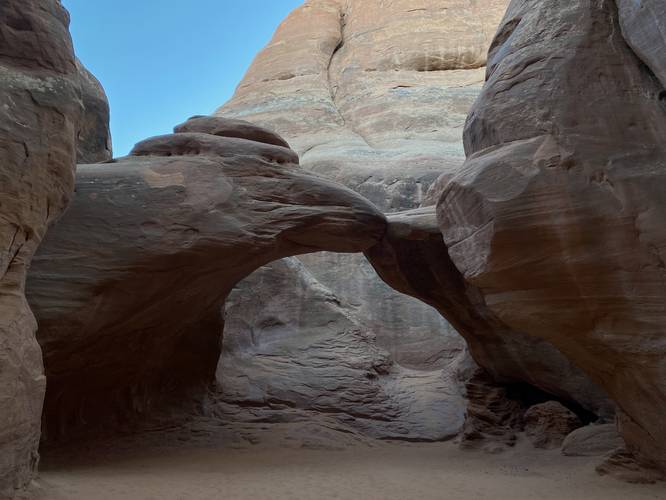
Sand Dune Arch - Mile 0.2
The trail then passes through another narrow passage between the cliffs to reach a view of the Sand Dune Arch right around the corner which is located around mile 0.2. Hikers can walk under the Sand Dune Arch, but the best view is set ~50-feet back where you'll get a neat view of the rock formation. This section of the hike reminded me of a desert level out of a Super Mario game where you transition from one landscape and into another -- this one was a dune and rock-filled world that felt like it existed on its own and separate from the rest of Arches National Park.
Hike to Broken Arch
After visiting the Sand Dune Arch, hikers will head northeast along the Broken Arch Connector Trail to reach a junction for the Broken Arch Trail at mile 0.6. The connector trail is mostly flat and easy to hike on with the exception of some sandy spots that slow down your speed a bit. At mile 0.6, take a right-hand turn to hike eastward to reach the Broken Arch.
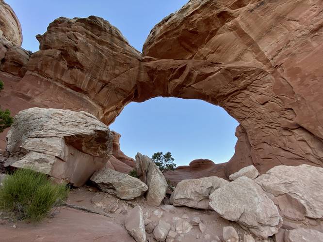
Broken Arch - Mile 0.85
Around mile 0.85, hikers will reach a view of the Broken Arch from the trail. If you wish to complete the loop (lollipop hike), then hikers will pass through Broken Arch to continue on the trail. We were hiking this during sunset, so we only had enough time to reach Broken Arch before hiking out; however, the view of Broken Arch is a nice change of pace from the darker cavern-like view of Sand Dune Arch. Hikers will find how it got its name -- it appears as though the arch is broken with a large crack down the top-center of the arch.
After visiting Broken Arch, this track leads hikers back to parking for a 1.5-mile out-and-back hike.
How to Get Into Arches National Park
Note that Arches National Park, as of September 2023 (and earlier) only allows vehicles to enter the park during scheduled time slots. You can read all about Arches' timed entry here and you can find reservation information here. Reservations are grabbed quickly, so be sure to log onto the reservation website when the date opens up to grab your timed entry ticket. Note that vehicles can enter the park outside of the timed entry slots (i.e. before 7AM or after 4PM each day, as of September 2023). If you do not have a timed entry ticket between 7AM and 4PM, do not wait in line to enter the park as you will be turned away and will slow everyone else down. The vehicle line to enter the park is very long and wait-times to enter can be a pain so show up prepared.
Parking
Hikers will find a large parking lot at the coordinates provided along Main Park Road in Arches National Park. The lot is large enough to fit a couple dozen vehicles, as of September 2023.
Pets
Dogs are not allowed on any trails at Arches National Park. Please do not bring your dog here.
Fees
As of September 2023, there's a $30 fee per vehicle to enter Arches National Park.
Warnings
Sun exposure: This trail has very little shade and no water sources. Pack-in all water and wear sun screen and a hat to protect against sun exposure. It's smart to hike either in the early morning or late afternoon to avoid the intense desert sun.
No water: This trail has no water sources so you must pack-in all water. A general rule of thumb in the desert is 1 gallon of water per person per day.
Rattlesnakes: This is rattlesnake territory, so be on the lookout and give any rattlers you find plenty of space.
Rockfall: This trail passes under large rock cliffs, some of which may have rockfall activity at random times.
Trails
This hike follows two named trails: Sand Dune Arch Trail, Broken Arch Trail.
Hike Description
This hike begins at the main trailhead for the Sand Dune Arch Trail located at the coordinates provided. The first portion of this hike follows the Sand Dune Arch Trail as it leads into the desert before taking a right-hand turn toward the Sand Dune Arch. This section of the hike is by far the most interesting -- the trail leads into a rock "grotto" with towering cliffs overhead. The trail passes through a narrow passage where it ascends ~7-feet into a large echo chamber within the rock cliffs. Here, the trail switches to a sand substrate where walking is a bit more difficult.
Sand Dune Arch - Mile 0.2
The trail then passes through another narrow passage between the cliffs to reach a view of the Sand Dune Arch right around the corner which is located around mile 0.2. Hikers can walk under the Sand Dune Arch, but the best view is set ~50-feet back where you'll get a neat view of the rock formation. This section of the hike reminded me of a desert level out of a Super Mario game where you transition from one landscape and into another -- this one was a dune and rock-filled world that felt like it existed on its own and separate from the rest of Arches National Park.
Hike to Broken Arch
After visiting the Sand Dune Arch, hikers will head northeast along the Broken Arch Connector Trail to reach a junction for the Broken Arch Trail at mile 0.6. The connector trail is mostly flat and easy to hike on with the exception of some sandy spots that slow down your speed a bit. At mile 0.6, take a right-hand turn to hike eastward to reach the Broken Arch.
Broken Arch - Mile 0.85
Around mile 0.85, hikers will reach a view of the Broken Arch from the trail. If you wish to complete the loop (lollipop hike), then hikers will pass through Broken Arch to continue on the trail. We were hiking this during sunset, so we only had enough time to reach Broken Arch before hiking out; however, the view of Broken Arch is a nice change of pace from the darker cavern-like view of Sand Dune Arch. Hikers will find how it got its name -- it appears as though the arch is broken with a large crack down the top-center of the arch.
After visiting Broken Arch, this track leads hikers back to parking for a 1.5-mile out-and-back hike.
How to Get Into Arches National Park
Note that Arches National Park, as of September 2023 (and earlier) only allows vehicles to enter the park during scheduled time slots. You can read all about Arches' timed entry here and you can find reservation information here. Reservations are grabbed quickly, so be sure to log onto the reservation website when the date opens up to grab your timed entry ticket. Note that vehicles can enter the park outside of the timed entry slots (i.e. before 7AM or after 4PM each day, as of September 2023). If you do not have a timed entry ticket between 7AM and 4PM, do not wait in line to enter the park as you will be turned away and will slow everyone else down. The vehicle line to enter the park is very long and wait-times to enter can be a pain so show up prepared.
Parking
Hikers will find a large parking lot at the coordinates provided along Main Park Road in Arches National Park. The lot is large enough to fit a couple dozen vehicles, as of September 2023.
Pets
Dogs are not allowed on any trails at Arches National Park. Please do not bring your dog here.
Fees
As of September 2023, there's a $30 fee per vehicle to enter Arches National Park.
Warnings
Sun exposure: This trail has very little shade and no water sources. Pack-in all water and wear sun screen and a hat to protect against sun exposure. It's smart to hike either in the early morning or late afternoon to avoid the intense desert sun.
No water: This trail has no water sources so you must pack-in all water. A general rule of thumb in the desert is 1 gallon of water per person per day.
Rattlesnakes: This is rattlesnake territory, so be on the lookout and give any rattlers you find plenty of space.
Rockfall: This trail passes under large rock cliffs, some of which may have rockfall activity at random times.