The Saluda Riverwalk in Columbia, South Carolina is an easy 1.2-mile out-and-back trail that features scenic views from the north shore of the Saluda River.
Walk
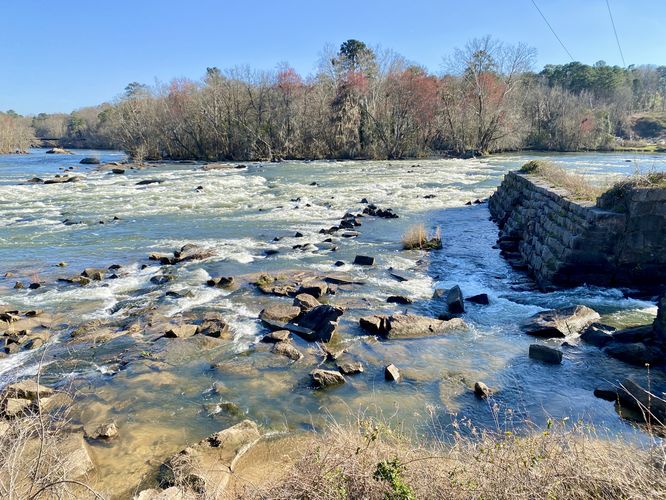
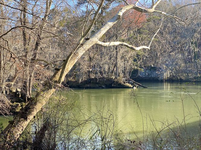
This is not a hike but rather a short out-and-back walk along a short portion of the longer Saluda Riverwalk pathway. The trailhead can be found on the east side of the main parking lot where the walk begins. The universally-accessible portion of the trail turns down low-grade switchbacks that lead downhill, but this recording heads straight down the stairs for a short-cut. Once you reach the bottom of the stairs, the trail heads over to the edge of the Saluda River where it follows alongside the river heading east and west. This track heads east to walk along the raised boardwalk. Walkers will also find rapids in the river here, which provides recreational opportunities for kayakers to test their skills against the strength of the river. You'll also find large boulders and stonework from earlier times that sit in the river and add to the scenery.
Raised Boardwalk - Mile 0.1 to 0.3
At mile 0.1, walkers will reach the Saluda River Boardwalk that spans the next 0.2-miles of trail. The boardwalk is raised above the river and provides views upstream and downstream near the rapids. This is probably the best part of the walk and the most scenic.
Off-trail Riverview - Mile 0.3
On the south side of the Saluda River Boardwalk is an off-trail view of the river where boulders sit along the banks. This off-trail spot provides a downstream view of the river.
Turn-Around & Old Saluda River Bridge Abutments - Mile 0.6
At mile 0.6, you'll walk under a bridge that crosses the river, connecting the botanical garden to the zoo. This GPS track ends here and heads back to parking; however, there's a historical sign on the south side of the overhanging brige about the Old Saluda River Bridge that once spanned the river here. If you look closer at the river you may spot the old stonework that lines the river's shores - both on the small island and on the far shoreline. These abutments are the foundations of the Old Saluda River Bridge.
The walk back to parking is an easy 0.6-mile jaunt to complete this short 1.2-mile out-and-back walk along the Saluda River.
Universally Accessible
As of March 2024, this trail is universally accessible. The trail follows a mostly paved surface, before following a wooden boardwalk that runs above the river, then follows a paved surface south of the boardwalk.
Parking
Walkers will find two large parking lots at the coordinates provided, located on the west side of Candi Lane in Columbia, SC. If the first parking lot is full, which fills up quickly, you'll find another larger parking lot located just north of the parking coordinates.
Pets
Dogs are allowed only if leashed and must be cleaned up after.
Warning
Flash flooding: Note that the Saluda River may have flash flooding. There's a nearby siren/horn that will blare in case of flood warnings. If you hear the siren, get off of the trail and find higher ground immediately just in case.
Walk
This is not a hike but rather a short out-and-back walk along a short portion of the longer Saluda Riverwalk pathway. The trailhead can be found on the east side of the main parking lot where the walk begins. The universally-accessible portion of the trail turns down low-grade switchbacks that lead downhill, but this recording heads straight down the stairs for a short-cut. Once you reach the bottom of the stairs, the trail heads over to the edge of the Saluda River where it follows alongside the river heading east and west. This track heads east to walk along the raised boardwalk. Walkers will also find rapids in the river here, which provides recreational opportunities for kayakers to test their skills against the strength of the river. You'll also find large boulders and stonework from earlier times that sit in the river and add to the scenery.
Raised Boardwalk - Mile 0.1 to 0.3
At mile 0.1, walkers will reach the Saluda River Boardwalk that spans the next 0.2-miles of trail. The boardwalk is raised above the river and provides views upstream and downstream near the rapids. This is probably the best part of the walk and the most scenic.
Off-trail Riverview - Mile 0.3
On the south side of the Saluda River Boardwalk is an off-trail view of the river where boulders sit along the banks. This off-trail spot provides a downstream view of the river.
Turn-Around & Old Saluda River Bridge Abutments - Mile 0.6
At mile 0.6, you'll walk under a bridge that crosses the river, connecting the botanical garden to the zoo. This GPS track ends here and heads back to parking; however, there's a historical sign on the south side of the overhanging brige about the Old Saluda River Bridge that once spanned the river here. If you look closer at the river you may spot the old stonework that lines the river's shores - both on the small island and on the far shoreline. These abutments are the foundations of the Old Saluda River Bridge.
The walk back to parking is an easy 0.6-mile jaunt to complete this short 1.2-mile out-and-back walk along the Saluda River.
Universally Accessible
As of March 2024, this trail is universally accessible. The trail follows a mostly paved surface, before following a wooden boardwalk that runs above the river, then follows a paved surface south of the boardwalk.
Parking
Walkers will find two large parking lots at the coordinates provided, located on the west side of Candi Lane in Columbia, SC. If the first parking lot is full, which fills up quickly, you'll find another larger parking lot located just north of the parking coordinates.
Pets
Dogs are allowed only if leashed and must be cleaned up after.
Warning
Flash flooding: Note that the Saluda River may have flash flooding. There's a nearby siren/horn that will blare in case of flood warnings. If you hear the siren, get off of the trail and find higher ground immediately just in case.