Loading...

๐ŸŽ† 50% off 4th of July sale on Supporter Accounts โ€” now through July 6! Learn More.

Saint Marguerite Island Loop (North)

Directions
Map
Pictures
Send to App
Distance:
2.6 km / 1.6 Miles
Type:
Loop
Difficulty:
Easy
Time to Hike:
~48 minutes
Features:
Surface Type:
Universal Access
Park:
Boucherville Islands National Park
Town:
Boucherville, Quebec - Canada
Directions:
45.597158, -73.47035
Added:
October 07, 2024
Updated:
December 19, 2024
Copy Trail Link Hiking this trail? Send a friend or family member a link to this trail guide for your own safety. Hike at your own risk (disclaimer)
Loading...
Loading...
9m

Total Change
9m

Ascent
11m

Descent

Download the Trail Route for Offline Use

Supporters get exclusive access to download trail routes to the MyHikes app for offline use. Stay prepared on your adventure, even without an internet connection! Become a Supporter today to unlock this feature and hike with confidence.

Send to App

Saint Marguerite Island Loop (North)

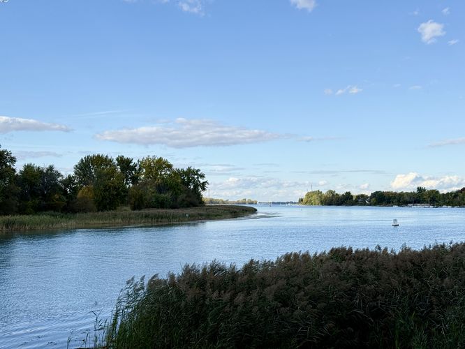
The Saint Marguerite Island Loop (North) at Boucherville Islands National Park in Boucherville, QC is an easy 2.5 km loop hike that leads to a viewpoint called The Bow (La Proue) along the Saint Lawrence River.

Hiking Saint Marguerite Island

This short hike begins at the second parking lot at the park, located near the visitors center. The Saint Marguerite Island Loop can be picked up at the parking lot from various trailhead locations. This route begins just east of the visitors center, passing the parking lot, and hops on the trail on the southeast side of the island. The route leads hikers north along the hiking-only footpath to reach La Proue (The Bow) viewpoint.

La Proue (The Bow) - 1.43 km

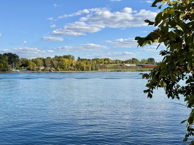
Around 1.43 km, hikers will reach La Proue with a northward view of the Saint Lawrence River and the buildings in north Boucherville. As of October 2024, there's a structure with a series of stairs which allows a multitude of visitors to sit and enjoy the scenery of the river.

After exploring La Proue, hikers can choose to loop back to parking by following this route, hike the entire island, or explore more trails at the park. For our adventure, we first hopped off of this trail and explored both the Grape Island Trail and the Island of the Commune Trail.

Parking & Fees

Visitors will find massive parking lots at the park. The coordinates provided lead to the 2nd largest parking lot, located near the visitors center. To enter the park, there's a $15 fee as of October 2024.

Pets

Dogs are allowed only if leashed and must be cleaned up after.

Universal Accessibility

Please note that this route is universally-accessible especially if you stay on the biking / stroller / accessible path that sits adjacent to the hiking-only trail. The islands generally include both a hiking-only and accessible trail that run side-by-side at least along the Saint Marguerite Island and Island of the Commune.
Explore 4 trails near Boucherville, QC
  1. Parking

    45.597158, -73.47035
  2. Main Trailhead

    45.597325, -73.470804
  3. View of the Saint Lawrence River

    45.598147, -73.464906
    View of the Saint Lawrence River
  4. View from La Proue (The Bow)

    45.604461, -73.462181
    View from La Proue (The Bow)
No community routes found. To add your own hike as a Community Route for this Trail guide, leave a Trip Report with an attached GPX file.

Seasons

All

Photo Albums

Trip Reports

Trail Guide By:
Admin user profile picture
1.6 miles / 2.6 km
1.6 miles / 2.6 km
October 05, 2024
We used this trail to connect to the other islands at the park with a stop at La Proue. Nice views of the Saint Lawrence River and easy walking.
Hiking

Weather Forecast

In Boucherville, QC

Explore Hiking Trails

You May Also Like

Colorado's Million Dollar Highway - Plan a day's drive adventure along the iconic Million Dollar Highway in Colorado. Explore the best short trails, roadside stops, waterfalls, vistas, ghost towns, and hot springs within a ~6 hour road trip.
Explore

Colorado's Million Dollar Highway

Plan a day's drive adventure along the iconic Million Dollar Highway in Colorado. Explore the best short trails, roadside stops, waterfalls, vistas, ghost towns, and hot springs within a ~6 hour road trip.

Read
Glacier's Going-to-the-Sun Road - Discover the breathtaking beauty of Glacier National Park along the iconic Going-to-the-Sun Road. From stunning roadside stops to picturesque waterfalls and vistas, this engineering marvel offers endless opportunities for exploration.
Explore

Glacier's Going-to-the-Sun Road

Discover the breathtaking beauty of Glacier National Park along the iconic Going-to-the-Sun Road. From stunning roadside stops to picturesque waterfalls and vistas, this engineering marvel offers endless opportunities for exploration.

Read
New York's Best Waterfalls - Whether you're planning a day hike, roadside stop, or a leisurely short walk, this guide provides hikers, travelers, and locals alike with 63 different locations to over 100 scenic waterfalls to help plan your next adventure!
Explore

New York's Best Waterfalls

Whether you're planning a day hike, roadside stop, or a leisurely short walk, this guide provides hikers, travelers, and locals alike with 63 different locations to over 100 scenic waterfalls to help plan your next adventure!

Read

Before you boogie...

Find our trail guides useful? Consider becoming a Supporter to unlock perks!

MyHikes is an indie platform that makes exploring public trails easier for everyone. The platform has no investors, no ads, and is owned and operated by one person, Dave Miller. Dave has personally mapped and written over 1,800 trail guides on MyHikes for the public to explore. MyHikes has helped millions outdoor enthusiasts plan their next adventure.

But it takes a lot of time ๐Ÿ•ฆ, money ๐Ÿ’ฐ, work, and espresso shots โ˜• to run MyHikes, including hiking , mapping , writing , and publishing new trails with high-quality (accurate) information... along with software engineering (coding) the platform like building new features, website and mobile app development (iOS and Android), site maintainance . and much much more.

Supporters unlock website and mobile app perks with an annual one-time payment of $25 (you renew) ๐Ÿ˜Ž๐Ÿ‘. Or you can simply make a Donation of your choice. Otherwise, you can support us by telling your friends about MyHikes - both quick and free ๐ŸŽ‰

Admin user profile picture

Dave Miller
MyHikes Founder