Loading...

๐ŸŽ† 50% off 4th of July sale on Supporter Accounts โ€” now through July 6! Learn More.

Ruby Beach Trail

Directions
Map
Pictures
Send to App
Distance:
0.6 Miles / 1.0 km
Type:
Out-and-Back
Difficulty:
Easy
Time to Hike:
~18 minutes
Features:
Surface Type:
Dirt
Park:
Olympic National Park
Town:
Hoh, Washington
Directions:
47.709841, -124.41378
Added:
June 16, 2025
Updated:
July 02, 2025
Copy Trail Link Hiking this trail? Send a friend or family member a link to this trail guide for your own safety. Hike at your own risk (disclaimer)
Loading...
Loading...
77'

Total Change
82'

Ascent
82'

Descent

Download the Trail Route for Offline Use

Supporters get exclusive access to download trail routes to the MyHikes app for offline use. Stay prepared on your adventure, even without an internet connection! Become a Supporter today to unlock this feature and hike with confidence.

Send to App

Ruby Beach Trail

The Ruby Beach Trail at Olympic National Park near is an easy 0.6-mile out-and-back hike that leads to views of Abbey Island and the sea stacks that dot the coastline.

Explore Olympic's Ruby Beach

This hike begins at the main parking lot for Ruby Beach and follows the well-maintained path as it leads down toward the beach. Along the way is at least one lookout point of the beach, Abbey Island, and the sea stacks, so if you're short on time or don't care to deal with the driftwood trees that line the beach, you can appreciate the views from the trail.

Following the trail further, it leads through short shrubs like Salmonberry and other native plants before the trail essentially ends at the beach. From the beach, you're on your own to explore and you should do so with caution. Note that Ruby Beach is littered with large, bare trees that often become stacked on top of each other due to the always-rising and falling tides. These driftwood trees can often roll and have been known to roll on to and crush hikers and visitors, often resulting in death. From the end of the trail, passing these driftwood trees, you must be careful and commit to exploring mostly at low tide when the trees are less-likely to roll over and crush you.

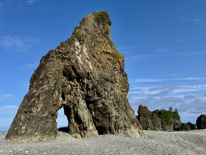
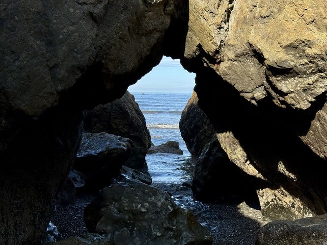
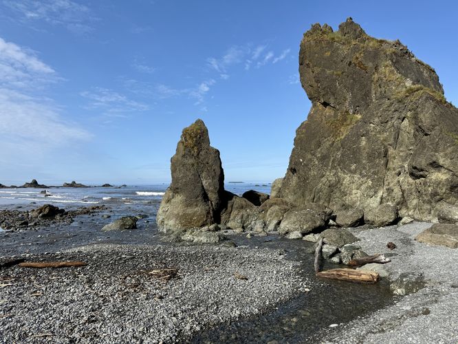
On the opposite side of the driftwood trees is where Ruby Beach's views really come into view. From here, you can hike up to the monolithic sea stacks that dot the beach's shoreline. These large rocks were shaped by the ocean, eroding them slowly over time. In many of the sea stacks, you'll find large holes that you can even walk through or simply take photos through as if they were portholes off of ships floating on the ocean.

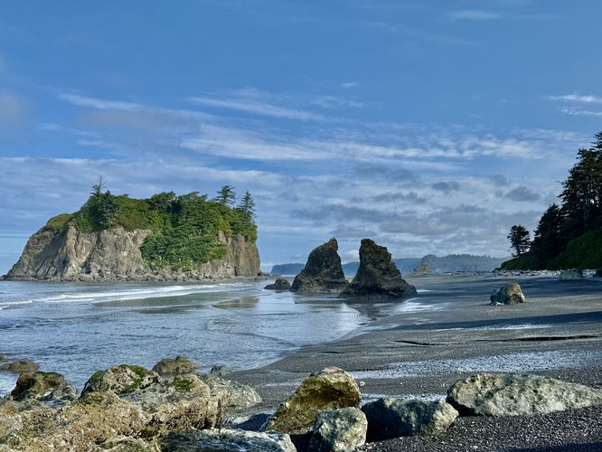
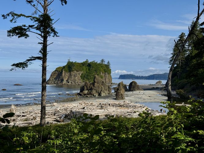
To the north sits Abbey Island which adorns a forest atop of its rocky outcropping. While there's no easy way (without climbing skills and gear) to reach the top of Abbey Island, the view of it from Ruby Beach is unmatched along Olympic's western coastline.

When you're done exploring what Ruby Beach has to offer, the trail leads back to the parking lot for an easy 0.6-mile out-and-back hike.

Parking

Hikers will find a large parking lot at the coordinates provided, located on the west side of US-101 south of Hoh, Washington. The lot is large enough to fit several dozen vehicles as of June 2025.

Warning

Driftwood trees: As stated earlier, the driftwood trees that line Ruby Beach can in fact be extremely dangerous, especially at high tide when the trees can and do move around. If you traverse the trees when there's water surrounding them, you take on chances that the trees could roll and fall onto you, ultimately crushing and killing you. It's best to explore Ruby Beach at low tide when the trees are essentially immovable. Note that it's best if you do not climb the trees but instead walk around them if you can. Hike at your own risk.
Explore 5 trails near Hoh, WA
  1. Parking

    47.709841, -124.41378
  2. Main Trailhead

    47.709841, -124.41378
  3. Sea stack with a hole in it

    47.711211, -124.415803
    Sea stack with a hole in it
  4. More sea stack arches with a view of the Pacific Ocean

    47.711972, -124.416931
    More sea stack arches with a view of the Pacific Ocean
  5. View of Abbey Island and sea stacks at Ruby Beach

    47.712253, -124.416981
    View of Abbey Island and sea stacks at Ruby Beach
  6. View of Destruction Island and its lighthouse from Ruby Beach

    47.711656, -124.416208
    View of Destruction Island and its lighthouse from Ruby Beach
  7. Ruby Beach Sea Stack

    47.711972, -124.416594
    Ruby Beach Sea Stack
  8. View of Ruby Beach from the trail

    47.710103, -124.414628
    View of Ruby Beach from the trail
No community routes found. To add your own hike as a Community Route for this Trail guide, leave a Trip Report with an attached GPX file.

Seasons

All

Trip Reports

Trail Guide By:
Admin user profile picture
0.6 miles / 1.0 km
0.6 miles / 1.0 km
June 16, 2025
Hiking

Weather Forecast

In Hoh, WA

Explore Hiking Trails

You May Also Like

Colorado's Million Dollar Highway - Plan a day's drive adventure along the iconic Million Dollar Highway in Colorado. Explore the best short trails, roadside stops, waterfalls, vistas, ghost towns, and hot springs within a ~6 hour road trip.
Explore

Colorado's Million Dollar Highway

Plan a day's drive adventure along the iconic Million Dollar Highway in Colorado. Explore the best short trails, roadside stops, waterfalls, vistas, ghost towns, and hot springs within a ~6 hour road trip.

Read
Glacier's Going-to-the-Sun Road - Discover the breathtaking beauty of Glacier National Park along the iconic Going-to-the-Sun Road. From stunning roadside stops to picturesque waterfalls and vistas, this engineering marvel offers endless opportunities for exploration.
Explore

Glacier's Going-to-the-Sun Road

Discover the breathtaking beauty of Glacier National Park along the iconic Going-to-the-Sun Road. From stunning roadside stops to picturesque waterfalls and vistas, this engineering marvel offers endless opportunities for exploration.

Read
New York's Best Waterfalls - Whether you're planning a day hike, roadside stop, or a leisurely short walk, this guide provides hikers, travelers, and locals alike with 63 different locations to over 100 scenic waterfalls to help plan your next adventure!
Explore

New York's Best Waterfalls

Whether you're planning a day hike, roadside stop, or a leisurely short walk, this guide provides hikers, travelers, and locals alike with 63 different locations to over 100 scenic waterfalls to help plan your next adventure!

Read

Before you boogie...

Find our trail guides useful? Consider becoming a Supporter to unlock perks!

MyHikes is an indie platform that makes exploring public trails easier for everyone. The platform has no investors, no ads, and is owned and operated by one person, Dave Miller. Dave has personally mapped and written over 1,800 trail guides on MyHikes for the public to explore. MyHikes has helped millions outdoor enthusiasts plan their next adventure.

But it takes a lot of time ๐Ÿ•ฆ, money ๐Ÿ’ฐ, work, and espresso shots โ˜• to run MyHikes, including hiking , mapping , writing , and publishing new trails with high-quality (accurate) information... along with software engineering (coding) the platform like building new features, website and mobile app development (iOS and Android), site maintainance . and much much more.

Supporters unlock website and mobile app perks with an annual one-time payment of $25 (you renew) ๐Ÿ˜Ž๐Ÿ‘. Or you can simply make a Donation of your choice. Otherwise, you can support us by telling your friends about MyHikes - both quick and free ๐ŸŽ‰

Admin user profile picture

Dave Miller
MyHikes Founder