Loading...

🎆 50% off 4th of July sale on Supporter Accounts — now through July 6! Learn More.

Rough Hill Trail

Directions
Map
Pictures
Send to App
Distance:
2.1 Miles / 3.4 km
Type:
Loop
Difficulty:
Hard
Time to Hike:
1 hour, ~15 minutes
Features:
PA Wilds
Surface Type:
Dirt
Park:
Loyalsock State Forest
Town:
Barbours, Pennsylvania
Directions:
41.397473, -76.759153
Added:
September 21, 2023
Updated:
October 03, 2023
Copy Trail Link Hiking this trail? Send a friend or family member a link to this trail guide for your own safety. Hike at your own risk (disclaimer)
Loading...
Loading...
668'

Total Change
713'

Ascent
713'

Descent

Download the Trail Route for Offline Use

Supporters get exclusive access to download trail routes to the MyHikes app for offline use. Stay prepared on your adventure, even without an internet connection! Become a Supporter today to unlock this feature and hike with confidence.

Send to App

Rough Hill Trail

The Rough Hill Trail at Loyalsock State Forest near Barbours, Pennsylvania is a moderate-to-difficult 2.1-mile loop (lollipop) hike that features views of the Loyalsock Creek valley and the surrounding mountains, including Smiths Knob.

Hike Description
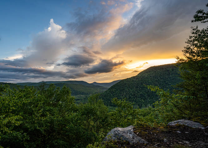
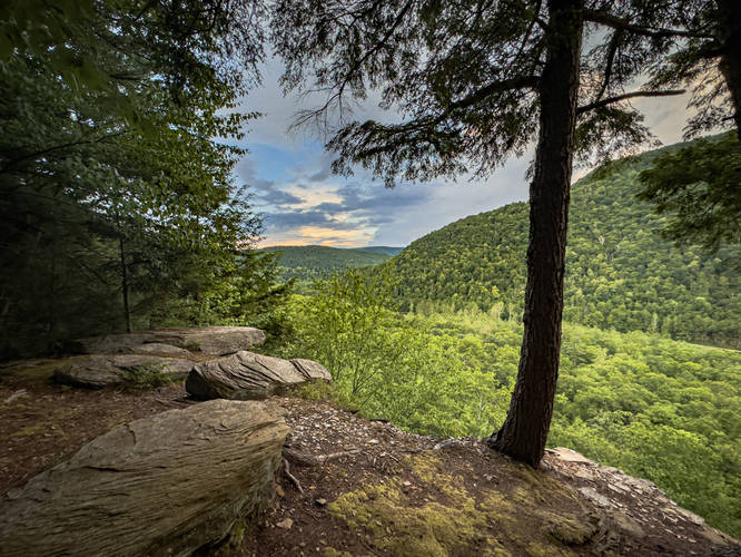
Rough Hill Trail is one of my favorite short hikes starting at the Sandy Bottom parking lot off route 87. The trail is a lollipop loop starting on the service road and cutting over and across 87 and then ascends up the mountain. There are two great lookouts on this trail, a lower and upper vista, the upper vista has great views looking down the valley towards Smiths Knob.

Parking
Hikers will find a small parking lot along the short road that leads into the Sandy Bottom Recreation Area. From the parking lot, hikers will find the trail.

Pets
Dogs are allowed if leashed and should be cleaned up after.

Camping & Backpacking
While there are no designated or pre-defined campsites along this trail, backcountry / primitive / dispersed camping is allowed within Loyalsock State Forest. Please follow all state forest rules and regulations if planning to camp.

Difficulty
This hike should be considered Moderate to Hard, hence the Hard difficulty for the average hiker. More experienced hikers may find this hike's difficulty to be Moderate at worst.

Warning
Timber Rattlesnake: This area is home to the Timer Rattlesnake which can often be found roaming the forest floors between late April and early October each year. Keep an eye out and if found, please give them plenty of space.
Explore 74 trails near Barbours, PA
  1. Parking

    41.397473, -76.759153
  2. Main Trailhead

    41.397467, -76.759458
  3. Rough Hill Vista

    41.399263, -76.75141
    Rough Hill Vista
  4. Lower Rough Hill Vista

    41.401011, -76.755111
    Lower Rough Hill Vista
Explore other routes for this Trail guide, added by the MyHikes' community via Trip Reports. To add your own hike as a Community Route for this Trail guide, leave a Trip Report with an attached GPX file.

Hazards

Ticks - Lyme Disease More Info (CDC)
Snakes
Poison Ivy/Oak

Seasons

All

Blaze Color

Yellow

Photo Albums

Trip Reports

Trail Guide By:
Shawng13 user profile picture
2.1 miles / 3.4 km
2.1 miles / 3.4 km
January 01, 2025
First hike of the new year and first time on this trail. Some downed trees on the way up other than that easy beautiful hike with a good view of the loyalsock state forest
Hiking
2.3 miles / 3.7 km
April 06, 2024
One of my favorite local hikes and knocked this one out again, this time with Janelle. The views are always good, but looking forward to seeing more green back on the trees and in the Loyalsock Valley.
Hiking
2.2 miles / 3.5 km
April 14, 2023
Short but challenging climb with lower & upper vistas that are both excellent! Trail well marked (yellow blaze). I went counter-clockwise up the loop section - the right/east side was definitely rockier & steeper, so nice to come back down the more gradual/less rocky other side of loop. Cool seeing Smith’s Knob in the distance since I hiked there earlier in the day!
Hiking

Weather Forecast

In Barbours, PA

Explore Hiking Trails

You May Also Like

Colorado's Million Dollar Highway - Plan a day's drive adventure along the iconic Million Dollar Highway in Colorado. Explore the best short trails, roadside stops, waterfalls, vistas, ghost towns, and hot springs within a ~6 hour road trip.
Explore

Colorado's Million Dollar Highway

Plan a day's drive adventure along the iconic Million Dollar Highway in Colorado. Explore the best short trails, roadside stops, waterfalls, vistas, ghost towns, and hot springs within a ~6 hour road trip.

Read
New York's Best Waterfalls - Whether you're planning a day hike, roadside stop, or a leisurely short walk, this guide provides hikers, travelers, and locals alike with 63 different locations to over 100 scenic waterfalls to help plan your next adventure!
Explore

New York's Best Waterfalls

Whether you're planning a day hike, roadside stop, or a leisurely short walk, this guide provides hikers, travelers, and locals alike with 63 different locations to over 100 scenic waterfalls to help plan your next adventure!

Read

Before you boogie...

Find our trail guides useful? Consider becoming a Supporter to unlock perks!

MyHikes is an indie platform that makes exploring public trails easier for everyone. The platform has no investors, no ads, and is owned and operated by one person, Dave Miller. Dave has personally mapped and written over 1,800 trail guides on MyHikes for the public to explore. MyHikes has helped millions outdoor enthusiasts plan their next adventure.

But it takes a lot of time 🕦, money 💰, work, and espresso shots ☕ to run MyHikes, including hiking , mapping , writing , and publishing new trails with high-quality (accurate) information... along with software engineering (coding) the platform like building new features, website and mobile app development (iOS and Android), site maintainance . and much much more.

Supporters unlock website and mobile app perks with an annual one-time payment of $25 (you renew) 😎👍. Or you can simply make a Donation of your choice. Otherwise, you can support us by telling your friends about MyHikes - both quick and free 🎉

Admin user profile picture

Dave Miller
MyHikes Founder