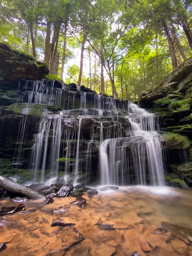
Rosecrans Falls in Loganton, Pennsylvania is an easy 1-mile out-and-back trail that leads to the beautiful waterfall known as Rosecrans Falls.
This is a short hike to a great waterfall. The Trailhead can be a little hard to find, but it sits along the right side of Nittany Ridge Rd in Loganton, PA. DO NOT hike down the gated road, as that is private property. Hikers will cross over the stream early in the hike, and then you'll want to remain on the left side (north side) of the stream to avoid the private property on the other side.
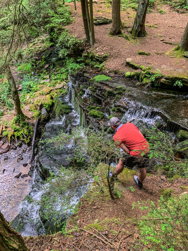
The hike will bring you to the top of the waterfall. There is a trail to the left that winds down and away from the falls and then switches back to bring you out at the bottom or base of the waterfall. The trail to the bottom is a little steep, narrow, and loose in spots - watch your step and hike at your own risk.
The first falls you come to is Rosecrans Falls. There is another waterfall back to the left, but it is on the private property, so please enjoy that one from a distance.
Parking
Hikers should fine parking near the trailhead, but do not block any private road gates.
Private Property Notice
Hikers should note that there's private property to the south side of the creek. Please respect the land owners and stay on public land.
Note
This waterfall is also named McElhattan Falls as this waterfall cascades down McElhattan Creek, as noted on OpenStreetMap.
This is a short hike to a great waterfall. The Trailhead can be a little hard to find, but it sits along the right side of Nittany Ridge Rd in Loganton, PA. DO NOT hike down the gated road, as that is private property. Hikers will cross over the stream early in the hike, and then you'll want to remain on the left side (north side) of the stream to avoid the private property on the other side.
The hike will bring you to the top of the waterfall. There is a trail to the left that winds down and away from the falls and then switches back to bring you out at the bottom or base of the waterfall. The trail to the bottom is a little steep, narrow, and loose in spots - watch your step and hike at your own risk.
The first falls you come to is Rosecrans Falls. There is another waterfall back to the left, but it is on the private property, so please enjoy that one from a distance.
Parking
Hikers should fine parking near the trailhead, but do not block any private road gates.
Private Property Notice
Hikers should note that there's private property to the south side of the creek. Please respect the land owners and stay on public land.
Note
This waterfall is also named McElhattan Falls as this waterfall cascades down McElhattan Creek, as noted on OpenStreetMap.