Loading...

WINTER SALE! 50% OFF Supporter Accounts — now through January 31st. Learn More.

Roberts Hill Loop Trail

The Roberts Hill Loop Trail at the Saw Mill Hills Conservation Area in Leeds, Massachusetts is a moderate 1.8 mile trail with a westward-facing view from the top of one of the hills.

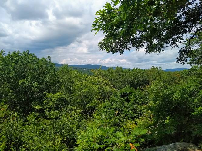
The Roberts Hill section of Saw Mill Hills has a large network of trails used by hikers and mountain bikers alike. This northern most parcel of Roberts Hill has a multi-colored trail network. A highlight here is a westward-facing view from the open hilltop where the blue- and red-blazed trails meet.

Route: Begin this 2-mile clockwise loop walk by going slightly uphill on the old woods road, which has historic significance—it was a stagecoach route to Albany in the early 1800s. Continue straight onto the orange-blazed trail, which soon overlaps with the blue-blazed trail. Following the orange blazes, the trail takes a sharp right turn leading away from neighboring private property. Bear left at the intersection with a rock outcropping on the right. After passing an old foundation on the right, the trail veers left and downhill, where it crosses the green-blazed trail. This gently inclining stretch of the orange-blazed trail is a former power line path where pole stumps can be seen in the shrubbery. For a long stretch, the trail passes through stands of young trees. Roberts Meadow Pond begins to come into view below (especially during the fall and winter months). A mossy rock to the right of a hemlock tree provides a look out point. Continue on this section of trail through new growth forest until you reach a rock-strewn intersection where the red-blazed trail comes in. Follow orange-red blazes for a short distance until the orange trail dips sharply to the left. Now, on the red-blazed trail, a gentle ascent begins. Pass a rock wall on the right as the trail hugs the hillside with the pond more visible below. Turning away from the pond, the trail slowly sweeps right and up to join the blue-blazed trail. Go right and follow the blue blazes noting the shrubby understory. The trail gets a bit steeper until you reach the top of Roberts Hill where a rocky lookout provides impressive views to the west. Return to the blue-blazed trail, which begins to descend. Look for numerous oak species, including chestnut, red, white, black, and scarlet. Pass through a peaceful hemlock grove, then turn left at the intersection with the green-blazed trail. Stay to the left, following the green blazes. The Mill River is ahead and below as you turn left and return to the orange blazed trail back to the trailhead.

Partner: This trail was submitted by our partner, Kestrel Land Trust. Kestrel Land Trust partners with the City of Northampton and friends groups to create, conserve, and care for public lands to help everyone connect with nature. The conservation lands here are owned by the City of Northampton and portions are monitored by Kestrel through a Conservation Restriction. The Leeds Civic Association and the Friends of Saw Mill Hills help maintain the trail.
Explore 212 trails near Leeds, MA

Know Before You Go

  • The Roberts Hill Loop Trail is a 1.8-mile moderate hike in Leeds, MA, featuring a network of multi-colored trails shared by hikers and mountain bikers.
  • The loop follows a historic stagecoach route and passes through diverse terrains, including young forests, a former power line path, and a hemlock grove, with views of Roberts Meadow Pond and the Mill River.
  • The trail's highlight is a westward-facing vista from the top of Roberts Hill, with the trail maintained through partnerships with the Kestrel Land Trust, the Leeds Civic Association, and the Friends of Saw Mill Hills.
Interactive topographic map for Roberts Hill Loop Trail located in Leeds, MA. Click the "View Map" button to load GPS coordinates and trail markers.
Get directions
Distance
1.8 mi
Difficulty
Moderate
Type
Loop
Est. Time
54 min
Elev. Gain
253'
Rating
0.0
Added
January 17, 2019
Updated
January 17, 2019

Weather Forecast

Loading...
Total Change
221'
Ascent
253'
Descent
249'
Loading...

Download the GPX Data for Offline Use

Supporters get exclusive access to download trail routes to the MyHikes app for offline use. Stay prepared on your adventure, even without an internet connection! Become a Supporter today to unlock this feature and hike with confidence.

Download Roberts Hill Loop Trail GPX Data to the MyHikes Mobile App

Features

Vista / Lookout Point
Dogs
Biking

Points of interest

  1. Parking

    42.348286, -72.702662
  2. Main Trailhead

    42.348082, -72.70288

Safety information

For your own safety: plan ahead, let someone know where you'll be, and hike at your own risk.

Availability

All seasons

Surface type

Dirt

Trip Reports (Reviews)

Your opinion matters! Be the first to rate this trail.

Ready to help fellow hikers? Add a trip report to share your experience and provide valuable insights for other hikers!

3.06 miles / 4.9 km
July 28, 2021

Explore other routes for this Trail guide, added by the MyHikes' community via Trip Reports (Reviews). To add your own hike as a Community Route for this Trail guide, leave a Trip Report and attached your GPX file!

Popular categories

Scenic mountain view representing vista trails
Vista trails
Scenic gorge of cascades representing waterfall trails
Waterfall hikes
Rugged mountain terrain representing summit trails
Summit trails
Scenic mountain view representing dog-friendly trails
Dog-friendly
Scenic campsite with a view representing camping trails
Camping trails
Appalachian Trail logo representing A.T. hikes
A.T. hikes

You May Also Like

Colorado's Million Dollar Highway - Plan a day's drive adventure along the iconic Million Dollar Highway in Colorado. Explore the best short trails, roadside stops, waterfalls, vistas, ghost towns, and hot springs within a ~6 hour road trip.
Explore

Colorado's Million Dollar Highway

Plan a day's drive adventure along the iconic Million Dollar Highway in Colorado. Explore the best short trails, roadside stops, waterfalls, vistas, ghost towns, and hot springs within a ~6 hour road trip.

Read
Glacier's Going-to-the-Sun Road - Discover the breathtaking beauty of Glacier National Park along the iconic Going-to-the-Sun Road. From stunning roadside stops to picturesque waterfalls and vistas, this engineering marvel offers endless opportunities for exploration.
Explore

Glacier's Going-to-the-Sun Road

Discover the breathtaking beauty of Glacier National Park along the iconic Going-to-the-Sun Road. From stunning roadside stops to picturesque waterfalls and vistas, this engineering marvel offers endless opportunities for exploration.

Read
🍪 We use cookies to learn about site usage and to serve map tiles. You may block cookies manually in the browser. By continuing you agree. Learn more