Loading...

🎉 Enjoy a Free 7-Day Supporter Trial and Unlock Exclusive Perks — No Credit Card Required. Learn more.

Roaring Run Hike

Directions
Map
Pictures
Send to App
Distance:
10.5 Miles / 16.9 km
Type:
Loop
Difficulty:
Hard
Time to Hike:
5 hours, ~15 minutes
Features:
Surface Type:
Dirt
Park:
George Washington National Forest
Town:
Shenandoah, Virginia
Directions:
38.557634, -78.635244
Added:
February 17, 2025
Updated:
April 05, 2025
Copy Trail Link Hiking this trail? Send a friend or family member a link to this trail guide for your own safety. Hike at your own risk (disclaimer)
Loading...
Loading...
1,731'

Total Change
2,410'

Ascent
2,410'

Descent

Download the Trail Route for Offline Use

Supporters get exclusive access to download trail routes to the MyHikes app for offline use. Stay prepared on your adventure, even without an internet connection! Become a Supporter today to unlock this feature and hike with confidence.

Send to App

Roaring Run Hike

This hike has old growth forest on Roaring Run, small waterfalls along Pitt Spring Run and a great view of the Luray Valley from the Pitt Spring Overlook. This is another one of those hikes that has a bit of everything. However, at 10.5 miles it can be a long one day loop.

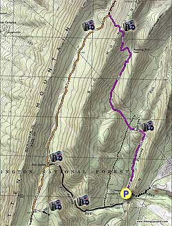
Start the hike by re-crossing Roaring Run over the concrete ford, turn left up the purple blazed Roaring Run Trail. In 0.1 miles cross the run continuing along the trail with Roaring Run now on your right. In 0.9 miles cross the run again and turn left as the trail now heads uphill. Shortly pass an old forestry road on your right, re-cross the run, and pass over a wide FS road 0.5 miles since making the left uphill.

Continue along the purple blazed trail and in another 0.5 miles cross a clear cut underground pipeline. The trail will become narrower as it ascends the valley. In 0.3 miles from the pipeline the trail is diverted slightly to to the right. If you miss the detour and continue straight the trail will become blocked with blow downs and will appear to end. Just continue for another 50 yards and you will see the trail uphill 20 yards on your right. Continue on the purple blazed trail as it makes a switchback to the right, then back left before turning uphill in another 0.3 miles.

Climb Big Mountain on the purple blazed trail and reach the ridge and small camp site in another 0.5 miles. Descend Big Mountain on it's west side for 0.5 miles where the purple blazed trail ends and arrives at the Big Mountain forestry service (FS) road, which is also the orange blazed Mountain South Trail.

Turn left downhill on the orange blazed FS road for 2.8 miles. You may see one or two vehicles, so remember to keep an ear out. Pitt Spring and the continuation of the orange blazed Mountain South Trail turns right where the FS road you have been following makes a sharp left. There is a closed gate and small wooden footbridge that crosses Pitt Spring Run.

Turn right over the footbridge, pass the spring, and climb the orange blazed Mountain South Trail for 1.0 mile to the intersection of the white blazed Pitt Spring Overlook Trail. Turn left on the white blazed trail and in 0.2 miles pass a side trail that goes to the right. In another 0.1 miles arrive at the Pitt Spring Overlook and foundation of an old lookout tower. Return back down the white blaze trail, turn right on the orange blazed trail retracing your route back to Pitt Spring, and re-crossing the footbridge over Pitt Spring Run.

Turn right downhill on the FS road you had been following earlier. The FS road is narrow at this point so remember to keep an ear out for traffic. Pass an old FS road that heads uphill on the left in 1.4 miles, and in another 0.5 miles TURN LEFT where the road forks (remaining straight crosses a concrete ford over Pitt Spring Run). In 0.2 miles arrive back at Catherine Furnace and the parking area.

Explore 98 trails near Shenandoah, VA
  1. Parking

    38.557634, -78.635244
  2. Main Trailhead

    38.557624, -78.635073
No community routes found. To add your own hike as a Community Route for this Trail guide, leave a Trip Report with an attached GPX file.

Hazards

Ticks - Lyme Disease More Info (CDC)
Snakes
Poison Ivy/Oak

Seasons

All

Photo Albums

Trip Reports

Trail Guide By:
HikingUpward user profile picture
10.5 miles / 16.9 km

Weather Forecast

In Shenandoah, VA

Explore Hiking Trails

You May Also Like

New York's Best Waterfalls - Whether you're planning a day hike, roadside stop, or a leisurely short walk, this guide provides hikers, travelers, and locals alike with 63 different locations to over 100 scenic waterfalls to help plan your next adventure!
Explore

New York's Best Waterfalls

Whether you're planning a day hike, roadside stop, or a leisurely short walk, this guide provides hikers, travelers, and locals alike with 63 different locations to over 100 scenic waterfalls to help plan your next adventure!

Read
25 Best Day Hikes in North Carolina - Discover the top 25 best day hikes in North Carolina, from breathtaking waterfalls to mountain peaks. Explore hidden gems, scenic views, and trails suitable for all skill levels, perfect for your next outdoor adventure.
Explore

25 Best Day Hikes in North Carolina

Discover the top 25 best day hikes in North Carolina, from breathtaking waterfalls to mountain peaks. Explore hidden gems, scenic views, and trails suitable for all skill levels, perfect for your next outdoor adventure.

Read

Before you boogie...

Find our trail guides useful? Consider becoming a Supporter to unlock perks!

MyHikes is an indie platform that makes exploring public trails easier for everyone. The platform has no investors, no ads, and is owned and operated by one person, Dave Miller. Dave has personally mapped and written over 1,800 trail guides on MyHikes for the public to explore. MyHikes has helped millions outdoor enthusiasts plan their next adventure.

But it takes a lot of time 🕦, money 💰, work, and espresso shots ☕ to run MyHikes, including hiking , mapping , writing , and publishing new trails with high-quality (accurate) information... along with software engineering (coding) the platform like building new features, website and mobile app development (iOS and Android), site maintainance . and much much more.

Supporters unlock website and mobile app perks with an annual one-time payment of $25 (you renew) 😎👍. Or you can simply make a Donation of your choice. Otherwise, you can support us by telling your friends about MyHikes - both quick and free 🎉

Admin user profile picture

Dave Miller
MyHikes Founder