Discover the awe-inspiring beauty of Roaring Brook Falls, one of the most accessible and impressive waterfalls in the Adirondacks of New York. Nestled in the scenic Keene Valley of the Adirondacks, the Roaring Brook Falls Trail provides a 0.7 mile out-and-back hike with breathtaking views of the 300-foot waterfall.
Hike
This short hike starts at the Giant Mountain parking area, where a well-marked trail leads you through picturesque woodlands. After a quick 0.1-mile stroll, the trail splits and hikers will keep right at the junction to head to the base of Roaring Brook Falls. Along the way, enjoy the tranquility of the forested surroundings like rock cliffs, large boulders, and evergreen forests, with only minor rises and dips in terrain as it undulates its way uphill to the 300-foot tall waterfall.
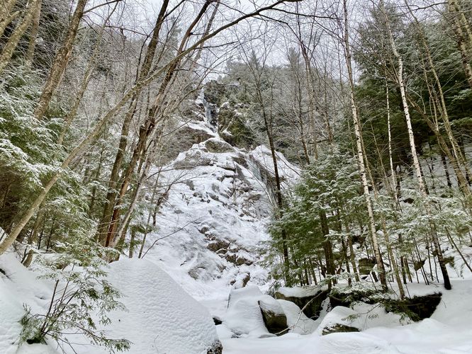
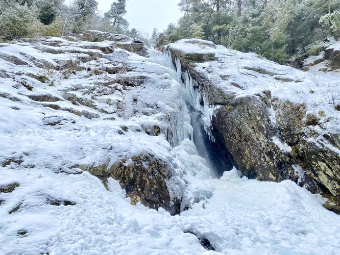
Upon reaching the base of the falls, marvel at the sheer grandeur of the towering rock wall as it stretches 300 feet into the sky. While the brook may not always live up to its roaring name, the captivating beauty of the cascading waters is a sight to behold.
Whether exploring the trail or enjoying the view from the road, Roaring Brook Falls promises an unforgettable experience for all who visit. With its easy accessibility and breathtaking beauty, it's no wonder this iconic waterfall captivates visitors year-round. During our winter hike here, we were able to reach the base of the waterfall as the creek was frozen over with an ice sheet over 1-foot thick. Don't miss the opportunity to witness the natural wonder of Roaring Brook Falls during your Adirondack adventure.
Parking
Hikers will find a large parking lot at the coordinates provided, at the base of Giant Mountain located along NY-73. The lot is large enough to fit over a dozen vehicles.
Pets
Dogs are allowed only if leashed and must be cleaned up after.
Hike
This short hike starts at the Giant Mountain parking area, where a well-marked trail leads you through picturesque woodlands. After a quick 0.1-mile stroll, the trail splits and hikers will keep right at the junction to head to the base of Roaring Brook Falls. Along the way, enjoy the tranquility of the forested surroundings like rock cliffs, large boulders, and evergreen forests, with only minor rises and dips in terrain as it undulates its way uphill to the 300-foot tall waterfall.
Upon reaching the base of the falls, marvel at the sheer grandeur of the towering rock wall as it stretches 300 feet into the sky. While the brook may not always live up to its roaring name, the captivating beauty of the cascading waters is a sight to behold.
Whether exploring the trail or enjoying the view from the road, Roaring Brook Falls promises an unforgettable experience for all who visit. With its easy accessibility and breathtaking beauty, it's no wonder this iconic waterfall captivates visitors year-round. During our winter hike here, we were able to reach the base of the waterfall as the creek was frozen over with an ice sheet over 1-foot thick. Don't miss the opportunity to witness the natural wonder of Roaring Brook Falls during your Adirondack adventure.
Parking
Hikers will find a large parking lot at the coordinates provided, at the base of Giant Mountain located along NY-73. The lot is large enough to fit over a dozen vehicles.
Pets
Dogs are allowed only if leashed and must be cleaned up after.