Roan Mountain and the Roan Highlands are famous for having the largest natural Catawba rhododendron gardens in the world. The heath shrubs, concentrated among Roan Mountain Gardens, Carvers Gap, Jane Bald, and Grassy Ridge Bald, produce beautiful pink and purple flowers once a year during the month of June. Due to the popularity of the rhododendron blooms and the vistas from the mountaintops, Carvers Gap can be overrun most summer weekends. Carvers Gap is the unofficial bisection of the Roan Highlands and the shortest access to the eastern section of expansive balds. By comparison, Roan Mountain on the west side of Carvers Gap is a mixture of heath balds, spruce-fir forests, and rugged cliffs. This companion hike to the popular Roan Highlands hike explores everything Roan Mountain has to offer. Beginning at Hughes Gap, the hike follows the Appalachian Trail north (compass south) through hardwood forests before climbing to the heights of Roan Mountain. From there you’ll take the Cloudland Trail to views from Roan High Bluff and explore the Roan Mountain Gardens. If you decide to continue the Appalachian Trail, you will be able to summit the high point of the Unaka Mountains and experience outstanding views from the balds. You have the option of doing all of this as a long day hike, or a starting point for a long backpacking trip.
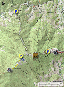
- Mile 0.0 – Parking is available on the shoulders of Hughes Gap Rd/TN 2680. From Hughes Gap, follow the Appalachian Trail (white blaze) south (trail direction north) through sparse hardwood forests with a lush understory.
- Mile 0.4 – Y-junction with a side trail on the right to a spring.
- Mile 2.5 – Cross the wooded summit of Beartown Mountain (5,480 feet).
- Mile 2.8 – Pass through Ash Gap. The wide gap is covered with grasses and ferns on both sides of the trail. There are multiple large campsites.
- Mile 2.85 – The last campsite on the right side of the trail has a spur trail leading to a spring. Beyond Ash Gap the AT begins a 900-foot climb to Roan Mountain on many tight switchbacks. As you ascend the forests change from hardwoods to a mixture of pine, spruce, and fir.
- Mile 4.0 – T-junction in a small clearing with the Cloudland Trail on the right. The Appalachian Trail turns left back into the forest. Turn right on the Cloudland Trail [1000] (yellow blaze). Since this is a T-hike, you can choose either direction. The Cloudland Trail immediately passes through a large, flat field. This is the summit of Cloudland Mountain (6,200 feet) and the former site of the Cloudland Hotel, originally built in 1884.
- Mile 4.1 – The trail drops down into the Cloudland parking lot. Walk through the parking lot and continue the trail on the west side of the lot.
- Mile 4.3 – Side trail on the right to a nice cliff overlook. The cliff provides northwest views of the Tennessee flatlands and west views of Unaka Mountain.
- Mile 4.5 – On the left side of the trail is NC 1348 and the Roan Mountain Gardens parking lot. As you continue west on the flat Cloudland Trail, you’ll pass through varied forests of the Roan Mountain massif, which is dominated by spruce-fir forests and heath bald forests (mountain laurel, blueberry, and rhododendron).
- Mile 4.6 – Y-junction with a trail on the left to bus parking.
- Mile 4.8 – Cloudland Trail crosses NC 1348.
- Mile 5.0 – Cloudland Trail crosses NC 1348 a second time at the Roan Mountain Gardens Picnic Area.
- Mile 5.4 – The Cloudland Trail ends at the Roan High Bluff observation deck. Roan High Bluff (6,267 feet) is a western peak of Roan Mountain featuring tall cliffs with expansive views from west to north. Unaka Mountain is the large, broad peak due west. The true summit of Roan High Bluff is located off to the right of the deck and is off-limits to protect habitats of threatened and endangered bird species. If you are doing the South Beyond 6000 Challenge, then reaching the observation deck is enough to claim the peak.
- Mile 6.3 – Turn right towards the Roan Mountain Gardens parking lot. The Roan Mountain Garden Trail [1002] (no blaze) begins beside the bathrooms. This National Recreation Trail is divided into three loops, the Upper Loop is paved and wheelchair accessible while the Middle and Lower Loops are standard hiking paths. These three loops pass through dense natural Catawba rhododendron gardens. These are typically the latest rhododendrons to bloom in the Roan Highlands.
- Mile 6.5 – Turn right at the Upper Loop Y-split.
- Mile 6.6 – Turn right at the Upper and Middle Loop [1002A] Y-junction. A left turn is the shortest option closing the Upper Loop.
- Mile 6.7 – At a cross junction continue straight on the Lower Loop [1002B]. On the Lower Loop you’ll get views south.
- Mile 6.9 – Returning to the cross junction continue straight on the eastern side of the Middle Loop.
- Mile 7.0 – At a T-junction continue right on the Upper Loop.
- Mile 7.1 – Roan Mountain Garden Trail ends at the parking lot. Reconnect with the Cloudland Trail and turn right.
- Mile 7.55 – Cloudland Trail ends at the Appalachian Trail. Turn right passing by an old chimney in Toll House Gap. The AT climbs towards the summit of Roan High Knob on a wide, rocky grade that was the former carriage path to reach the Cloudland Hotel.
- Mile 8.1 – T-junction with a blue-blazed side trail to the Roan High Knob Shelter.
- Mile 8.2 – Trail ends at the Roan High Knob Shelter. Originally built in 1933 to house fire watchmen for the neighboring tower, it is the highest elevation shelter for the entire Appalachian Trail. Remnants of the fire tower are near the shelter. The wide, flat summit has little undergrowth among the tall spruce and fir trees and is excellent for tent camping.
- Mile 8.25 – Summit of Roan High Knob (6,285 feet), the tallest peak in the Unaka Mountains.
- Mile 8.4 – Turn right on the Appalachian Trail. The AT descends over 600 feet for the next 1.5 miles on seven long switchbacks passing through entrancing spruce and fir forests. The composition of conifers changes as you get closer to Carvers Gap.
- Mile 9.9 – Cross NC 261/TN 143 at Carvers Gap (5,512 feet). On the east side of Carvers Gap the AT ascends through impressive stands of Catawba rhododendrons. You may even spot one of the lone flame azalea bushes on the mountainside, which has bright orange blooms.
- Mile 10.5 – Reach the broad, grassy summit of Round Bald (5,826 feet). Round Bald has outstanding 360° views of many of the highest peaks in North Carolina and Tennessee. Roan Mountain, covered by blackish spruce-fir forests, rises to the west above Carvers Gap. The tall peaks of the Black Mountains are located in the distant southwest. You should be able to see the distinctive summits Hawksbill Mountain and Table Rock Mountain of Linville Gorge to the south-southeast. The Appalachian Trail drops down to Engine Gap and climbs up to Jane Bald and Grassy Ridge Bald due east. There are large stands of Catawba rhododendron on Jane Bald and Grassy Ridge Bald. The distant balds of Hump and Little Hump Mountain are located east-northeast to the left of Grassy Ridge Bald. Hump Mountain is the larger peak on the left of these twin summits. If you wish to hike to these balds, check out our Roan Highlands hike.
- Mile 13.6 – Keep right on the Appalachian Trail at the junction with the Cloudland Trail.
- Mile 16.3 – Hike ends at Hughes Gap.