The Rimrock Loop Trail at Allegheny National Forest in Bradford, Pennsylvania is a moderate 10.5 mile hike and is by far one of the best backpacking trails in the national forest.
The hike starts off at the parking lot off of Route 59 and heads along a short spur trail for about 0.7 miles. After the 0.7 mile hike in, you'll reach the Rimrock Loop - take a right-hand turn at the sign to ensure an easier hike back since the elevation gain heading left on the main loop is worse than heading right. You won't hit steep elevation gain (or loss) until the northwest portion of the loop. Follow the blue blazes and white/silver reflectors.
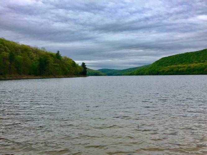
After 5.5 miles into the hike, you'll reach the campground which sits right on the Allegheny Reservoir - $12/night fee. If you just want to get down to the campground and don't want to do the whole loop, you can head left at the loop trail sign (0.7 miles in from parking) and head ~4.5 miles to the campgrounds for a ~9 mile trip out-and-back.
We noticed the best scenery is on the southern half of the loop along the reservoir, but on the northern portion of the loop, there are campsites along a creek that runs adjacent to the trail. The campsites along the northern creek are quiet and secluded whereas the campsites along the reservoir are closer together and you can usually hear your neighbors during busy seasons. You can use either the reservoir or the creek along the northern portion of the loop to filter water. There's an additional creek along the southern portion of the loop as well.
Camping
Backpackers will find free dispersed/primitive/backcountry camping off-trail, but must follow the National Forest rules and regulations.
Additionally, at the designated reservoir backcountry campground there are first-come first-serve backcountry campsites along the lake. There's often a working potable water well you can use to refill your bottles, located on the main trail. There's a $12/night fee, which you can pay for at the trailhead with cash and paper slips. The campground can be a bit difficult to find since there are only a couple of signs for it. The main campground spur trail leads into other small trails that eventually lead to campsites along the lake. Most of the campsites are separated by large bushes, shrubs, and grass, which makes it a nice private area to camp despite potentially having camping neighbors close-by.
Waterfalls
I added waterfalls here because there are numerous small waterfalls along the creeks throughout the entire trail. There are slightly larger waterfalls along the creek in the northern portion of the loop.
Popularity
Unfortunately the Rimrock Loop Trail is one of the more popular backpacking trails at Allegheny National Forest, so you're likely to see other groups out on the trail and especially at the reservoir campsites. Backpacking during off-season is a better time to find seclusion along the Rimrock Loop.
Pets
Dogs are allowed if leashed.
The hike starts off at the parking lot off of Route 59 and heads along a short spur trail for about 0.7 miles. After the 0.7 mile hike in, you'll reach the Rimrock Loop - take a right-hand turn at the sign to ensure an easier hike back since the elevation gain heading left on the main loop is worse than heading right. You won't hit steep elevation gain (or loss) until the northwest portion of the loop. Follow the blue blazes and white/silver reflectors.
After 5.5 miles into the hike, you'll reach the campground which sits right on the Allegheny Reservoir - $12/night fee. If you just want to get down to the campground and don't want to do the whole loop, you can head left at the loop trail sign (0.7 miles in from parking) and head ~4.5 miles to the campgrounds for a ~9 mile trip out-and-back.
We noticed the best scenery is on the southern half of the loop along the reservoir, but on the northern portion of the loop, there are campsites along a creek that runs adjacent to the trail. The campsites along the northern creek are quiet and secluded whereas the campsites along the reservoir are closer together and you can usually hear your neighbors during busy seasons. You can use either the reservoir or the creek along the northern portion of the loop to filter water. There's an additional creek along the southern portion of the loop as well.
Camping
Backpackers will find free dispersed/primitive/backcountry camping off-trail, but must follow the National Forest rules and regulations.
Additionally, at the designated reservoir backcountry campground there are first-come first-serve backcountry campsites along the lake. There's often a working potable water well you can use to refill your bottles, located on the main trail. There's a $12/night fee, which you can pay for at the trailhead with cash and paper slips. The campground can be a bit difficult to find since there are only a couple of signs for it. The main campground spur trail leads into other small trails that eventually lead to campsites along the lake. Most of the campsites are separated by large bushes, shrubs, and grass, which makes it a nice private area to camp despite potentially having camping neighbors close-by.
Waterfalls
I added waterfalls here because there are numerous small waterfalls along the creeks throughout the entire trail. There are slightly larger waterfalls along the creek in the northern portion of the loop.
Popularity
Unfortunately the Rimrock Loop Trail is one of the more popular backpacking trails at Allegheny National Forest, so you're likely to see other groups out on the trail and especially at the reservoir campsites. Backpacking during off-season is a better time to find seclusion along the Rimrock Loop.
Pets
Dogs are allowed if leashed.