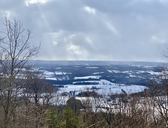
The Ridge Trail at the Mount Pisgah County Park in Troy, Pennsylvania is an easy 1-mile out-and-back trail that features a beautiful view southwest facing the Armenia Mountain and the Armenia Mountain Wind Farm.
This short but peaceful trail runs a ridge of Mount Pisgah that runs east. The trail begins by passing a metal gate used to prevent motorized vehicles from entering. During the winter, snowmobiles find their way around the gate; however, it's unclear if they're actually allowed. The trail is blazed with yellow blazes, but hikers will find several blue circles tagged on trees - potentially indicating a cross-country ski trail.
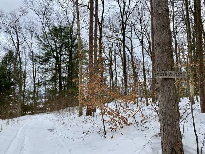
The trail will pass the Foxtrot Trail around mile 0.1 before the trail heads uphill among the conifers before reaching the main vista along the trail.
Ridge Overlook
The Mount Pisgah Ridge Overlook is located at mile 0.3. There's a picnic table available so hikers can sit and relax next to a beautiful view.
Heading eastward from the overlook is easy hiking. The trail will head downhill slightly before leveling out for a short while - approximately 0.2-miles or so. At mile 0.5 the trail heads down a steeper grade where it eventually reaches Mount Pisgah State Park.
Here, we ended the track and went back to parking for a 1-mile out-and-back hike; however, the trail continues onward for a little bit further.
Trail Length
Technically the trail runs all the way to reach the Mount Pisgah State Park; however, we cut our hike short just before the trail started heading downhill at a steeper and steady pace - approximately 0.2-miles from where the county park meets the state park. This track will bring the hiker 0.5-miles in one-way before heading back to parking.
Parking Hikers will find a very small parking turnout next to the trailhead, at the coordinates provided. There's a beautiful vista at the parking area that faces northeast. The lot is large enough to fit about 5 vehicles.
Pets
Dogs are allowed if leashed.
Trail Junctions
This trail connects to the Foxtrot Trail (not yet mapped on MyHikes as of December 2020) located just 0.1-miles from the trailhead.
Blaze Color
This trail follows yellow blazes.
Mountain Biking
This trail permits mountain biking.
This short but peaceful trail runs a ridge of Mount Pisgah that runs east. The trail begins by passing a metal gate used to prevent motorized vehicles from entering. During the winter, snowmobiles find their way around the gate; however, it's unclear if they're actually allowed. The trail is blazed with yellow blazes, but hikers will find several blue circles tagged on trees - potentially indicating a cross-country ski trail.
The trail will pass the Foxtrot Trail around mile 0.1 before the trail heads uphill among the conifers before reaching the main vista along the trail.
Ridge Overlook
The Mount Pisgah Ridge Overlook is located at mile 0.3. There's a picnic table available so hikers can sit and relax next to a beautiful view.
Heading eastward from the overlook is easy hiking. The trail will head downhill slightly before leveling out for a short while - approximately 0.2-miles or so. At mile 0.5 the trail heads down a steeper grade where it eventually reaches Mount Pisgah State Park.
Here, we ended the track and went back to parking for a 1-mile out-and-back hike; however, the trail continues onward for a little bit further.
Trail Length
Technically the trail runs all the way to reach the Mount Pisgah State Park; however, we cut our hike short just before the trail started heading downhill at a steeper and steady pace - approximately 0.2-miles from where the county park meets the state park. This track will bring the hiker 0.5-miles in one-way before heading back to parking.
Parking Hikers will find a very small parking turnout next to the trailhead, at the coordinates provided. There's a beautiful vista at the parking area that faces northeast. The lot is large enough to fit about 5 vehicles.
Pets
Dogs are allowed if leashed.
Trail Junctions
This trail connects to the Foxtrot Trail (not yet mapped on MyHikes as of December 2020) located just 0.1-miles from the trailhead.
Blaze Color
This trail follows yellow blazes.
Mountain Biking
This trail permits mountain biking.