This hike in Southwest Virginia takes advantage of a big curve in
the Appalachian Trail to form a loop hike in a relatively uncrowded
portion of the A.T. Much of the Ribble Trail is actually an earlier
A.T. alignment, so hikers can experience both the present and former
Appalachian Trail.
You can hike this loop in either direction. This description is for a clockwise hike, which allows you to get the major climb completed early in the hike. Note also that there are a couple of wonderful hiker hostels near this loop if you wish to stay longer. Just north is the legendary Woods Hole Hostel with its famous communal meals, and to the south is the relatively new Weary Feet Hostel (website). HikingUpward staff have used both hostels while hiking in this area, and highly recommend both!
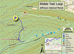
- Mile 0.0 – The trailhead is located at a large, unmarked parking area on the right side of Dismal Creek Road just after the road takes a turn to the left. It is marked on Google Maps as “Ribble Trailhead.” On the way to the trailhead, the road passes both the Falls of the Dismal Creek and the Forest Service’s Walnut Flats Campground (open mid-May to mid-December). This loop’s trailhead itself is located just before a gate on the road, and this gate is closed parts of the year. If you pass a road gate, you have gone too far. In the parking area, there are two separate entrances into the woods. Take the old road with a gate. This is the Ribble Trail’s uphill route and is blazed blue.
- Mile 0.9 – Pass a dirt woods road. This is a continuation of the road that was gated back at the trailhead. Cross and continue.
- Mile 1.2 – Cross another dirt woods road, again part of the same road you came in on. The trail dips just after this then climbs somewhat steeply.
- Mile 2.1 – Pass by a small pond and the remains of an old cabin, marked on the USGS map as the “Honey Spring Patrol Cabin.” (Patrol Cabins housed backcountry rangers.) The trail literally passes right next to and around the location of the privy for this cabin, and there is still a shallow hole there.
- Mile 2.2 – The Appalachian Trail crosses here. To your left, the A.T. goes about 500 feet to a road (FS 612) and parking area. Straight ahead, the Ribble Trail ends about 100 feet away at a gated woods road (FS 103) that also has a parking opportunity just outside the gate. So, if you reach a road, you have gone too far! Where the Ribble Trail ends at FS 103, just past the A.T., you may find an ancient trail sign on its last legs. Take a right at the intersection with the A.T. and follow the white blazes southbound on the AT.
- Mile 2.9 – The hike reaches its highest point where the A.T. takes a right at a woods road. You can take a left here as well and hike the road to a radio tower where there are reportedly some good views to the north. We did not take this side route, as we knew we could find similar views later in this loop. However, other hikers have recommended the side trip and report that there is also a nice campsite - assuming you are ok with spending the night next to a large electronic communications tower.
- Mile 5.2 – The A.T. remains fairly level for a couple of miles without views, and part of the time follows an old road just below the ridge of Sugar Run Mountain. At 5.2 and 5.3 miles into the loop are multiple overlooks just off the main trail – these provide the best vistas of the hike. After these vistas there are multiple campsites scattered along the ridge next to the A.T.
- Mile 6.2 – The A.T. turns right and begins a steep downhill.
- Mile 7.0 – Cross Dismal Creek for the first of many times. The trail starts to become much wetter as it parallels the track of Dismal Creek. Thick stands of rhododendron create the A.T.’s famous “green tunnel” effect.
- Mile 7.6 – A side trail leads a short distance to the Wapiti Shelter, which also contains some campsites. The hike is level after this point for the rest of the loop.
- Mile 7.7 – Not long after passing the shelter, watch for the trail to take a sharp right turn where it intersects with the end of the Lion’s Den Road (closed to traffic). It is very easy to miss this turn and start walking down the road. Look to the right, and you will see a small bridge over a stream tributary through the rhododendrons. Follow this to stay on the A.T.
- Mile 7.9 – After crossing the main branch of Dismal Creek on another bridge, reach a large pond. There is a campsite here to the left. Use care in following the trail here, as the A.T. follows the edge of the pond, then cuts left away from the pond’s shoreline.
- Mile 8.3 – Trail crosses a feeder stream over a wooden bridge.
- Mile 8.7 – Another stream crossing, another bridge.
- Mile 9.7 – Leave the AT, turning onto the Ribble Trail at its southernmost point. There was no trail sign indicating the Ribble Trail when we hiked here, only a new A.T. sign and some blue blazes on the Ribble’s route.
- Mile 10.0 - Shortly after fording a stream crossing, the Ribble Trail emerges from a thick stand of rhododendrons to the trailhead parking lot where you left your vehicle.