The Red Run Falls via Klondike Trail hike at Tioga State Forest near Arnot, Pennsylvania is an easy 3.2-mile out-and-back trail that features the 12-foot tall Red Run Falls, two human-made ponds to reduce stream acidity in Lick Creek, and also has a beautiful open vista at the end of the trail.
Trails
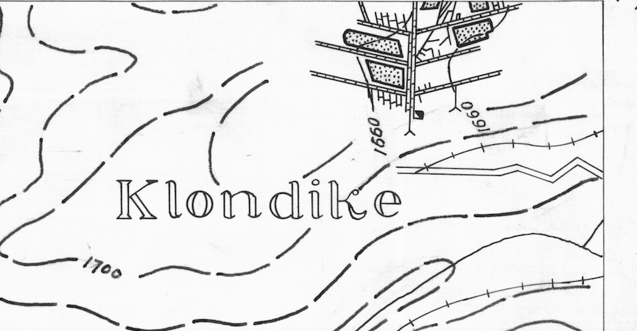
This hike follows one named trail - Klondike Road / Klondike Trail. Please note that the actual foot path did not have any blaze colors as of March, 2022 and it technically leads downhill (near the waterfall) and back to the road; however, the interesting points-of-interest lie down the service road.
Hike Description
This hike begins at the yellow trailhead service road gate along Klondike Road and follows the service road / trail along a flat elevation grade. The trail does not have much to note aside from some 4-foot tall rock ledges that follow alongside in the woods to the north.
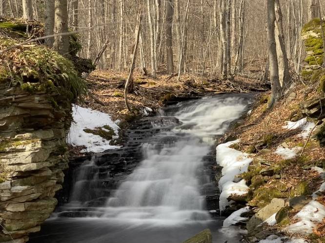
Red Run Falls - Mile 1
Around mile 0.9, hikers will reach a turn in the road - where the named trail heads downhill and connects to Landrus Road; however, keep going to reach a human-built bridge that spans Red Run Creek at mile 1. Here, look north and hikers will find the 12-foot tall Red Run Falls cascading into the small rocky canyon below. This waterfall is a welcomed sight along what we assumed was going to be a fairly-boring trail. The waterfall can be explored a bit further by hiking up next to it. I attempted to skirt below the rock ledges to reach the base of the waterfall, but noticed most of the rock ledges are leaning inward toward the creek - to keep things safe I skipped that and went above the waterfall instead.
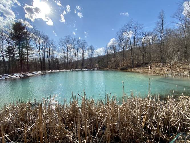
Acidity-Reducing Ponds - Klondike Treatment System
After passing Red Run Falls, hikers will continue heading west to reach the human-made acidity-reducing ponds for Lick Creek. These ponds exist to help Lick Creek, and thus Babb Creek downstream, reduce their acidity levels which are unnaturally raised by acid run-off from long-closed nearby mines. These ponds were built in 1998 under a project named the Klondike Treatment System, which treats the water run-off from the old Klondike Mine. Here's more information about the Restoration of the Babb Creek Watershed. The first pond intakes water that runs directly out from the Klondike mine's drift opening and through the PVC piping that stems out from under the road and hovers over the pond. The pond at the bottom of the hill has a beautiful turquoise color that stands out the most, making this an unnatural and hidden gem in Tioga State Forest. While the water color is unnatural here, it actually helps the stream retain a balance in acidity to allow fish and other creatures to actually live in the waters downstream. Without these ponds, the creeks would be uninhabitable. Note that all of this water is actually running out of and directly from the old Klondike Mine.
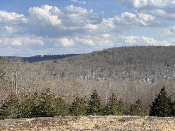
Mountain Vista
At the end of the service road lies the open area where hikers will find a nice vista of the neighboring mountains. This is likely a popular hunting area; however, this vista area would provide a beautiful secluded backpacking and camping opportunity outside of hunting season.
Parking
Hikers will find parking by the coordinates provided just off of Landrus Road on Klondike Road. The parking lot sits next to the service road gate and is large enough for three vehicles. Note that the parking lot exists just beyond the electric lines.
Pets
Dogs are allowed if leashed and their waste should be carried out by the hiker.
Camping and Backpacking
While there were no campsites located off-trail here, backpackers and campers can setup a campsite if they wish via dispersed / primitive / backcountry camping. Please follow all state forest rules and regulations when camping.
Trails
This hike follows one named trail - Klondike Road / Klondike Trail. Please note that the actual foot path did not have any blaze colors as of March, 2022 and it technically leads downhill (near the waterfall) and back to the road; however, the interesting points-of-interest lie down the service road.
Hike Description
This hike begins at the yellow trailhead service road gate along Klondike Road and follows the service road / trail along a flat elevation grade. The trail does not have much to note aside from some 4-foot tall rock ledges that follow alongside in the woods to the north.
Red Run Falls - Mile 1
Around mile 0.9, hikers will reach a turn in the road - where the named trail heads downhill and connects to Landrus Road; however, keep going to reach a human-built bridge that spans Red Run Creek at mile 1. Here, look north and hikers will find the 12-foot tall Red Run Falls cascading into the small rocky canyon below. This waterfall is a welcomed sight along what we assumed was going to be a fairly-boring trail. The waterfall can be explored a bit further by hiking up next to it. I attempted to skirt below the rock ledges to reach the base of the waterfall, but noticed most of the rock ledges are leaning inward toward the creek - to keep things safe I skipped that and went above the waterfall instead.
Acidity-Reducing Ponds - Klondike Treatment System
After passing Red Run Falls, hikers will continue heading west to reach the human-made acidity-reducing ponds for Lick Creek. These ponds exist to help Lick Creek, and thus Babb Creek downstream, reduce their acidity levels which are unnaturally raised by acid run-off from long-closed nearby mines. These ponds were built in 1998 under a project named the Klondike Treatment System, which treats the water run-off from the old Klondike Mine. Here's more information about the Restoration of the Babb Creek Watershed. The first pond intakes water that runs directly out from the Klondike mine's drift opening and through the PVC piping that stems out from under the road and hovers over the pond. The pond at the bottom of the hill has a beautiful turquoise color that stands out the most, making this an unnatural and hidden gem in Tioga State Forest. While the water color is unnatural here, it actually helps the stream retain a balance in acidity to allow fish and other creatures to actually live in the waters downstream. Without these ponds, the creeks would be uninhabitable. Note that all of this water is actually running out of and directly from the old Klondike Mine.
Mountain Vista
At the end of the service road lies the open area where hikers will find a nice vista of the neighboring mountains. This is likely a popular hunting area; however, this vista area would provide a beautiful secluded backpacking and camping opportunity outside of hunting season.
Parking
Hikers will find parking by the coordinates provided just off of Landrus Road on Klondike Road. The parking lot sits next to the service road gate and is large enough for three vehicles. Note that the parking lot exists just beyond the electric lines.
Pets
Dogs are allowed if leashed and their waste should be carried out by the hiker.
Camping and Backpacking
While there were no campsites located off-trail here, backpackers and campers can setup a campsite if they wish via dispersed / primitive / backcountry camping. Please follow all state forest rules and regulations when camping.


