Loading...

WINTER SALE! 50% OFF Supporter Accounts — now through January 31st. Learn More.

Red Loop

The Red Loop at the East Glenwood Open Space Preserve in Scotts Valley, California is a moderate 1-mile loop trail that features wide open views of the hills of the area and includes an abundance of wildlife during the Spring like rabbits, bullfrogs, and other open space critters.

Hike Description
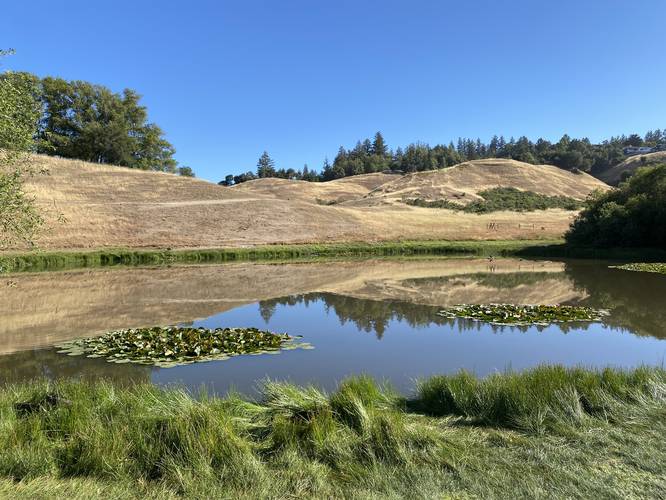
This trail begins after hikers make their way down the 0.4-mile Entrance Trail. In this GPS recording, the track heads in a clockwise direction, first passing views of Scotts Valley before hitting the banks of a small pond. When entering cow fence areas, be sure to close the gate behind you - like at the pond.

After passing the pond, the trail will head up into the hills, meandering around with some views and wildflowers, like wild lupine, along the way. Eventually the trail makes its way back to the start, but not before passing through a shaded forest, which is a nice break from the mostly sun-exposed trail.

Pets
Note that dogs are not allowed due to the East Glenwood Open Space Preserve's use of cow grazing to keep rare wildlife (both plants and animals) flourishing here. For nearby dog-friendly trails, check out the West Glenwood Preserve instead.

Warnings
Rattlesnakes, mountain lion, wasps, poison oak, ticks, and sun exposure.

Prohibited
No camping, no plant/animal/mineral collecting, no motorized vehicles or horses. No smoking, no alcohol.
Explore 20 trails near Scotts Valley, CA

Know Before You Go

  • The Red Loop is a 1.2-mile moderate trail in Scotts Valley, CA, offering scenic views and diverse wildlife.
  • The trail includes varied terrain, from open hills and a pond to a shaded forest, with potential encounters with wildlife and livestock.
  • Dogs are prohibited to protect the local ecosystem, and visitors should be aware of potential hazards like rattlesnakes, poison oak, and sun exposure.
Interactive topographic map for Red Loop located in Scotts Valley, CA. Click the "View Map" button to load GPS coordinates and trail markers.
Get directions
Distance
1.2 mi
Difficulty
Moderate
Type
Loop
Est. Time
36 min
Elev. Gain
209'
Rating
4.0
Added
May 31, 2022
Updated
May 31, 2022

Weather Forecast

Loading...
Total Change
133'
Ascent
209'
Descent
181'
Loading...

Download the GPX Data for Offline Use

Supporters get exclusive access to download trail routes to the MyHikes app for offline use. Stay prepared on your adventure, even without an internet connection! Become a Supporter today to unlock this feature and hike with confidence.

Download Red Loop GPX Data to the MyHikes Mobile App

Features

Vista / Lookout Point

Points of interest

  1. Parking

    37.06853, -122.004985
  2. Main Trailhead

    37.070253, -121.999975

Safety information

For your own safety: plan ahead, let someone know where you'll be, and hike at your own risk.

Hazards

Snakes (Rattlesnakes, Copperheads, others)
Poison Ivy or Poison Oak

Markers

Blaze Color

Red

Availability

All seasons

Surface type

Dirt

Trip Reports (Reviews)

Rated 4.0 out of 5 based on 1 rating.

Ready to help fellow hikers? Add a trip report to share your experience and provide valuable insights for other hikers!

No community routes found. To add your own hike as a Community Route for this Trail guide, leave a Trip Report with an attached GPX file.

Popular categories

Scenic mountain view representing vista trails
Vista trails
Scenic gorge of cascades representing waterfall trails
Waterfall hikes
Rugged mountain terrain representing summit trails
Summit trails
Scenic mountain view representing dog-friendly trails
Dog-friendly
Scenic campsite with a view representing camping trails
Camping trails
Appalachian Trail logo representing A.T. hikes
A.T. hikes

You May Also Like

Colorado's Million Dollar Highway - Plan a day's drive adventure along the iconic Million Dollar Highway in Colorado. Explore the best short trails, roadside stops, waterfalls, vistas, ghost towns, and hot springs within a ~6 hour road trip.
Explore

Colorado's Million Dollar Highway

Plan a day's drive adventure along the iconic Million Dollar Highway in Colorado. Explore the best short trails, roadside stops, waterfalls, vistas, ghost towns, and hot springs within a ~6 hour road trip.

Read
Glacier's Going-to-the-Sun Road - Discover the breathtaking beauty of Glacier National Park along the iconic Going-to-the-Sun Road. From stunning roadside stops to picturesque waterfalls and vistas, this engineering marvel offers endless opportunities for exploration.
Explore

Glacier's Going-to-the-Sun Road

Discover the breathtaking beauty of Glacier National Park along the iconic Going-to-the-Sun Road. From stunning roadside stops to picturesque waterfalls and vistas, this engineering marvel offers endless opportunities for exploration.

Read
🍪 We use cookies to learn about site usage and to serve map tiles. You may block cookies manually in the browser. By continuing you agree. Learn more