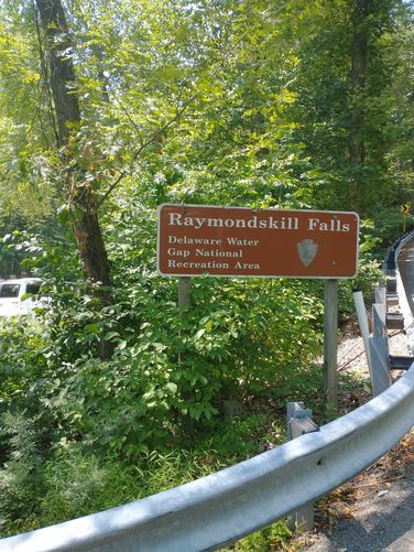
Raymondskill Falls Loop at Delaware Water Gap National Recreation Area near Milford, Pennsylvania is a moderate 0.4-mile loop hike that leads to Pennsylvania's tallest waterfall, Raymondskill Falls (150-feet).
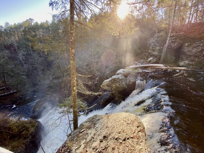
Raymondskill Falls
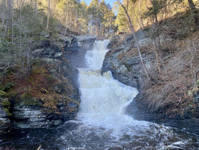
Note that Raymondskill Falls is a series of three waterfalls, totaling 150-feet tall. Combined, this is the largest waterfall in Pennsylvania.
Popularity
This is one of the most-popular trails at Delaware Water Gap National Recreation Area. You will likely see other hikers on this trail.
Hike Description
This hike begins at the eastern parking lot for Raymondskill Falls, located on the south side of Raymondskill Road and follows the trail as it heads into the forest. The trail heads downhill alongside super-steep ravine walls as it makes its way toward a viewpoint of Lower and Middle Raymondskill Falls. Along the way are several series of rock stairs before the trail splits to reach the viewpoint.
Lower and Middle Raymondskill Falls - Mile 0.15
At mile 0.15, hikers will reach a viewing platform for both Middle and Lower Raymondskill Falls. This viewing platform is by far the best view of the waterfalls along the entire hike. Raymondskill Falls is split into three tiers -- from this viewpoint, hikers can see the largest tier, Middle Raymondskill Falls which appears to be about 90-feet tall. From the edge of the creek / fence, hikers will get a view of Lower Raymondskill Falls which cascades down at about 55-feet tall. Across the creek is another waterfall that cascades down adjacent to Lower Raymondskill Falls, which provides hikers with a spectacular view.
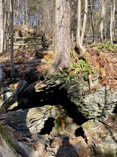
After taking in the scenery from Lower and Middle Falls, hikers will make their way up the rocky and root-filled path as its skirts around these super-steep ledges to make its way to the top of Middle Falls. Along the way is a neat cave that sits below an old hemlock tree -- the cave is damp with trickling water, likely filled with ice during the winter, and is large enough to fit a few adults (for size).
Top of Raymondskill Falls / Upper Falls View - Mile 0.25
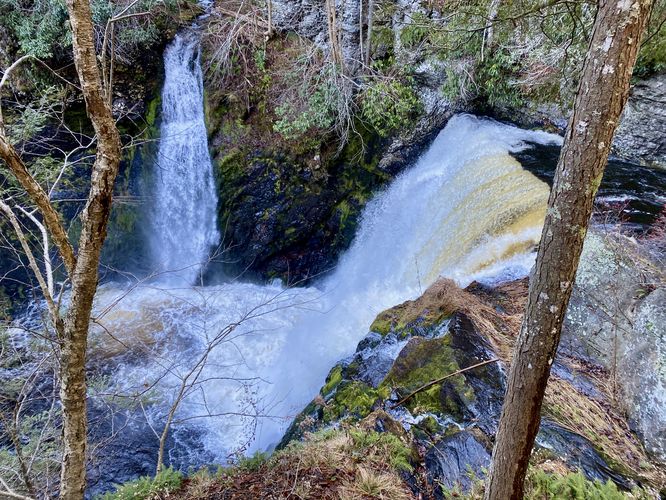
At mile 0.25, hikers will reach the top of Raymondskill Falls (technically the Middle tier of the entire cascade. From this viewing platform, you'll also be able to see the ~5-foot tall Upper Raymondskill Falls that cascades down the creek just upstream from the big cascade at your feet. Hikers can hang out here for a bit to enjoy the top of the massive cascade of Raymondskill Falls before heading back to parking.
From the top of Raymondskill Falls, hikers will head up the trail to reach the western parking lot. Once at the western parking lot, the trail heads due-east to continue the loop. The trail will then converge with the path you hiked in on from the eastern parking lot -- take a left-hand turn to reach your car and to complete the loop.
Parking
Hikers will find two parking lots -- one at the coordinates provided (eastern) and one just 200-feet to the west. Both are located along Raymondskill Road and both are large enough to fit about 15 vehicles each, max.
Pets
Dogs are not allowed on this trail.
Restrooms
As of December 2023, there are restrooms at the western parking lot.
Warning
Steep ledges: This trail follows extremely steep ledges, watch your step.
Dangerous winter conditions: Due to the steep drop-offs and ledges in addition to the winter's icy conditions, this trail can be dangerous during the winter. Hike at your own risk.
Raymondskill Falls
Note that Raymondskill Falls is a series of three waterfalls, totaling 150-feet tall. Combined, this is the largest waterfall in Pennsylvania.
Popularity
This is one of the most-popular trails at Delaware Water Gap National Recreation Area. You will likely see other hikers on this trail.
Hike Description
This hike begins at the eastern parking lot for Raymondskill Falls, located on the south side of Raymondskill Road and follows the trail as it heads into the forest. The trail heads downhill alongside super-steep ravine walls as it makes its way toward a viewpoint of Lower and Middle Raymondskill Falls. Along the way are several series of rock stairs before the trail splits to reach the viewpoint.
Lower and Middle Raymondskill Falls - Mile 0.15
At mile 0.15, hikers will reach a viewing platform for both Middle and Lower Raymondskill Falls. This viewing platform is by far the best view of the waterfalls along the entire hike. Raymondskill Falls is split into three tiers -- from this viewpoint, hikers can see the largest tier, Middle Raymondskill Falls which appears to be about 90-feet tall. From the edge of the creek / fence, hikers will get a view of Lower Raymondskill Falls which cascades down at about 55-feet tall. Across the creek is another waterfall that cascades down adjacent to Lower Raymondskill Falls, which provides hikers with a spectacular view.
After taking in the scenery from Lower and Middle Falls, hikers will make their way up the rocky and root-filled path as its skirts around these super-steep ledges to make its way to the top of Middle Falls. Along the way is a neat cave that sits below an old hemlock tree -- the cave is damp with trickling water, likely filled with ice during the winter, and is large enough to fit a few adults (for size).
Top of Raymondskill Falls / Upper Falls View - Mile 0.25
At mile 0.25, hikers will reach the top of Raymondskill Falls (technically the Middle tier of the entire cascade. From this viewing platform, you'll also be able to see the ~5-foot tall Upper Raymondskill Falls that cascades down the creek just upstream from the big cascade at your feet. Hikers can hang out here for a bit to enjoy the top of the massive cascade of Raymondskill Falls before heading back to parking.
From the top of Raymondskill Falls, hikers will head up the trail to reach the western parking lot. Once at the western parking lot, the trail heads due-east to continue the loop. The trail will then converge with the path you hiked in on from the eastern parking lot -- take a left-hand turn to reach your car and to complete the loop.
Parking
Hikers will find two parking lots -- one at the coordinates provided (eastern) and one just 200-feet to the west. Both are located along Raymondskill Road and both are large enough to fit about 15 vehicles each, max.
Pets
Dogs are not allowed on this trail.
Restrooms
As of December 2023, there are restrooms at the western parking lot.
Warning
Steep ledges: This trail follows extremely steep ledges, watch your step.
Dangerous winter conditions: Due to the steep drop-offs and ledges in addition to the winter's icy conditions, this trail can be dangerous during the winter. Hike at your own risk.