Loading...

🎉 Enjoy a Free 7-Day Supporter Trial and Unlock Exclusive Perks — No Credit Card Required. Learn more.

Raven Rocks via Appalachian Trail

Directions
Map
Pictures
Send to App
Distance:
5.1 Miles / 8.2 km
Type:
Out-and-Back
Difficulty:
Strenuous
Time to Hike:
2 hours, ~33 minutes
Features:
Appalachian Trail hike
Surface Type:
Dirt
Town:
Bluemont, Virginia
Directions:
39.116532, -77.852537
Added:
March 13, 2024
Updated:
March 18, 2024
Copy Trail Link Hiking this trail? Send a friend or family member a link to this trail guide for your own safety. Hike at your own risk (disclaimer)
Loading...
Loading...
425'

Total Change
1,671'

Ascent
1,661'

Descent

Download the Trail Route for Offline Use

Supporters get exclusive access to download trail routes to the MyHikes app for offline use. Stay prepared on your adventure, even without an internet connection! Become a Supporter today to unlock this feature and hike with confidence.

Send to App

Raven Rocks via Appalachian Trail

Raven Rocks via Appalachian Trail is a strenuous 5.1-mile out-and-back hike that features stunning views from Raven Rocks.

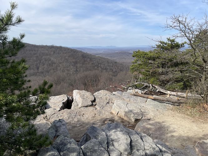
The view from Raven Rocks is one of the best in the area. At a total distance of 5.1 miles there are three strenuous ascents on this out and back hike. Raven Rocks is also a popular area with rock climbers, as the wall can be accessed by a road 0.4 miles from the east. Make sure to wear good footwear. A hiking stick or poles are also recommended.

Trails
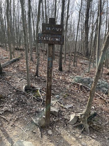
This hike follows two named trails along the same exact route: Raven Rocks Trail, Appalachian Trail (white blazes).

Parking
Hikers will find parking along the east side of Pine Grove Road in Bluemont, VA.

Pets
Dogs are allowed only if leashed and must be cleaned up after.

Camping & Backpacking
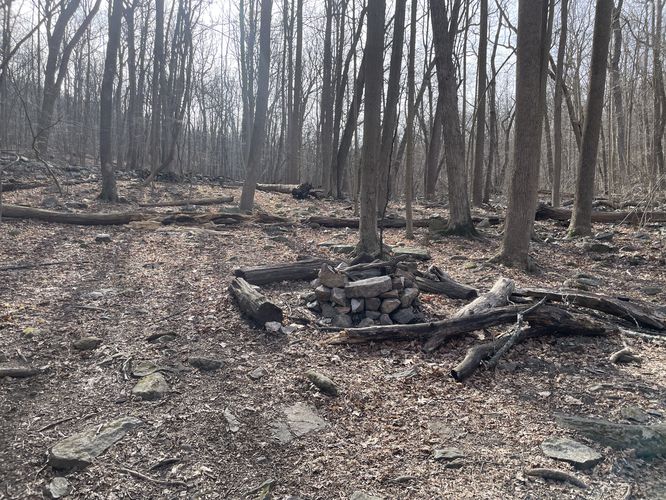
Backpacking and camping is permitted along the Appalachian Trail. Along this hike is a campsite, located around mile 2. The campsite sits along Raven Rocks Hollow which features a nearby creek to filter water from.
Explore 38 trails near Bluemont, VA
  1. Parking

    39.116532, -77.852537
  2. Main Trailhead

    39.116362, -77.852034
  3. WV/VA state line

    39.140328, -77.840103
    WV/VA state line
  4. Campsite

    39.136856, -77.842231
    Campsite
  5. Raven Rocks

    39.139317, -77.837861
    Raven Rocks
No community routes found. To add your own hike as a Community Route for this Trail guide, leave a Trip Report with an attached GPX file.

Hazards

Ticks - Lyme Disease More Info (CDC)
Snakes
Poison Ivy/Oak

Seasons

All

Blaze Color

White

Weather Forecast

In Bluemont, VA

Explore Hiking Trails

You May Also Like

New York's Best Waterfalls - Whether you're planning a day hike, roadside stop, or a leisurely short walk, this guide provides hikers, travelers, and locals alike with 63 different locations to over 100 scenic waterfalls to help plan your next adventure!
Explore

New York's Best Waterfalls

Whether you're planning a day hike, roadside stop, or a leisurely short walk, this guide provides hikers, travelers, and locals alike with 63 different locations to over 100 scenic waterfalls to help plan your next adventure!

Read
25 Best Day Hikes in North Carolina - Discover the top 25 best day hikes in North Carolina, from breathtaking waterfalls to mountain peaks. Explore hidden gems, scenic views, and trails suitable for all skill levels, perfect for your next outdoor adventure.
Explore

25 Best Day Hikes in North Carolina

Discover the top 25 best day hikes in North Carolina, from breathtaking waterfalls to mountain peaks. Explore hidden gems, scenic views, and trails suitable for all skill levels, perfect for your next outdoor adventure.

Read

Before you boogie...

Find our trail guides useful? Consider becoming a Supporter to unlock perks!

MyHikes is an indie platform that makes exploring public trails easier for everyone. The platform has no investors, no ads, and is owned and operated by one person, Dave Miller. Dave has personally mapped and written over 1,800 trail guides on MyHikes for the public to explore. MyHikes has helped millions outdoor enthusiasts plan their next adventure.

But it takes a lot of time 🕦, money 💰, work, and espresso shots ☕ to run MyHikes, including hiking , mapping , writing , and publishing new trails with high-quality (accurate) information... along with software engineering (coding) the platform like building new features, website and mobile app development (iOS and Android), site maintainance . and much much more.

Supporters unlock website and mobile app perks with an annual one-time payment of $25 (you renew) 😎👍. Or you can simply make a Donation of your choice. Otherwise, you can support us by telling your friends about MyHikes - both quick and free 🎉

Admin user profile picture

Dave Miller
MyHikes Founder