The Racehorse Falls Trail near Kendall, Washington is an easy 0.7-mile out-and-back hike that leads to the scenic, but dangerous Racehorse Falls.
Hiking Out - Mile 0.36 to 0.7 After exploring the scenery of Racehorse Falls, the hike back to parking is straight forward. Simply take the trail back through the lush jungle-like vegetation of moss-covered trees and massive ferns. Return to the parking area at mile 0.7 to wrap up the hike.
Cougars: This area is home to the cougar / mountain lion and this terrain is perfect for them to live in as they love steep gorges, ravines, and overgrowth. Be aware of your surroundings, hike with another person, make noise while hiking, and keep any small children close to you for safety. While running into cougars may be rare, it does happen and thankfully attacks on humans is even more rare.
Hike to Racehorse Falls
This hike begins on the south side of North Fork Road where you'll find an unmarked trailhead at the coordinates provided. The Racehorse Falls Trail leads through the lush forest as it leads south toward Racehorse Creek. Along the way, hikers will find vibrant moss-covered trees, massive ferns, and decaying old-growth stumps. Some sections of the trail can be a bit overgrown, but the overgrowth isn't all that much to deal with.Steep Hill to Lower Racehorse Falls - Mile 0.3 to 0.33
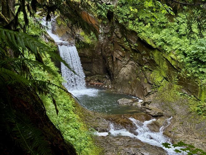
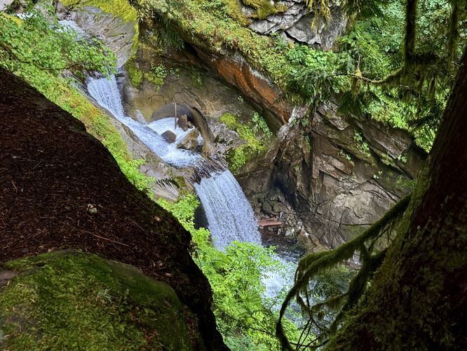
Hikers will reach a junction in the trail around mile 0.3 where you'll find a very-steep dirt path that leads down to the sheer cliffs that surround the creek. If you wish to view the lower section of Racehorse Falls, which is arguably the best view of the main waterfall, consider taking this trail down to the viewpoint. Be extremely careful if you take this path as the terrain has a steep elevation grade and can be slippery. One false move and you might fall over the cliff which will result in injury if not death. The view of Racehorse Falls from the cliff's edge is unmatched here, which is unfortunate due to the danger involved in reaching it. For a less-dangerous, but still sketchy view, check out the viewpoint located just up the trail.Racehorse Falls Viewpoint - Mile 0.36
Either hike back uphill to the junction or skip the steep downhill to head east to reach the main overlook above Racehorse Falls. Here, the view of the waterfall is more of a top-down view of the plummeting cascade and at least one slide waterfall that's carved its way through the bedrock above. Again, this is a sheer cliff and you must be extremely careful if you plan to take photographs of Racehorse Falls from the edge.Hiking Out - Mile 0.36 to 0.7 After exploring the scenery of Racehorse Falls, the hike back to parking is straight forward. Simply take the trail back through the lush jungle-like vegetation of moss-covered trees and massive ferns. Return to the parking area at mile 0.7 to wrap up the hike.
Parking & Fees
Hikers will find a small parking turnout on the south side of North Fork Road, Whatcom Washington at the coordinates provided. A Discover Pass is required to park and use the land here as it's owned, managed, and operated by Washington State Forest.Pets
Dogs are allowed only if leashed and must be cleaned up after.Warning
Steep cliffs and terrain: This hike leads down steep terrain that can often be wet and slippery. The steep terrain leads to viewpoints and overlooks of Racehorse Creek where you'll find Racehorse Falls sitting at the very bottom of the ravine that surrounds the creek. This terrain can be extremely dangerous, espcially when wet. Using trekking poles will not only aid in your hike here, but should keep you a bit safer to provide extra support when traversing the steep hillsides. Stand back from the cliffs for your own safety and always watch your step.Cougars: This area is home to the cougar / mountain lion and this terrain is perfect for them to live in as they love steep gorges, ravines, and overgrowth. Be aware of your surroundings, hike with another person, make noise while hiking, and keep any small children close to you for safety. While running into cougars may be rare, it does happen and thankfully attacks on humans is even more rare.