Loading...

🎉 Enjoy a Free 7-Day Supporter Trial and Unlock Exclusive Perks — No Credit Card Required. Learn more.

Race Brook Falls - Lower Falls

Directions
Map
Pictures
Send to App
Distance:
1.3 Miles / 2.1 km
Type:
Out-and-Back
Difficulty:
Moderate
Time to Hike:
~39 minutes
Features:
Surface Type:
Dirt
Town:
Sheffield, Massachusetts
Directions:
42.089446, -73.411209
Added:
August 01, 2021
Updated:
August 02, 2021
Copy Trail Link Hiking this trail? Send a friend or family member a link to this trail guide for your own safety. Hike at your own risk (disclaimer)
Loading...
Loading...
361'

Total Change
428'

Ascent
417'

Descent

Download the Trail Route for Offline Use

Supporters get exclusive access to download trail routes to the MyHikes app for offline use. Stay prepared on your adventure, even without an internet connection! Become a Supporter today to unlock this feature and hike with confidence.

Send to App

Race Brook Falls - Lower Falls

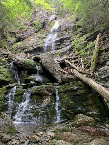
The Race Brook Falls - Lower Falls hike at Mount Everett State Reservation near Sheffield, Massachusetts is a moderate 1.3-mile out-and-back trek that leads to a ~80-foot tall waterfall, Lower Race Brook Falls.

Trails: This hike follows two named trails: Race Brook Falls Trail, Lower Falls Trails.

Hike Description: Hikers will begin following the Race Brook Falls Trail at the parking lot before taking a right-hand turn at the Lower Falls Trail around mile 0.25. From here, hikers will follow the Lower Falls Trail right to the base of the 80-foot tall Lower Race Brook Falls.

Parking: Hikers will find parking directly off Route 41 in a small pull-off at the coordinates provided.

Blaze Colors: This hike follows blue blazes.
Explore 11 trails near Sheffield, MA
  1. Parking

    42.089446, -73.411209
  2. Main Trailhead

    42.089346, -73.411436
  3. 80-foot tall Race Brook Falls - Lower Falls

    42.089558, -73.421561
    80-foot tall Race Brook Falls - Lower Falls
No community routes found. To add your own hike as a Community Route for this Trail guide, leave a Trip Report with an attached GPX file.

Hazards

Ticks - Lyme Disease More Info (CDC)
Rockfalls / Ledges / or Scrambles

Seasons

All

Blaze Color

Blue

Weather Forecast

In Sheffield, MA

Explore Hiking Trails

You May Also Like

Colorado's Million Dollar Highway - Plan a day's drive adventure along the iconic Million Dollar Highway in Colorado. Explore the best short trails, roadside stops, waterfalls, vistas, ghost towns, and hot springs within a ~6 hour road trip.
Explore

Colorado's Million Dollar Highway

Plan a day's drive adventure along the iconic Million Dollar Highway in Colorado. Explore the best short trails, roadside stops, waterfalls, vistas, ghost towns, and hot springs within a ~6 hour road trip.

Read
Glacier's Going-to-the-Sun Road - Discover the breathtaking beauty of Glacier National Park along the iconic Going-to-the-Sun Road. From stunning roadside stops to picturesque waterfalls and vistas, this engineering marvel offers endless opportunities for exploration.
Explore

Glacier's Going-to-the-Sun Road

Discover the breathtaking beauty of Glacier National Park along the iconic Going-to-the-Sun Road. From stunning roadside stops to picturesque waterfalls and vistas, this engineering marvel offers endless opportunities for exploration.

Read
New York's Best Waterfalls - Whether you're planning a day hike, roadside stop, or a leisurely short walk, this guide provides hikers, travelers, and locals alike with 63 different locations to over 100 scenic waterfalls to help plan your next adventure!
Explore

New York's Best Waterfalls

Whether you're planning a day hike, roadside stop, or a leisurely short walk, this guide provides hikers, travelers, and locals alike with 63 different locations to over 100 scenic waterfalls to help plan your next adventure!

Read

Before you boogie...

Find our trail guides useful? Consider becoming a Supporter to unlock perks!

MyHikes is an indie platform that makes exploring public trails easier for everyone. The platform has no investors, no ads, and is owned and operated by one person, Dave Miller. Dave has personally mapped and written over 1,800 trail guides on MyHikes for the public to explore. MyHikes has helped millions outdoor enthusiasts plan their next adventure.

But it takes a lot of time 🕦, money 💰, work, and espresso shots ☕ to run MyHikes, including hiking , mapping , writing , and publishing new trails with high-quality (accurate) information... along with software engineering (coding) the platform like building new features, website and mobile app development (iOS and Android), site maintainance . and much much more.

Supporters unlock website and mobile app perks with an annual one-time payment of $25 (you renew) 😎👍. Or you can simply make a Donation of your choice. Otherwise, you can support us by telling your friends about MyHikes - both quick and free 🎉

Admin user profile picture

Dave Miller
MyHikes Founder