Quarry Road Trail to American Canyon
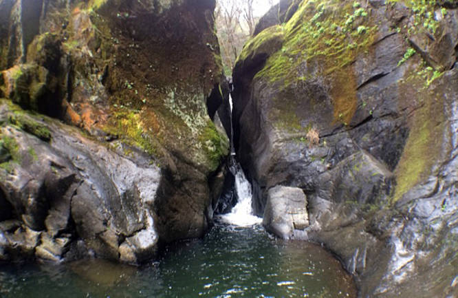
It’s a wide dirt path that is perfect for trail running, easy mountain biking or hiking. It’s also dog and horse friendly. Follow the American Canyon Trail another mile to some small waterfalls and a deep little hidden pool.
For more details, check out the Norcalhiker Blog post for this trail.
Know Before You Go
Interactive topographic map for Quarry Road Trail to American Canyon located in Cool, CA. Click the "View Map" button to load GPS coordinates and trail markers.
View map
Get directions
- Distance
- 13.5 mi
- Difficulty
- Moderate
- Type
- Out-and-Back
- Est. Time
- 6.8 hrs
- Elev. Gain
- 1,210'
- Rating
- 0.0
- Added
- February 17, 2017
- Updated
- May 21, 2018
Weather Forecast
Tonight
Low
71°F
Clear
Monday
High
101°F
Sunny
Monday Night
Low
72°F
Clear
Tuesday
High
100°F
Sunny
Tuesday Night
Low
67°F
Clear
Wednesday
High
97°F
Sunny
Wednesday Night
Low
67°F
Clear
Thursday
High
99°F
Sunny
Thursday Night
Low
68°F
Clear
Friday
High
100°F
Sunny
Friday Night
Low
71°F
Clear
Saturday
High
100°F
Sunny
Saturday Night
Low
70°F
Clear
Sunday
High
97°F
Sunny
Don't let Google decide who you trust.


Loading...
<strong>Trail map and elevation chart not rendering in print mode?</strong> Simply scroll to the trail map section, then try printing again!
Total Change
365 ft.
111 m
111 m
Ascent
1,210 ft.
369 m
369 m
Descent
1,254 ft.
382 m
382 m
Loading...
Features
- Dogs
- Waterfalls
- Water Source
- Biking
Points of interest
-
Parking
38.912307, -121.03569 -
Main Trailhead
38.911996, -121.035076 -
Waterfall
38.932603, -120.940736
Safety information
For your own safety: plan ahead, let someone know where you'll be, and hike at your own risk.
Availability
Summer
Surface type
Dirt
Trip Reports (Reviews)
Ready to help fellow hikers? Add a trip report to share your experience!
No community routes found. To add your own hike as a Community Route for this Trail guide, leave a Trip Report with an attached GPX file.


You may also like

Explore
Best of the Alps: Hiking, Adventure & Scenery
Plan your ultimate European Alps adventure! Discover the best hiking trails, epic scenery, and villages in the Swiss Alps, Dolomites, Chamonix, and Lake Como.

Explore
Colorado's Million Dollar Highway
Plan a day's drive adventure along the iconic Million Dollar Highway in Colorado. Explore the best short trails, roadside stops, waterfalls, vistas, ghost towns, and hot springs within a ~6 hour road trip.

Explore
Glacier's Going-to-the-Sun Road
Discover the breathtaking beauty of Glacier National Park along the iconic Going-to-the-Sun Road. From stunning roadside stops to picturesque waterfalls and vistas, this engineering marvel offers endless opportunities for exploration.

Explore
Hike Washington's National Parks & Forests
Find the best day hikes in Washington's National Parks and Forests. Explore panoramic alpine vistas, turquoise lakes, and stunning waterfalls.
auburn state recreational area

