Gate 30
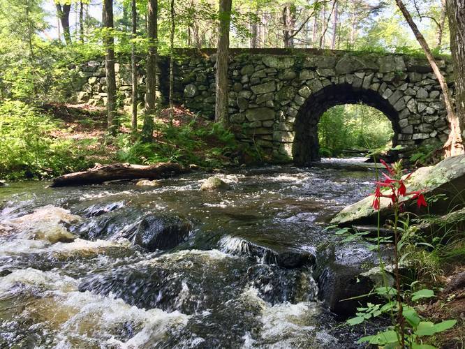
The trail is most popular for the stone bridge that passes over a creek that feeds into Quabbin, which can be found just a hundred feet from the trailhead. During the Summer you can often find Fire Pink flowers lining the banks of the creek.
The trail itself continues much further than 0.4 miles one-way, but there's not much to see as the service road does not meet the water.
Pets
Dogs are not allowed on any trails at Quabbin.
Know Before You Go
Interactive topographic map for Gate 30 located in New Salem, MA. Click the "View Map" button to load GPS coordinates and trail markers.
View map
Get directions
- Distance
- 0.8 mi
- Difficulty
- Easy
- Type
- Out-and-Back
- Est. Time
- 24 min
- Elev. Gain
- 46'
- Rating
- 0.0
- Added
- August 05, 2018
- Updated
- April 27, 2020
Weather Forecast
Tonight
Low
52°F
Smoke then Partly Cloudy
Friday
High
82°F
Sunny
Friday Night
Low
53°F
Partly Cloudy
Saturday
High
83°F
Chance Rain Showers then Chance Showers And Thunderstorms
Saturday Night
Low
64°F
Showers And Thunderstorms
Sunday
High
81°F
Mostly Sunny
Sunday Night
Low
55°F
Clear
Monday
High
82°F
Sunny
Monday Night
Low
60°F
Partly Cloudy
Tuesday
High
81°F
Chance Rain Showers then Chance Showers And Thunderstorms
Tuesday Night
Low
63°F
Chance Showers And Thunderstorms then Showers And Thunderstorms Likely
Wednesday
High
79°F
Rain Showers Likely
Wednesday Night
Low
60°F
Chance Showers And Thunderstorms
Thursday
High
79°F
Mostly Sunny then Slight Chance Showers And Thunderstorms
Don't let Google decide who you trust.


Loading...
<strong>Trail map and elevation chart not rendering in print mode?</strong> Simply scroll to the trail map section, then try printing again!
Total Change
46 ft.
14 m
14 m
Ascent
46 ft.
14 m
14 m
Descent
40 ft.
12 m
12 m
Loading...
Features
- Water Source
Points of interest
-
Parking
42.534769, -72.302 -
Main Trailhead
42.534413, -72.302172 -
Water Source / Water Crossing
42.534039, -72.302742
Safety information
For your own safety: plan ahead, let someone know where you'll be, and hike at your own risk.
Availability
All seasons
Surface type
Dirt
Trip Reports (Reviews)
Ready to help fellow hikers? Add a trip report to share your experience!
No community routes found. To add your own hike as a Community Route for this Trail guide, leave a Trip Report with an attached GPX file.


You may also like

Explore
Best of the Alps: Hiking, Adventure & Scenery
Plan your ultimate European Alps adventure! Discover the best hiking trails, epic scenery, and villages in the Swiss Alps, Dolomites, Chamonix, and Lake Como.

Explore
Colorado's Million Dollar Highway
Plan a day's drive adventure along the iconic Million Dollar Highway in Colorado. Explore the best short trails, roadside stops, waterfalls, vistas, ghost towns, and hot springs within a ~6 hour road trip.

Explore
Glacier's Going-to-the-Sun Road
Discover the breathtaking beauty of Glacier National Park along the iconic Going-to-the-Sun Road. From stunning roadside stops to picturesque waterfalls and vistas, this engineering marvel offers endless opportunities for exploration.

Explore
Hike Washington's National Parks & Forests
Find the best day hikes in Washington's National Parks and Forests. Explore panoramic alpine vistas, turquoise lakes, and stunning waterfalls.
quabbin reservoir

