The Putney Mountain Loop at Putney Town Forest in Putney, Vermont is an easy 1.3-mile loop hike that leads to the summit of Putney Mountain and features views of its surrounding mountains.
Trails
This hike follows two named trails in a counter-clockwise loop: Ridgeline Trail, West Cliff Trail (yellow blazes).
Hiking the Putney Mountain Loop
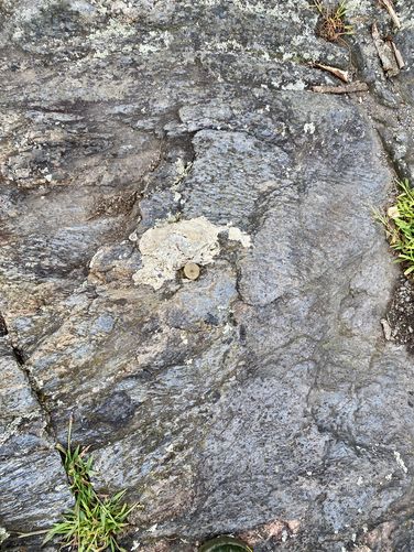
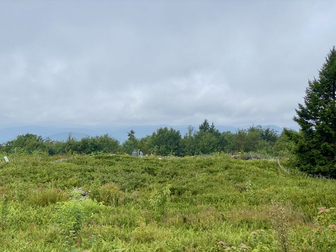
This hike begins at the main trailhead for Putney Mountain and the Putney Town Forest, located at the end of a dead-end dirt entrance road. We hiked this counter-clockwise, but both directions should be considered easy difficulty for the average hiker. The first trail is the Ridgeline Trail which, as the name suggests, runs the ridge line of Putney Mountain heading north. The trail is easy to follow but can be very muddy after recent rainfall. Not long after getting used to the trail's easy grade, it ascends up Putney Mountain to reach the summit following a moderate but short grade from mile 0.45 to 0.55 for just one-tenth of a mile. At the top of Putney Mountain, hikers will find plateau-like views of the surrounding mountain tops of southern Vermont. The best views are to the west, which provide views of some of the closer mountain tops. During our hike here in August 2024, we unfortunately were stuck in the clouds at the top of the mountain, so the views weren't as nice as they could've been. The true summit of Putney Mountain is marked with a metal pin that was drilled and cemented into the bedrock at its highest point. The trail then leads west as it meanders the top of the mountain, passing through low-growing bushes like blueberry, before it winds its way out from the top and down the West Cliff Trail, following yellow blaze markers. The West Cliff Trail can also be very muddy after a recent rainfall, but passes through beautiful sections of evergreen (mostly Eastern Hemlock) forests. The West Cliff Trail leads back to parking, but not before ascending a short ~30-foot ascent to reach the trailhead.
Parking
Hikers will find a dirt road that leads off of the north side of Putney Mountain Road at the coordinates provided (42.996099, -72.598444) which is a dead end and includes parking along the way. As of August 2024, there's enough parking to fit over a dozen vehicles.
Pets
Dogs are allowed only if leashed and must be cleaned up after.
Trails
This hike follows two named trails in a counter-clockwise loop: Ridgeline Trail, West Cliff Trail (yellow blazes).
Hiking the Putney Mountain Loop
This hike begins at the main trailhead for Putney Mountain and the Putney Town Forest, located at the end of a dead-end dirt entrance road. We hiked this counter-clockwise, but both directions should be considered easy difficulty for the average hiker. The first trail is the Ridgeline Trail which, as the name suggests, runs the ridge line of Putney Mountain heading north. The trail is easy to follow but can be very muddy after recent rainfall. Not long after getting used to the trail's easy grade, it ascends up Putney Mountain to reach the summit following a moderate but short grade from mile 0.45 to 0.55 for just one-tenth of a mile. At the top of Putney Mountain, hikers will find plateau-like views of the surrounding mountain tops of southern Vermont. The best views are to the west, which provide views of some of the closer mountain tops. During our hike here in August 2024, we unfortunately were stuck in the clouds at the top of the mountain, so the views weren't as nice as they could've been. The true summit of Putney Mountain is marked with a metal pin that was drilled and cemented into the bedrock at its highest point. The trail then leads west as it meanders the top of the mountain, passing through low-growing bushes like blueberry, before it winds its way out from the top and down the West Cliff Trail, following yellow blaze markers. The West Cliff Trail can also be very muddy after a recent rainfall, but passes through beautiful sections of evergreen (mostly Eastern Hemlock) forests. The West Cliff Trail leads back to parking, but not before ascending a short ~30-foot ascent to reach the trailhead.
Parking
Hikers will find a dirt road that leads off of the north side of Putney Mountain Road at the coordinates provided (42.996099, -72.598444) which is a dead end and includes parking along the way. As of August 2024, there's enough parking to fit over a dozen vehicles.
Pets
Dogs are allowed only if leashed and must be cleaned up after.