Putney Mountain Falls within Putney Town Forest in Putney, Vermont is a multi-tiered 40-foot tall waterfall that can be accessed via an easy roadside walk.
Exploring Putney Mountain Falls
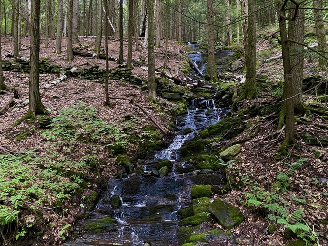
This short walk along Putney Mountain Road leads to the multi-tiered 40-foot waterfall that cascades down the side of Putney Mountain's western slopes. The waterfall sits about 200-feet up the road from the parking turnout, so visitors can carefully walk the forest road to reach the base of the waterfall. Putney Mountain Falls cascades down a series of bedrock tiers with a flow best viewed after a rainfall. The total height of the waterfall is about 40-feet tall or slightly higher, if you include all of the tiers of bedrock visible from the road.
Universal Access
Since no walking is required to enjoy Putney Mountain Falls, this waterfall should be considered universally accessible as you can enjoy it from the roadside in your vehicle which might be safer than road walking. Note that the parking turnout is not universally accessible nor is the forest road.
Parking
Visitors will find a very-small parking turnout located at the coordinates provided (), on the north side of Putney Mountain Road that can fit approximately 2 vehicles, max as of August 2024.
Pets
Dogs are allowed if leashed and should be cleaned up after.
Warning
Road walking: To enjoy this waterfall outside of your vehicle, you must walk the forest road which includes some blind bends in the road. Be on the lookout for oncoming traffic and walk the road at your own risk.
Exploring Putney Mountain Falls
This short walk along Putney Mountain Road leads to the multi-tiered 40-foot waterfall that cascades down the side of Putney Mountain's western slopes. The waterfall sits about 200-feet up the road from the parking turnout, so visitors can carefully walk the forest road to reach the base of the waterfall. Putney Mountain Falls cascades down a series of bedrock tiers with a flow best viewed after a rainfall. The total height of the waterfall is about 40-feet tall or slightly higher, if you include all of the tiers of bedrock visible from the road.
Universal Access
Since no walking is required to enjoy Putney Mountain Falls, this waterfall should be considered universally accessible as you can enjoy it from the roadside in your vehicle which might be safer than road walking. Note that the parking turnout is not universally accessible nor is the forest road.
Parking
Visitors will find a very-small parking turnout located at the coordinates provided (), on the north side of Putney Mountain Road that can fit approximately 2 vehicles, max as of August 2024.
Pets
Dogs are allowed if leashed and should be cleaned up after.
Warning
Road walking: To enjoy this waterfall outside of your vehicle, you must walk the forest road which includes some blind bends in the road. Be on the lookout for oncoming traffic and walk the road at your own risk.