The Pulpit Falls Trail in Winchester, New Hampshire is an easy 0.7-mile out-and-back hike that leads to the scenic 8-foot tall cascade known as Pulpit Falls.
Hike
This hike begins at a discrete trailhead located on the south side of NH-10 at the coordinates provided. The trail leads into the forest and heads downhill immediately along an easy-grade trail. During our hike here in July 2024, we found the trail was covered in wood chips and appears to have been recently used as a logging path.
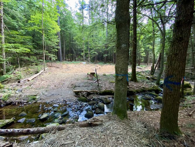
Creek Crossing / Left-Hand Turn - Mile 0.13
At the bottom of the hill, hikers will find a creek that flows from west to east. Here, you can choose to hike across the creek first and take a left-hand turn at the blue blazes to continue following the trail. Alternatively, you can take a left-hand turn into the woods before the creek, cross the creek, and continue.
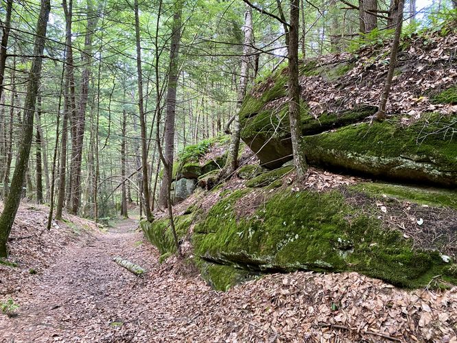
After passing the creek, the trail leads uphill passing a large rock outcropping. This rock is covered in moss and creates a scenic look and feel along the trail. Not long after that, the trail will lead back downhill to reach Pulpit Falls, located around mile 0.37.
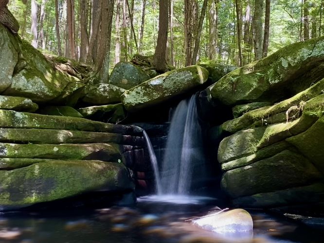
Pulpit Falls - Mil 0.37
Hikers will reach Pulpit Falls around mile 0.37 in the route provided. Pulpit Falls cascades down the bedrock to reach a scenic pool of water just below the 8-foot free-falling plunge. Hikers can head down the bedrock to get better views of the waterfall. If you want to explore further, you can find a nice downstream view of the cascade from ~100-feet downstream.
Hiking Out - Mile 0.37 to 7
The hike out follows the same path but leads mostly uphill the entire way. Despite the elevation gain, this hike should be considered easy as the uphill climbs don't last very long.
Parking
Hikers will find parking turnouts by the coordinates provided, located along NH-10. There are turnouts on either side of the road and can hold a handful of vehicles as of July 2024.
Pets
Dogs are allowed if leashed and should be cleaned up after.
Warning
Buggy: This trail can be very buggy during warm months.
Hike
This hike begins at a discrete trailhead located on the south side of NH-10 at the coordinates provided. The trail leads into the forest and heads downhill immediately along an easy-grade trail. During our hike here in July 2024, we found the trail was covered in wood chips and appears to have been recently used as a logging path.
Creek Crossing / Left-Hand Turn - Mile 0.13
At the bottom of the hill, hikers will find a creek that flows from west to east. Here, you can choose to hike across the creek first and take a left-hand turn at the blue blazes to continue following the trail. Alternatively, you can take a left-hand turn into the woods before the creek, cross the creek, and continue.
After passing the creek, the trail leads uphill passing a large rock outcropping. This rock is covered in moss and creates a scenic look and feel along the trail. Not long after that, the trail will lead back downhill to reach Pulpit Falls, located around mile 0.37.
Pulpit Falls - Mil 0.37
Hikers will reach Pulpit Falls around mile 0.37 in the route provided. Pulpit Falls cascades down the bedrock to reach a scenic pool of water just below the 8-foot free-falling plunge. Hikers can head down the bedrock to get better views of the waterfall. If you want to explore further, you can find a nice downstream view of the cascade from ~100-feet downstream.
Hiking Out - Mile 0.37 to 7
The hike out follows the same path but leads mostly uphill the entire way. Despite the elevation gain, this hike should be considered easy as the uphill climbs don't last very long.
Parking
Hikers will find parking turnouts by the coordinates provided, located along NH-10. There are turnouts on either side of the road and can hold a handful of vehicles as of July 2024.
Pets
Dogs are allowed if leashed and should be cleaned up after.
Warning
Buggy: This trail can be very buggy during warm months.