Loading...

🎉 Enjoy a Free 7-Day Supporter Trial and Unlock Exclusive Perks — No Credit Card Required. Learn more.

Prince William Forest Hike

Directions
Map
Pictures
Send to App
Distance:
7.0 Miles / 11.3 km
Type:
Loop
Difficulty:
Moderate
Time to Hike:
3 hours, ~30 minutes
Features:
Surface Type:
Dirt
Town:
Triangle, Virginia
Directions:
38.58247, -77.373354
Added:
April 03, 2025
Updated:
April 06, 2025
Copy Trail Link Hiking this trail? Send a friend or family member a link to this trail guide for your own safety. Hike at your own risk (disclaimer)
Loading...
Loading...
213'

Total Change
701'

Ascent
702'

Descent

Download the Trail Route for Offline Use

Supporters get exclusive access to download trail routes to the MyHikes app for offline use. Stay prepared on your adventure, even without an internet connection! Become a Supporter today to unlock this feature and hike with confidence.

Send to App

Prince William Forest Hike

The Prince William Forest Park established in 1936 has 37 miles of trails on it's 15,000+ acres, and is the largest protected natural area in the Washington, D.C., metropolitan region. The circuit hike we have mapped here is just one of many possible combinations in it's vast trail system.

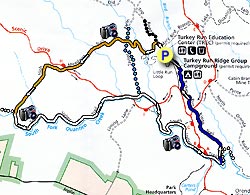
From the parking area start up Black Top Road (path) for 0.2 miles before turning left on the orange blazed High Meadows Trail. The parks trail junctions are marked by concrete posts similar to the posts used in the Shenandoah National Park.

Follow the High Meadows Trail for 0.2 miles before crossing the first of many small streams over a wooden footbridge. Immediately after crossing the footbridge turn right at the concrete post, and trail junction, continuing along the orange blazed High Meadows Trail. In 0.2 miles cross over the blue blazed Taylor Farm Road (path) staying on the orange blazed trail. In 100 yards pass a very small cemetery on your left.

Follow the orange blazed High Meadows Trail for another 1.0 miles and cross Scenic Drive. From the other side of the road the High Meadows Trail continues for 0.8 miles where it ends the junction of the South Valley Trail and south fork of Quantico Creek. The concrete post trail markings at this junction are confusing, just continue straight on the now white blazed South Valley Trail, shortly turning left up wooden stairs then continuing along the left bank of the creek for 1.7 miles before re-crossing Scenic Drive.

In 0.1 miles past the road pass the Taylor Farm Road Trail on your left, then going underneath Scenic Drive in another 0.2 miles. Continue along the white blazed trail following the stream for 0.3 miles where the trail ascends a small hill for the steepest part of the hike. The remaining section of the white blazed South Valley Trail is the busiest portion of the hike as the trail is easily accessible from three parking areas on Scenic Drive.

In 0.7 miles the white blazed trail crosses Scenic Drive again, and in 200 yards, and just before a small wooden footbridge, turn left on the blue blazed trail. There is no concrete trail post here. Immediately turn left uphill on the blue blazed Turkey Run Ridge Trail. In 0.6 miles cross Scenic Drive for the last time and follow the blue blazed trail for the remaining 0.7 miles back to the Turkey Run Education Center and parking area.

Explore 13 trails near Triangle, VA
  1. Parking

    38.58247, -77.373354
  2. Main Trailhead

    38.582174, -77.372975
No community routes found. To add your own hike as a Community Route for this Trail guide, leave a Trip Report with an attached GPX file.

Hazards

Ticks - Lyme Disease More Info (CDC)
Snakes
Poison Ivy/Oak

Seasons

All

Trip Reports

Trail Guide By:
HikingUpward user profile picture
7.0 miles / 11.3 km

Weather Forecast

In Triangle, VA

Explore Hiking Trails

You May Also Like

New York's Best Waterfalls - Whether you're planning a day hike, roadside stop, or a leisurely short walk, this guide provides hikers, travelers, and locals alike with 63 different locations to over 100 scenic waterfalls to help plan your next adventure!
Explore

New York's Best Waterfalls

Whether you're planning a day hike, roadside stop, or a leisurely short walk, this guide provides hikers, travelers, and locals alike with 63 different locations to over 100 scenic waterfalls to help plan your next adventure!

Read
25 Best Day Hikes in North Carolina - Discover the top 25 best day hikes in North Carolina, from breathtaking waterfalls to mountain peaks. Explore hidden gems, scenic views, and trails suitable for all skill levels, perfect for your next outdoor adventure.
Explore

25 Best Day Hikes in North Carolina

Discover the top 25 best day hikes in North Carolina, from breathtaking waterfalls to mountain peaks. Explore hidden gems, scenic views, and trails suitable for all skill levels, perfect for your next outdoor adventure.

Read

Before you boogie...

Find our trail guides useful? Consider becoming a Supporter to unlock perks!

MyHikes is an indie platform that makes exploring public trails easier for everyone. The platform has no investors, no ads, and is owned and operated by one person, Dave Miller. Dave has personally mapped and written over 1,800 trail guides on MyHikes for the public to explore. MyHikes has helped millions outdoor enthusiasts plan their next adventure.

But it takes a lot of time 🕦, money 💰, work, and espresso shots ☕ to run MyHikes, including hiking , mapping , writing , and publishing new trails with high-quality (accurate) information... along with software engineering (coding) the platform like building new features, website and mobile app development (iOS and Android), site maintainance . and much much more.

Supporters unlock website and mobile app perks with an annual one-time payment of $25 (you renew) 😎👍. Or you can simply make a Donation of your choice. Otherwise, you can support us by telling your friends about MyHikes - both quick and free 🎉

Admin user profile picture

Dave Miller
MyHikes Founder