The Presque Isle River Waterfalls Loop at Porcupine Mountains Wilderness State Park near Wakefield, Michigan is a moderate 3-mile loop hike that features three large waterfalls, Manabezho Falls, Manido Falls, and Nawadaha Falls.
Trails
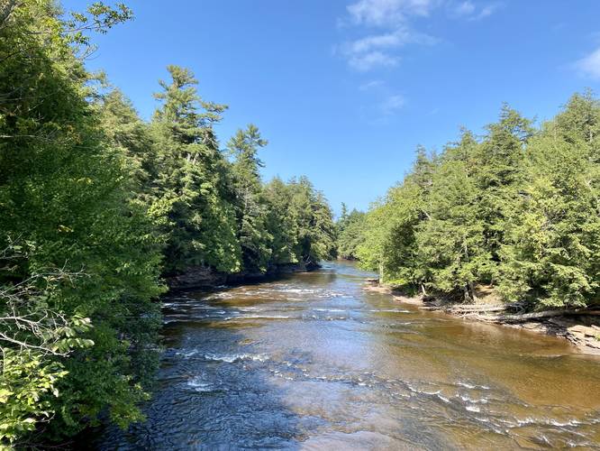
This hike follows several named trails that make up the loop in a counter-clockwise order: West River Trail / North Country Trail, East River Trail. Hikers will also have to walk along South Boundary Road to connect the West River Trail to the East River Trail to complete the loop. Please note that during high water, usually early Spring, the northern-most section of the East River Trail crosses Presque Isle River may flood the trail, since the trail technically crosses the river's bedrock in this area. During late Summer, this section is completely dry.
Hike Description
This hike begins at the northern-most parking lot for the waterfall loop and follows a flat path that leads north toward a series of stairs. Once at the stairs, the loop begins just at the bottom. This recording takes a right-hand turn to experienced the waterfalls from the western side of Presque Isle River before venturing down its eastern banks by following the West River Trail / North Country Trail. The trail will follow plenty of boardwalk areas throughout the western side of the river, making it slightly more accessible to hikers than the rocky and root-filled East River Trail.
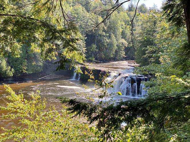
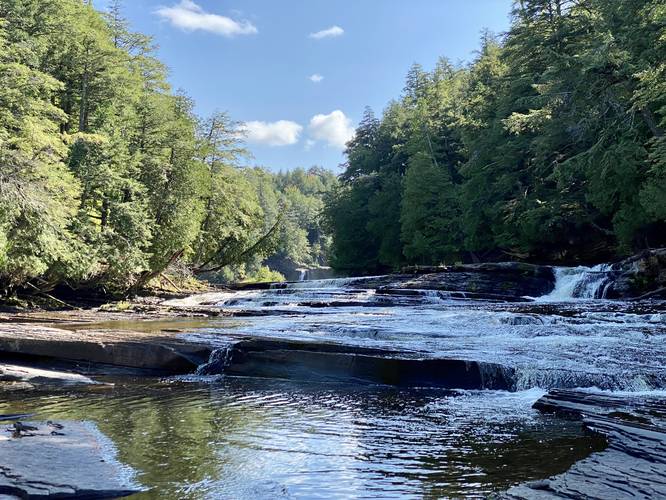
Manabezho Falls - Mile 0.25
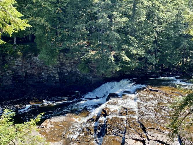
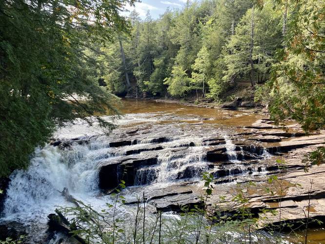
The first waterfall hikers will hit is Manabezho Falls, which cascades down the Presque Isle River at about 30-feet tall and several-dozen feet wide. This overlook provides the best view of this waterfall from the west side of the river. After hiking for a short distance, you'll end up walking down a series of stairs to reach another boardwalk that passes the top of this waterfall, which is a nice sight as well, but the overlook has a better vantage point.
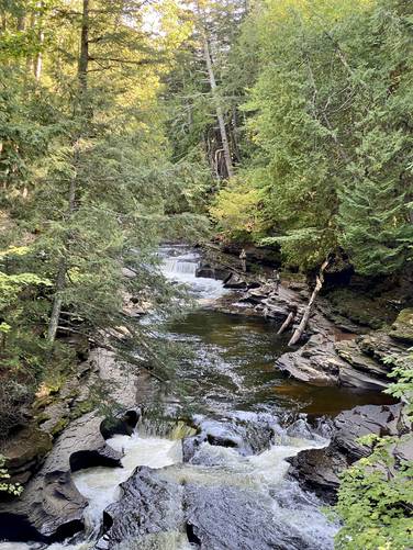
Manido Falls - Mile 0.5
The second waterfall on the list, heading south along the Presque Isle River, is Manido Falls which cascades down at about 15-feet tall and several dozen feet wide. This waterfall is nice, but less impressive than the free-falling drop of Manabezho Falls just downstream. There's a nice viewing platform for the waterfall located here.
Trail Closure - Backtrack 2022
During September 2022, there was a trail closure near the end of the boardwalk trail that used to lead uphill back to the West River Trail / North Country Trail. This trail closure sends hikers back to where they came - either on a looped dirt path or by way of the boardwalk.
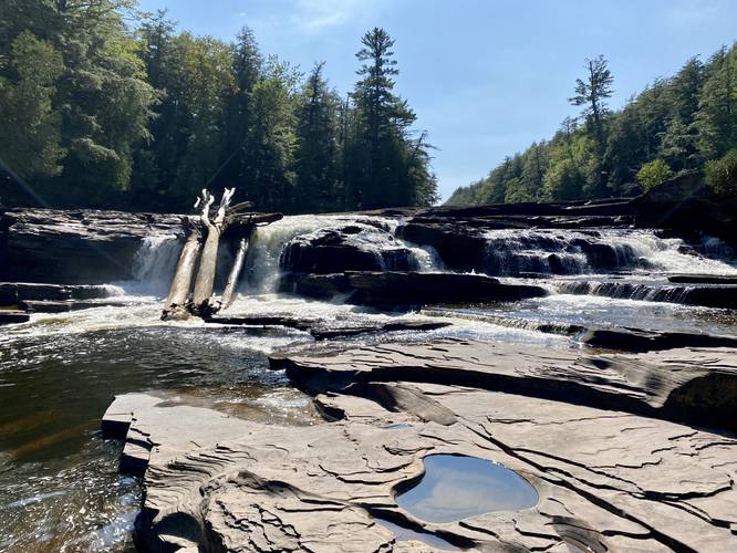
Nawadaha Falls - Mile 1.21
The third waterfall on the list is Nawadaha Falls which sits at about mile 1.21 from the parking lot along this route and cascades down the Presque Isle River at about 20-feet tall and again, several dozen feet wide.
Nawadaha Falls to South Boundary Rd - Mile 1.22 to Mile 1.5
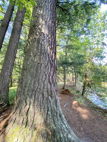
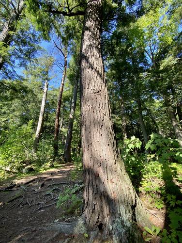
Between miles 1.22 and 1.5, hikers will follow the West River Trail / North Country Trail through an old-growth eastern hemlock forest before reaching South Boundary Rd around mile 1.5. Here, take a left-hand turn to find the trailhead for the East River Trail.
Once on the East River Trail, the hike becomes a bit more difficult as there are no boardwalks or stairs, but rather root steps and some slippery muddy spots along the way. The East River Trail gives views of each of the waterfalls, but hikers must use caution when viewing them as it could be extremely dangerous to walk on crumbling overhangs just for a photo.
Nawadaha Falls - Mile 1.9
At mile 1.9, hikers will pass Nawadaha Falls once more with even better views of the waterfall if during the late Summer as the water tends to flow toward the eastern banks of the river.
Manido Falls - Mile 2.3
At mile 2.3, hikers will pass Manido Falls again. Similar to Nawadaha Falls, the eastern side of the waterfall flows heavier during later seasons in the year.
Manabezho Falls - Mile 2.33
Just after passing Manido Falls, hikers will pass the top of Manabezho Falls around mile 2.33. Note that the best views of Manabezho Falls are generally on the western side of the Presque Isle River.
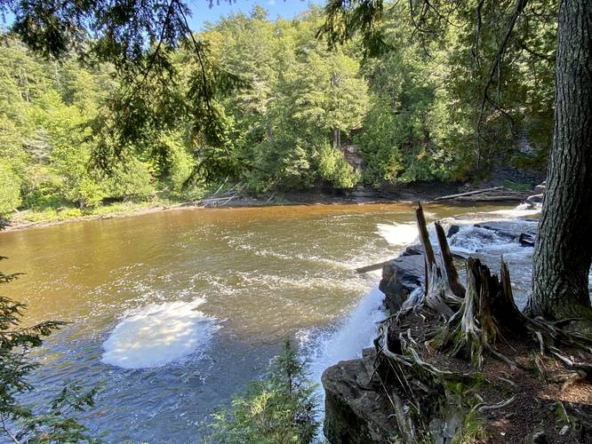
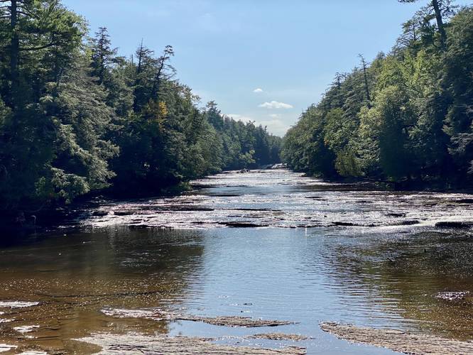
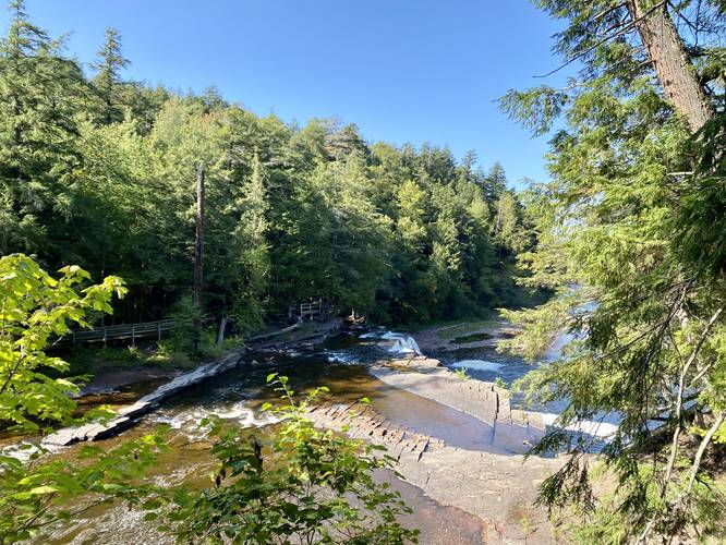
Creek Crossing - Mile 2.65
At mile 2.65 is a creek crossing for the East River Trail that follows the bedrock of the Presque Isle River. During seasons of heavy rain, this section of the river is likely overflowing and too dangerous to attempt a creek crossing. Note that it's best to assess this area before committing to the entire loop. If it's dry enough and if there are no storms present upstream with heavy rains, hikers can walk out onto the bedrock to enjoy more smaller cascades within the Presque Isle River. Just downstream is a popular series of waterfalls that fisherman tend to frequent.
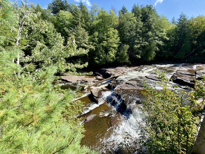
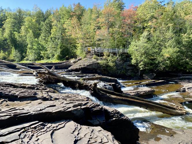
Bridge Crossing, Waterfall Views - Mile 2.8
At mile 2.8, hikers will be in the middle of a footbridge that crosses the river - here is the last scenic stop along this hike with views of several cascades of small waterfalls. If you can't hike the entire loop, this is a main spot to enjoy the river. After crossing the bridge, follow the stairs back up the gorge's hill and back to parking.
Highly-Trafficked
This scenic overlook is one of the most popular trails in the area, so expect a crowd unless you show up when the park opens. During peak foliage, the park can be overloaded with visitors (hence the large parking lot), so plan accordingly.
Parking & Fees
Visitors will find a very large parking lot at the coordinates provided that can fit several dozen vehicles. As of September 2022, there's a $10 entrance fee.
Pets
Dogs are allowed if leashed and their waste must be carried out by the hiker.
Warnings
Ledges: The West River Trail leads along very steep cliffs, but provides a boardwalk with a safety fence the entire way. The East River Trail has many spots where the terrain overhangs the river which could giveway at any time. It's best to keep back from the cliffs.
Flash flooding: It's best to stay out of the Presque Isle River and especially don't swim or wade in the water. Heavy rains upstream could cause flash flooding. Swimmers could also loose their energy or get hurt, where the river would then send them downstream to several large waterfalls, causing major injuries.
Trails
This hike follows several named trails that make up the loop in a counter-clockwise order: West River Trail / North Country Trail, East River Trail. Hikers will also have to walk along South Boundary Road to connect the West River Trail to the East River Trail to complete the loop. Please note that during high water, usually early Spring, the northern-most section of the East River Trail crosses Presque Isle River may flood the trail, since the trail technically crosses the river's bedrock in this area. During late Summer, this section is completely dry.
Hike Description
This hike begins at the northern-most parking lot for the waterfall loop and follows a flat path that leads north toward a series of stairs. Once at the stairs, the loop begins just at the bottom. This recording takes a right-hand turn to experienced the waterfalls from the western side of Presque Isle River before venturing down its eastern banks by following the West River Trail / North Country Trail. The trail will follow plenty of boardwalk areas throughout the western side of the river, making it slightly more accessible to hikers than the rocky and root-filled East River Trail.
Manabezho Falls - Mile 0.25
The first waterfall hikers will hit is Manabezho Falls, which cascades down the Presque Isle River at about 30-feet tall and several-dozen feet wide. This overlook provides the best view of this waterfall from the west side of the river. After hiking for a short distance, you'll end up walking down a series of stairs to reach another boardwalk that passes the top of this waterfall, which is a nice sight as well, but the overlook has a better vantage point.
Manido Falls - Mile 0.5
The second waterfall on the list, heading south along the Presque Isle River, is Manido Falls which cascades down at about 15-feet tall and several dozen feet wide. This waterfall is nice, but less impressive than the free-falling drop of Manabezho Falls just downstream. There's a nice viewing platform for the waterfall located here.
Trail Closure - Backtrack 2022
During September 2022, there was a trail closure near the end of the boardwalk trail that used to lead uphill back to the West River Trail / North Country Trail. This trail closure sends hikers back to where they came - either on a looped dirt path or by way of the boardwalk.
Nawadaha Falls - Mile 1.21
The third waterfall on the list is Nawadaha Falls which sits at about mile 1.21 from the parking lot along this route and cascades down the Presque Isle River at about 20-feet tall and again, several dozen feet wide.
Nawadaha Falls to South Boundary Rd - Mile 1.22 to Mile 1.5
Between miles 1.22 and 1.5, hikers will follow the West River Trail / North Country Trail through an old-growth eastern hemlock forest before reaching South Boundary Rd around mile 1.5. Here, take a left-hand turn to find the trailhead for the East River Trail.
Once on the East River Trail, the hike becomes a bit more difficult as there are no boardwalks or stairs, but rather root steps and some slippery muddy spots along the way. The East River Trail gives views of each of the waterfalls, but hikers must use caution when viewing them as it could be extremely dangerous to walk on crumbling overhangs just for a photo.
Nawadaha Falls - Mile 1.9
At mile 1.9, hikers will pass Nawadaha Falls once more with even better views of the waterfall if during the late Summer as the water tends to flow toward the eastern banks of the river.
Manido Falls - Mile 2.3
At mile 2.3, hikers will pass Manido Falls again. Similar to Nawadaha Falls, the eastern side of the waterfall flows heavier during later seasons in the year.
Manabezho Falls - Mile 2.33
Just after passing Manido Falls, hikers will pass the top of Manabezho Falls around mile 2.33. Note that the best views of Manabezho Falls are generally on the western side of the Presque Isle River.
Creek Crossing - Mile 2.65
At mile 2.65 is a creek crossing for the East River Trail that follows the bedrock of the Presque Isle River. During seasons of heavy rain, this section of the river is likely overflowing and too dangerous to attempt a creek crossing. Note that it's best to assess this area before committing to the entire loop. If it's dry enough and if there are no storms present upstream with heavy rains, hikers can walk out onto the bedrock to enjoy more smaller cascades within the Presque Isle River. Just downstream is a popular series of waterfalls that fisherman tend to frequent.
Bridge Crossing, Waterfall Views - Mile 2.8
At mile 2.8, hikers will be in the middle of a footbridge that crosses the river - here is the last scenic stop along this hike with views of several cascades of small waterfalls. If you can't hike the entire loop, this is a main spot to enjoy the river. After crossing the bridge, follow the stairs back up the gorge's hill and back to parking.
Highly-Trafficked
This scenic overlook is one of the most popular trails in the area, so expect a crowd unless you show up when the park opens. During peak foliage, the park can be overloaded with visitors (hence the large parking lot), so plan accordingly.
Parking & Fees
Visitors will find a very large parking lot at the coordinates provided that can fit several dozen vehicles. As of September 2022, there's a $10 entrance fee.
Pets
Dogs are allowed if leashed and their waste must be carried out by the hiker.
Warnings
Ledges: The West River Trail leads along very steep cliffs, but provides a boardwalk with a safety fence the entire way. The East River Trail has many spots where the terrain overhangs the river which could giveway at any time. It's best to keep back from the cliffs.
Flash flooding: It's best to stay out of the Presque Isle River and especially don't swim or wade in the water. Heavy rains upstream could cause flash flooding. Swimmers could also loose their energy or get hurt, where the river would then send them downstream to several large waterfalls, causing major injuries.