Porcupine Rock Lookout via Don Watson Trail at State Game Lands 75 near Carsontown, Pennsylvania is a difficult 7.5-mile out-and-back hike that leads to the secluded table-top rock vista, Porcupine Rock.
Trails
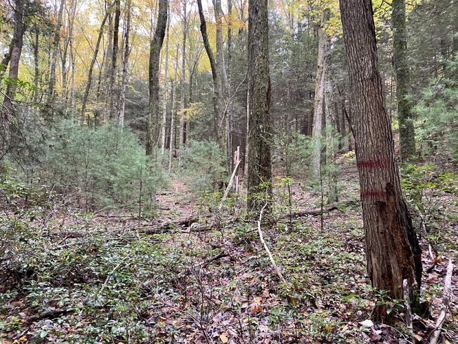
This hike follows one named trail: Don Watson Trail (red blazes).
Bushwhacking
Note that while this hike follows a red blazed trail named the Don Watson Trail, this trail has not been maintained in a very long time (as of October, 2023). Some sections of the trail require short bushwhacks through mountain laurel or forest walking around large sections of blowdowns.
Hike Description
This hike begins along Cemetery Road just north of the hamlet of English Center, at the parking coordinates provided. The hike leads up the red blazed Don Watson Trail as it ascends the mountain along a steep trail. The mountain hollow is by far the hardest section of the hike as the trail runs in and out of loose rocks, loose soil, and dips in and out of a seasonal run (creek). During Autumn, the seasonal creek was dry, which helps traversing the path but during the Spring, after snow melt, the run will likely be a full-on creek which would require a lot more attention to detail to ascend. Note that this ascent starts off moderate but becomes harder and harder as the hiker makes their way near the top - especially so, within the last 250-feet.
Following the Don Watson Trail - Mile 0.65 to 2.75
Once at the top of the mountain, hikers will begin to follow the "easy" section of the Don Watson Trail which follows the top of the mountain for several miles. Along the way, it's imperative that hikers pay attention to the loosely-defined and hard-to-follow red blazes. Along this section of the trail, as of October 2023, hikers will have to bushwhack through short sections of overgrown mountain laurel or around large sections of blowdowns.
Keep Left - Mile 0.78
Around mile 0.78, hikers will find two red lines on a tree - this means "left turn" instead of the standard stacked blazes. This junction is a bit confusing so watch out.
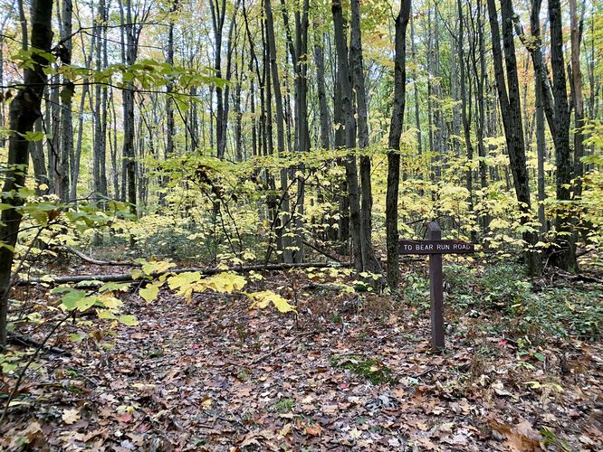
Keep Left - Mile 2.32
Around mile 2.32, hikers will find a slight left turn in the trail with signage for Bear Run Road - take this turn and hike past th sign.
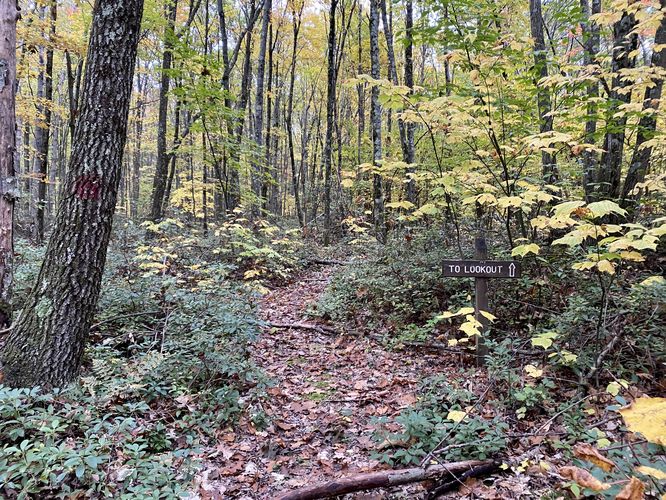
"To Lookout" - Mile 2.6
Around mile 2.6, hikers will find a sign that states "To Lookout" - you're on the right trail, keep hiking.
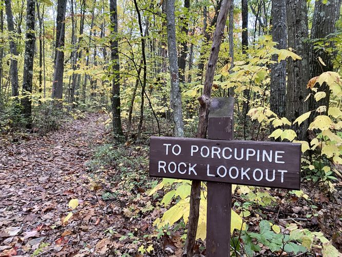
Left-Hand Turn - Mile 2.75
Around mile 2.75, hikers will reach a fork junction in the trail. Here, hikers will want to keep to the left. After taking the left-hand turn there will be signage that states "To Porcupine Rock Lookout".
Reaching Porcupine Rock Lookout - Mile 2.75 to 3.73
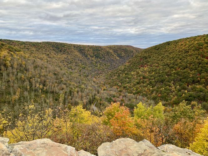
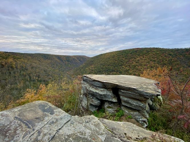
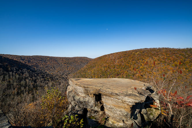
After passing the "To Porcupine Rock Lookout" sign, hikers will be on the last ~1-mile one-way stretch to reach the lookout. The path is relatively flat but slowly makes its way down the mountain spine as it leads northward. Eventually, around mile 3.65, hikers will reach a short bushwhack where the trail passes through mountain laurel. The path will open up once more, just a bit, right before the hiker reaches Porcupine Rock Lookout. Once at the lookout, located around mile 3.73, hikers will find two massive table-top-like rocks with a beautiful view of the uninhabited surrounding mountains. Porcupine Rock is split into two larger rocks, where a hunter or hiker have left a small ladder to help descend the first; however, it's a slight challenge to ascend and descend the 2nd and larger rock to get the best view. Note that Porcupine Rock is named after the constant Porcupine habitation of the rock itself - watch out for any live porcupines as they might shoot quills if spooked. My dog, on this hike, tried to burrow into one of the porcupine's dens which could've ended badly, so keep an eye on your dogs if you bring them here.
Hiking Out - Mile 3.73 to 7.5
The hike out obviously follows the same but opposite path on the way in. Note that the Don Watson Trail signage claims this is a 5-mile loop; however, it was unclear where the loop continued after reaching Porcupine Rock Lookout. On this hike, we technically bushwhacked down the side of the mountain along a super-steep shale-laden mountainside where I lost my phone (thankfully retrieved it the next day), but I would never recommend that route to anyone as it was a huge pain descending the mountain never mind bushwhacking down to Bear Run Road and back to parking. So, with that said, the out-and-back is a much easier way to hike this - that is, unless you find the proper loop for the Don Watson.
Parking
Hikers will find parking at the coordinates provided, located along Cemetery Road just outside of the hamlet of English Center.
Pets
Dogs are allowed if leashed and must be cleaned up after.
Camping & Backpacking
State Game Lands does not allow camping or backpacking. This is a day-hike only.
Warnings
Hunting: Note that State Game Lands are primarily meant for hunting, so it's smart to wear blaze orange when hiking here.
Timber Rattlesnakes: This area is home to the Timber Rattlesnake which can be found roaming the forest floors between late April and early October each year. Be on the lookout and if found, give them plenty of space.
Lack of cell service: This hike does not have much cell coverage (Verizon) outside of the first ascent and early mountain top traverse. Further east, cell service drops out especially when you drop below the mountain top.
Trails
This hike follows one named trail: Don Watson Trail (red blazes).
Bushwhacking
Note that while this hike follows a red blazed trail named the Don Watson Trail, this trail has not been maintained in a very long time (as of October, 2023). Some sections of the trail require short bushwhacks through mountain laurel or forest walking around large sections of blowdowns.
Hike Description
This hike begins along Cemetery Road just north of the hamlet of English Center, at the parking coordinates provided. The hike leads up the red blazed Don Watson Trail as it ascends the mountain along a steep trail. The mountain hollow is by far the hardest section of the hike as the trail runs in and out of loose rocks, loose soil, and dips in and out of a seasonal run (creek). During Autumn, the seasonal creek was dry, which helps traversing the path but during the Spring, after snow melt, the run will likely be a full-on creek which would require a lot more attention to detail to ascend. Note that this ascent starts off moderate but becomes harder and harder as the hiker makes their way near the top - especially so, within the last 250-feet.
Following the Don Watson Trail - Mile 0.65 to 2.75
Once at the top of the mountain, hikers will begin to follow the "easy" section of the Don Watson Trail which follows the top of the mountain for several miles. Along the way, it's imperative that hikers pay attention to the loosely-defined and hard-to-follow red blazes. Along this section of the trail, as of October 2023, hikers will have to bushwhack through short sections of overgrown mountain laurel or around large sections of blowdowns.
Keep Left - Mile 0.78
Around mile 0.78, hikers will find two red lines on a tree - this means "left turn" instead of the standard stacked blazes. This junction is a bit confusing so watch out.
Keep Left - Mile 2.32
Around mile 2.32, hikers will find a slight left turn in the trail with signage for Bear Run Road - take this turn and hike past th sign.
"To Lookout" - Mile 2.6
Around mile 2.6, hikers will find a sign that states "To Lookout" - you're on the right trail, keep hiking.
Left-Hand Turn - Mile 2.75
Around mile 2.75, hikers will reach a fork junction in the trail. Here, hikers will want to keep to the left. After taking the left-hand turn there will be signage that states "To Porcupine Rock Lookout".
Reaching Porcupine Rock Lookout - Mile 2.75 to 3.73
After passing the "To Porcupine Rock Lookout" sign, hikers will be on the last ~1-mile one-way stretch to reach the lookout. The path is relatively flat but slowly makes its way down the mountain spine as it leads northward. Eventually, around mile 3.65, hikers will reach a short bushwhack where the trail passes through mountain laurel. The path will open up once more, just a bit, right before the hiker reaches Porcupine Rock Lookout. Once at the lookout, located around mile 3.73, hikers will find two massive table-top-like rocks with a beautiful view of the uninhabited surrounding mountains. Porcupine Rock is split into two larger rocks, where a hunter or hiker have left a small ladder to help descend the first; however, it's a slight challenge to ascend and descend the 2nd and larger rock to get the best view. Note that Porcupine Rock is named after the constant Porcupine habitation of the rock itself - watch out for any live porcupines as they might shoot quills if spooked. My dog, on this hike, tried to burrow into one of the porcupine's dens which could've ended badly, so keep an eye on your dogs if you bring them here.
Hiking Out - Mile 3.73 to 7.5
The hike out obviously follows the same but opposite path on the way in. Note that the Don Watson Trail signage claims this is a 5-mile loop; however, it was unclear where the loop continued after reaching Porcupine Rock Lookout. On this hike, we technically bushwhacked down the side of the mountain along a super-steep shale-laden mountainside where I lost my phone (thankfully retrieved it the next day), but I would never recommend that route to anyone as it was a huge pain descending the mountain never mind bushwhacking down to Bear Run Road and back to parking. So, with that said, the out-and-back is a much easier way to hike this - that is, unless you find the proper loop for the Don Watson.
Parking
Hikers will find parking at the coordinates provided, located along Cemetery Road just outside of the hamlet of English Center.
Pets
Dogs are allowed if leashed and must be cleaned up after.
Camping & Backpacking
State Game Lands does not allow camping or backpacking. This is a day-hike only.
Warnings
Hunting: Note that State Game Lands are primarily meant for hunting, so it's smart to wear blaze orange when hiking here.
Timber Rattlesnakes: This area is home to the Timber Rattlesnake which can be found roaming the forest floors between late April and early October each year. Be on the lookout and if found, give them plenty of space.
Lack of cell service: This hike does not have much cell coverage (Verizon) outside of the first ascent and early mountain top traverse. Further east, cell service drops out especially when you drop below the mountain top.