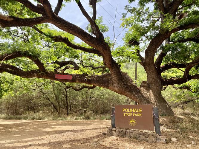
Polihale Beach & Na Pali Cliffs at Polihale State Park near Waimea, Hawaii (Kauai) is a moderate 0.5-mile out-and-back walk that leads to the stunning view of Kauai's southern-most remote cliffs along the Na Pali coast; however, this location requires experience driving on extremely-rutted and pothole-filled dirt roads, a 4-wheel-drive vehicle or a vehicle with high-clearance, and includes sections of road that have deep sand that could ultimately get a visitor completely stranded.
Getting to Polihale State Park
Before describing this short walk, visitors must be fully prepared before considering an adventure to Polihale State Park, especially in low-clearance rental vehicles. Most online reviews mention the road to reach Polihale State Park is ~3.5-mile one-way, full of potholes, and ruts - some can be extremely deep. These potholes start at the junction of Kiko Rd and Lower Saki Mana Rd / Polihale Rd near Waimea, HI (Kauai) and they do not end until 4.8-miles down the road - which is where the turn to "Camping Area 4" is located and is over 1-mile from the first entrance to Polihale State Park. Often, drivers will have to drive on the opposite side of the road or in random patterns to avoid massive potholes. Additionally, at "Camping Area 4" is where the road heads downhill along a sandy path. This is where you should be concerned if not in a 4-wheel-drive high-clearance vehicle, since most 2-wheel-drive rental cars can get stuck down there. We made the mistake of bringing our 2-wheel-drive rental car down this section, which was fine until we reached the first junction which appeared to have deep sand in both directions. Like an idiot, I attempted the deep sand, but could not climb with the car up to a parking area, so I backed up and got stuck in deep sand adjacent to the sandy road (with compacted sand). We placed towels by the wheels for grip, and dug the wheels out slightly, allowing us to move the car out from the deep sand and back onto the compacted sand. Lesson learned - hopefully this write-up helps someone else in the future by avoiding the turn down from "Campsite Area 4". The rutted and pothole-filled road is another story - this road has a max speed of ~11MPH in very few short sections and an average speed of ~5MPH, so the travel time is close to 45-minutes from the junction to reach Polihale Beach. Only experienced dirt-road backcountry or off-road drivers should attempt this road, especially in low-clearance 2-wheel-drive vehicles. Drive at your own risk.
Hike Description
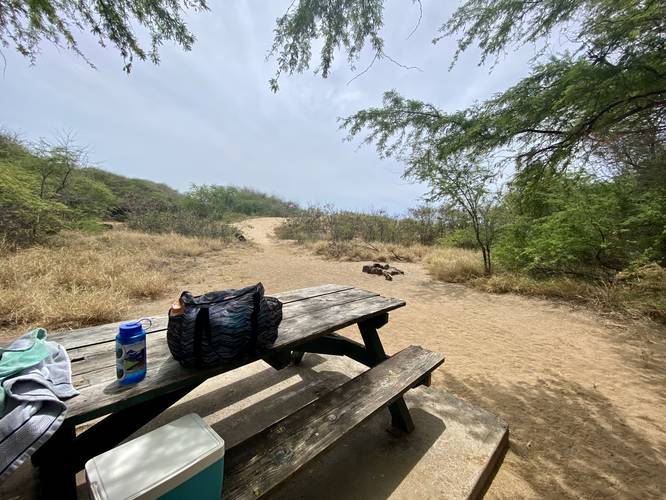
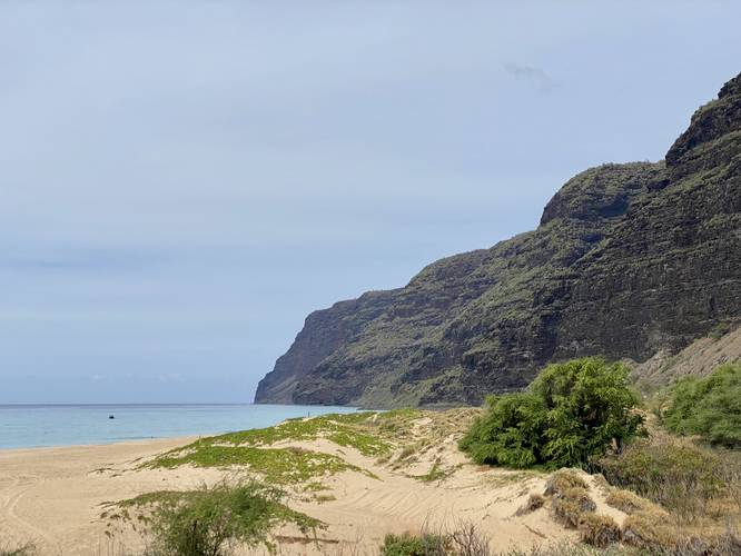
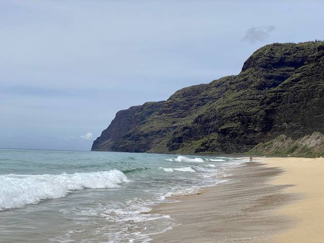
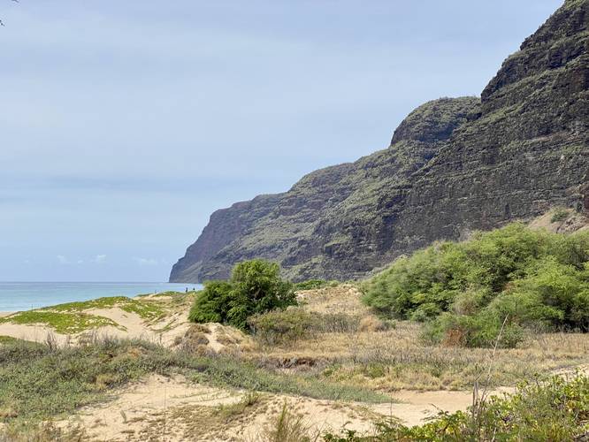
Polihale Beach has plenty of access points, but as described above in the "Getting to Polihale State Park" section, we attempted to reach the very-end of the road to view the southern coastal cliffs of the Na Pali coast. After getting our car unstuck from the deep sand, we parked right off of the compacted sand road near the end of Polihale Rd and walked in from there. We found a nice campsite located at the top of the sand dunes, surrounded by trees, providing shade, and included a picnic table. This campsite has a couple of nice views of the Na Pali coastal cliffs, located at the end of Polihale State Park. After cooling down, we walked down the trail and out to the beach where we found a decent-amount of 4-wheel-driving campers setup with tents and fishing poles. Most day-visitors had tents setup since there's virtually no shade on the beach itself - without hiking up the dunes to find shade amongst the trees. From here, we hiked back to the campsite and then left. It was a great experience seeing the Na Pali coastal cliffs from a different perspective, but the anxiety from getting stuck, in addition to at least 1.5-hours of anxiety-ridden driving might not be worth the efforts to everyone. Nonetheless, we had a nice adventure at Polihale State Park.
Parking
As stated above, 4-wheel-drive vehicles are almost a necessity to get to Polihale State Park. You can make a 2-wheel-drive work, but only if you have experience driving in these types of extremely-rutted and pothole-filled roads and if the vehicle has enough clearance. There are several parking locations at Polihale State Park; however, the parking coordinates here bring you to almost the very-end of the road, located on a compacted sand road which eventually turns into deep sand. Note that most rental car businesses on the island do not want you driving here and may void any purchased warranties. Towing fees are likely hundreds of dollars per tow and cell service is a bit limited in this area. Drive at your own risk.
Pets
Dogs are not allowed.
Camping and Overnight Use
As of June, 2022 Polihale State Park does not allow camping or overnight use despite existing campsites onsite. Please respect all of the state park rules.
Respecting the Land
Hawaiian land is considered sacred to native Hawaiians and many locals, so please stay on-trail, take nothing but photos, and leave nothing but footprints. Respect the locals - don't stay for long and have a backup hike planned in case the parking lot is full.
Getting to Polihale State Park
Before describing this short walk, visitors must be fully prepared before considering an adventure to Polihale State Park, especially in low-clearance rental vehicles. Most online reviews mention the road to reach Polihale State Park is ~3.5-mile one-way, full of potholes, and ruts - some can be extremely deep. These potholes start at the junction of Kiko Rd and Lower Saki Mana Rd / Polihale Rd near Waimea, HI (Kauai) and they do not end until 4.8-miles down the road - which is where the turn to "Camping Area 4" is located and is over 1-mile from the first entrance to Polihale State Park. Often, drivers will have to drive on the opposite side of the road or in random patterns to avoid massive potholes. Additionally, at "Camping Area 4" is where the road heads downhill along a sandy path. This is where you should be concerned if not in a 4-wheel-drive high-clearance vehicle, since most 2-wheel-drive rental cars can get stuck down there. We made the mistake of bringing our 2-wheel-drive rental car down this section, which was fine until we reached the first junction which appeared to have deep sand in both directions. Like an idiot, I attempted the deep sand, but could not climb with the car up to a parking area, so I backed up and got stuck in deep sand adjacent to the sandy road (with compacted sand). We placed towels by the wheels for grip, and dug the wheels out slightly, allowing us to move the car out from the deep sand and back onto the compacted sand. Lesson learned - hopefully this write-up helps someone else in the future by avoiding the turn down from "Campsite Area 4". The rutted and pothole-filled road is another story - this road has a max speed of ~11MPH in very few short sections and an average speed of ~5MPH, so the travel time is close to 45-minutes from the junction to reach Polihale Beach. Only experienced dirt-road backcountry or off-road drivers should attempt this road, especially in low-clearance 2-wheel-drive vehicles. Drive at your own risk.
Hike Description
Polihale Beach has plenty of access points, but as described above in the "Getting to Polihale State Park" section, we attempted to reach the very-end of the road to view the southern coastal cliffs of the Na Pali coast. After getting our car unstuck from the deep sand, we parked right off of the compacted sand road near the end of Polihale Rd and walked in from there. We found a nice campsite located at the top of the sand dunes, surrounded by trees, providing shade, and included a picnic table. This campsite has a couple of nice views of the Na Pali coastal cliffs, located at the end of Polihale State Park. After cooling down, we walked down the trail and out to the beach where we found a decent-amount of 4-wheel-driving campers setup with tents and fishing poles. Most day-visitors had tents setup since there's virtually no shade on the beach itself - without hiking up the dunes to find shade amongst the trees. From here, we hiked back to the campsite and then left. It was a great experience seeing the Na Pali coastal cliffs from a different perspective, but the anxiety from getting stuck, in addition to at least 1.5-hours of anxiety-ridden driving might not be worth the efforts to everyone. Nonetheless, we had a nice adventure at Polihale State Park.
Parking
As stated above, 4-wheel-drive vehicles are almost a necessity to get to Polihale State Park. You can make a 2-wheel-drive work, but only if you have experience driving in these types of extremely-rutted and pothole-filled roads and if the vehicle has enough clearance. There are several parking locations at Polihale State Park; however, the parking coordinates here bring you to almost the very-end of the road, located on a compacted sand road which eventually turns into deep sand. Note that most rental car businesses on the island do not want you driving here and may void any purchased warranties. Towing fees are likely hundreds of dollars per tow and cell service is a bit limited in this area. Drive at your own risk.
Pets
Dogs are not allowed.
Camping and Overnight Use
As of June, 2022 Polihale State Park does not allow camping or overnight use despite existing campsites onsite. Please respect all of the state park rules.
Respecting the Land
Hawaiian land is considered sacred to native Hawaiians and many locals, so please stay on-trail, take nothing but photos, and leave nothing but footprints. Respect the locals - don't stay for long and have a backup hike planned in case the parking lot is full.