The Pixley Falls Trail at Pixley Falls State Park in Boonville, New York is an easy 0.4-mile out-and-back hike that leads to the 50-foot waterfall, Pixley Falls in addition to several other waterfalls.
Hike Description
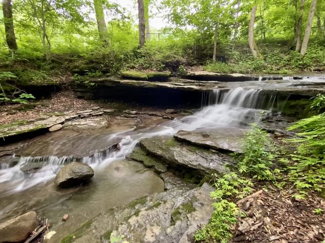
This hike begins at the southern end of the main pavilion at Pixley Falls State Park and follows an unmarked trail into the woods, located at the southeast corner of the road. Hikers will pass a fence and then a very large boulder (likely a glacial deposit) before the trail crosses a tributary creek. On the other side of this creek crossing is a nice 3-foot tall waterfall, Upper Shelf Falls.
The trail will then lead to another parking lot, then turn to head downhill. Hikers will find another tributary creek located on their left-hand side as the trail gets closer to the bottom of the hill, take a left-hand turn here to reach another waterfall.
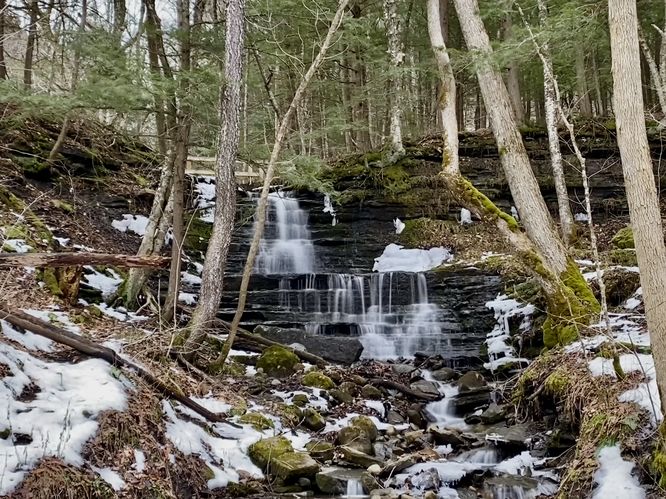
Step Falls (10-feet tall) - Mile 0.1
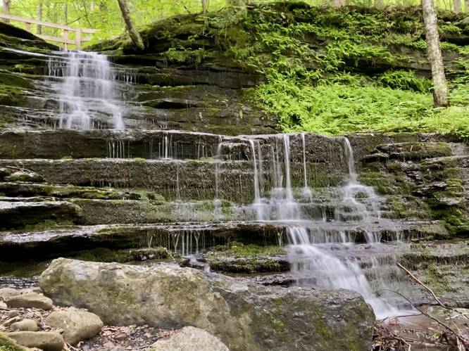
Around mile 0.1, if you take a left-hand turn near the bottom of the hill, hikers will find Step Falls cascading over two tiers of bedrock and sits at about 10-feet tall. There's a wooden bridge above the waterfall which gives it a unique feel along with ferns growing along the outer banks of the creek.
Pixley Falls Lookout - Mile 0.13
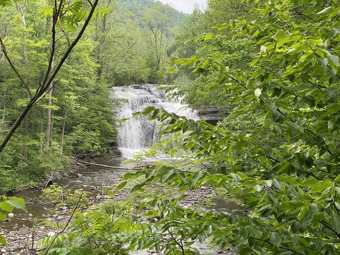
After exploring Step Falls, hikers will find a view of Pixley Falls from the main trail around mile 0.13.
Pixley Falls (50-feet tall) - Mile 0.17 to 0.2
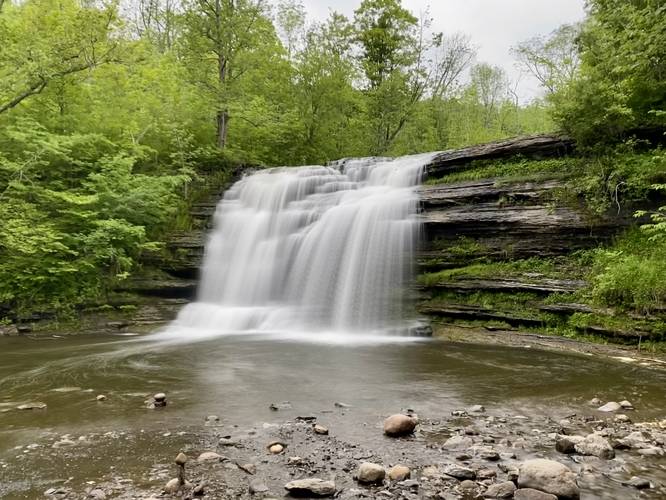
Around mile 0.17, hikers will reach the main viewing area for Pixley Falls. If the water level is low enough, hikers can cross the creek to reach a better view closer to the base of the roaring waterfall. Pixley Falls cascades down the Lansing Kill river at about 50-feet tall.
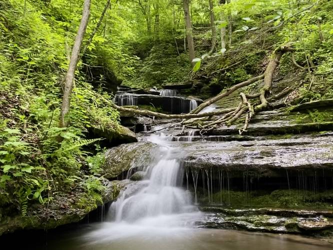
Shelf Falls (mutli-tiered waterfall) - Mile 0.2
If you choose, hikers can walk up the tributary creek that feeds into Lansing Kill adjacent to Pixley Falls to view Shelf Falls upclose. Shelf Falls is a multi-tiered waterfall that cascades down the creek's bedrock in a multitude of cascades - most of which are about 2-feet tall.
After visiting all of the waterfalls, the hike out is a quick uphill jaunt back to parking.
Parking
Hikers will find parking at the coordinates provided. The turnout and parking lots at the state park are large enough to fit several dozen vehicles.
Pets
Dogs are allowed only if leashed and must be cleaned up after.
Hike Description
This hike begins at the southern end of the main pavilion at Pixley Falls State Park and follows an unmarked trail into the woods, located at the southeast corner of the road. Hikers will pass a fence and then a very large boulder (likely a glacial deposit) before the trail crosses a tributary creek. On the other side of this creek crossing is a nice 3-foot tall waterfall, Upper Shelf Falls.
The trail will then lead to another parking lot, then turn to head downhill. Hikers will find another tributary creek located on their left-hand side as the trail gets closer to the bottom of the hill, take a left-hand turn here to reach another waterfall.
Step Falls (10-feet tall) - Mile 0.1
Around mile 0.1, if you take a left-hand turn near the bottom of the hill, hikers will find Step Falls cascading over two tiers of bedrock and sits at about 10-feet tall. There's a wooden bridge above the waterfall which gives it a unique feel along with ferns growing along the outer banks of the creek.
Pixley Falls Lookout - Mile 0.13
After exploring Step Falls, hikers will find a view of Pixley Falls from the main trail around mile 0.13.
Pixley Falls (50-feet tall) - Mile 0.17 to 0.2
Around mile 0.17, hikers will reach the main viewing area for Pixley Falls. If the water level is low enough, hikers can cross the creek to reach a better view closer to the base of the roaring waterfall. Pixley Falls cascades down the Lansing Kill river at about 50-feet tall.
Shelf Falls (mutli-tiered waterfall) - Mile 0.2
If you choose, hikers can walk up the tributary creek that feeds into Lansing Kill adjacent to Pixley Falls to view Shelf Falls upclose. Shelf Falls is a multi-tiered waterfall that cascades down the creek's bedrock in a multitude of cascades - most of which are about 2-feet tall.
After visiting all of the waterfalls, the hike out is a quick uphill jaunt back to parking.
Parking
Hikers will find parking at the coordinates provided. The turnout and parking lots at the state park are large enough to fit several dozen vehicles.
Pets
Dogs are allowed only if leashed and must be cleaned up after.