Loading...

๐ŸŽ‰ Enjoy a Free 7-Day Supporter Trial and Unlock Exclusive Perks โ€” No Credit Card Required. Learn more.

Pitt Street Bridge Trail

Directions
Map
Pictures
Send to App
Distance:
0.8 Miles / 1.3 km
Type:
Out-and-Back
Difficulty:
Easy
Time to Hike:
~24 minutes
Features:
Surface Type:
Universal Access
Town:
Mount Pleasant, South Carolina
Directions:
32.774184, -79.863057
Added:
March 03, 2024
Updated:
May 03, 2024
Copy Trail Link Hiking this trail? Send a friend or family member a link to this trail guide for your own safety. Hike at your own risk (disclaimer)
Loading...
Loading...
5'

Total Change
6'

Ascent
6'

Descent

Download the Trail Route for Offline Use

Supporters get exclusive access to download trail routes to the MyHikes app for offline use. Stay prepared on your adventure, even without an internet connection! Become a Supporter today to unlock this feature and hike with confidence.

Send to App

Pitt Street Bridge Trail

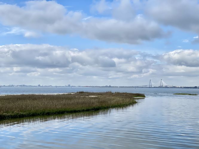
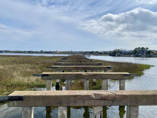
The Pitt Street Bridge Trail in Mount Pleasant, South Carolina is an easy universally accessible out-and-back trail that features views of Charleston and a boardwalk that spans a portion of the old Pitt Street Bridge.

This is not a hike but rather a short out-and-back walk through Pitt Street Bridge Park where visitors will find views of Charleston, Mount Pleasant, and the bay. The path follows a paved surface for most of the way until you reach the old Pitt Street Bridge that was in use from 1864 to 1927. Once at the old bridge, you'll find a boardwalk was constructed over a small section of the bridge's old foundational pillars - the boardwalk provides outlets for fishing and room for folks to take in the scenery. From the end of the boardwalk, you'll find views toward Sullivan's Island where the remnants of the old bridge still stand today.

Parking
Walkers will find parking for the Pitt Street Bridge along Pitt Street near the coordinates provided. The street has parallel parking in dirt turnouts along the west side of the street. Note that this park fills up quickly on nice days, so do not overcrowd or park in the non-parking zones along the residential streets to the north.

Pets
Dogs are allowed only if leashed and must be cleaned up after.
Explore 6 trails near Mount Pleasant, SC
  1. Parking

    32.774184, -79.863057
  2. Main Trailhead

    32.77402, -79.863023
  3. View of Charleston, SC from the Pitt Street Bridge Trail

    32.770181, -79.862214
    View of Charleston, SC from the Pitt Street Bridge Trail
  4. Remnants of the old Pitt Street Bridge

    32.768347, -79.861822
    Remnants of the old Pitt Street Bridge
No community routes found. To add your own hike as a Community Route for this Trail guide, leave a Trip Report with an attached GPX file.

Seasons

All

Trip Reports

Trail Guide By:
Admin user profile picture
0.8 miles / 1.3 km
0.8 miles / 1.3 km
March 03, 2024
Beautiful walk along the water.
Hiking

Weather Forecast

In Mount Pleasant, SC

Explore Hiking Trails

You May Also Like

Colorado's Million Dollar Highway - Plan a day's drive adventure along the iconic Million Dollar Highway in Colorado. Explore the best short trails, roadside stops, waterfalls, vistas, ghost towns, and hot springs within a ~6 hour road trip.
Explore

Colorado's Million Dollar Highway

Plan a day's drive adventure along the iconic Million Dollar Highway in Colorado. Explore the best short trails, roadside stops, waterfalls, vistas, ghost towns, and hot springs within a ~6 hour road trip.

Read
Glacier's Going-to-the-Sun Road - Discover the breathtaking beauty of Glacier National Park along the iconic Going-to-the-Sun Road. From stunning roadside stops to picturesque waterfalls and vistas, this engineering marvel offers endless opportunities for exploration.
Explore

Glacier's Going-to-the-Sun Road

Discover the breathtaking beauty of Glacier National Park along the iconic Going-to-the-Sun Road. From stunning roadside stops to picturesque waterfalls and vistas, this engineering marvel offers endless opportunities for exploration.

Read
New York's Best Waterfalls - Whether you're planning a day hike, roadside stop, or a leisurely short walk, this guide provides hikers, travelers, and locals alike with 63 different locations to over 100 scenic waterfalls to help plan your next adventure!
Explore

New York's Best Waterfalls

Whether you're planning a day hike, roadside stop, or a leisurely short walk, this guide provides hikers, travelers, and locals alike with 63 different locations to over 100 scenic waterfalls to help plan your next adventure!

Read

Before you boogie...

Find our trail guides useful? Consider becoming a Supporter to unlock perks!

MyHikes is an indie platform that makes exploring public trails easier for everyone. The platform has no investors, no ads, and is owned and operated by one person, Dave Miller. Dave has personally mapped and written over 1,800 trail guides on MyHikes for the public to explore. MyHikes has helped millions outdoor enthusiasts plan their next adventure.

But it takes a lot of time ๐Ÿ•ฆ, money ๐Ÿ’ฐ, work, and espresso shots โ˜• to run MyHikes, including hiking , mapping , writing , and publishing new trails with high-quality (accurate) information... along with software engineering (coding) the platform like building new features, website and mobile app development (iOS and Android), site maintainance . and much much more.

Supporters unlock website and mobile app perks with an annual one-time payment of $25 (you renew) ๐Ÿ˜Ž๐Ÿ‘. Or you can simply make a Donation of your choice. Otherwise, you can support us by telling your friends about MyHikes - both quick and free ๐ŸŽ‰

Admin user profile picture

Dave Miller
MyHikes Founder