The Pine Tree, Tunnel, & Landscape Arches hike at Arches National Park near Moab, Utah is an easy 2.3-mile out-and-back hike that features views of three arches within the Devils Garden.
Trails
This hike follows the Devils Garden Trail.
Hike Description
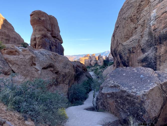
The hike begins at the main trailhead for the Devils Garden Trail and follows a sandy path that it heads northwest into the scrubland-filled cliff outcropping of a desert known as the Devils Garden. The trail first passes through a series of tall cliffs before it leads hikers into an open area where the pathway quickly splits with a right-hand turn.
Turn to Pine Tree & Tunnel Arches - Mile 0.25 to 0.65
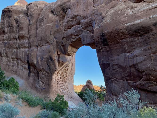
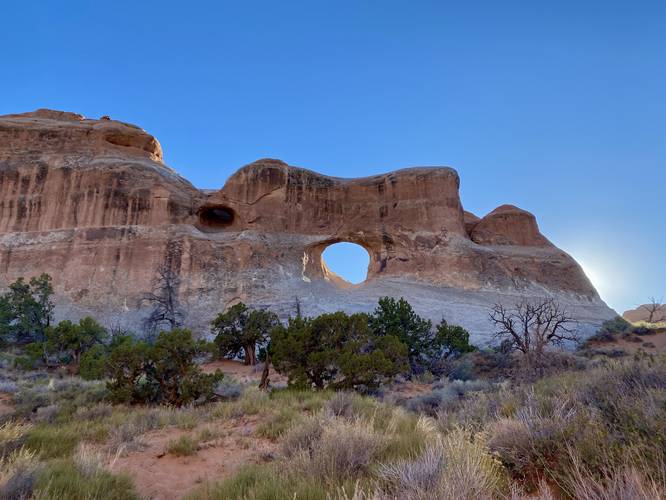
Around mile 0.25, hikers can take a right-hand turn to hike down to the Pine Tree and Tunnel Arches. This track heads to the Pine Tree Arch first, located around mile 0.45. The Pine Tree Arch is named after the single pine tree located directly under the archway. The trail technically ends at the viewpoint for Pine Tree Arch, so hikers can head back to where they previously split for the Pine Tree Arch to hike to the Tunnel Arch. At mile 0.65, hikers will reach the viewpoint for the Tunnel Arch, which sits on the cliff wall located to the south -- hard to miss, really. The Tunnel Arch is named after the short but elongated "tunnel" that passes through the rock to reach the other side of the cliff wall. It also provides a tunnel of sunlight that beacons down on the landscape below -- something some hikers and photographers are apparently into. After visiting both the Pine Tree and Tunnel Arches, hikers will continue along the Devils Garden Trail to hike to the Landscape Arch.
Devils Garden Trail View - Mile 1
Around mile 1, hikers will reach a beautiful view of the Devils Garden and the trail -- turn back toward the trailhead where you hiked in from as you hike to the top of the nearest hill along the trail. This unique view provides hikers with a glimpse of what the Devils Garden has to offer without having to commit to a long hike.
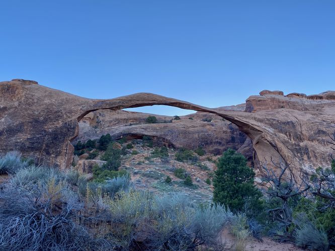
Landscape Arch - Mile 1.4
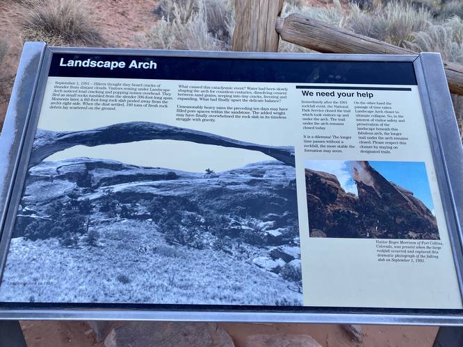
On the hike to the Landscape Arch, the trail will undulate quite a bit -- while these short hills are not very tall, it provides a decent workout. At mile 1.3, hikers will reach a historical and geological information kiosk about the Landscape Arch. Here, the trail also switches from a harder surface and back to sand -- most of which is pretty tough to hike through and slows you down. At mile 1.4, the trail takes another bend to reach the viewpoint for the Landscape Arch. The view of Landscape Arch can only be enjoyed from the trail -- as noted in the information kiosk that in 1991 a massive rockfall caused the park to close that section of the park to visitors.
Wall Arch View - Mile 1.4
While not noted in the main title, this hike also features a view of the Wall Arch. The Wall Arch is located a bit further up the trail, but required a lot more effort to hike to. We didn't have enough time to explore any further, but were able to get a view of the Wall Arch from the same viewpoint for the Landscape Arch.
Hiking Out - Mile 1.4 to 2.3
The hike out is a bit quicker than the hike in as you'll skip the Pine Tree & Tunnel Arch spur trails. Hikers also get to check out the trail view of the Devils Garden, with its greenery and red-hued cliffs, on the short hill descent located around mile 1.8. The short hike ends back at the parking lot at mile 2.3.
How to Get Into Arches National Park
Note that Arches National Park, as of September 2023 (and earlier) only allows vehicles to enter the park during scheduled time slots. You can read all about Arches' timed entry here and you can find reservation information here. Reservations are grabbed quickly, so be sure to log onto the reservation website when the date opens up to grab your timed entry ticket. Note that vehicles can enter the park outside of the timed entry slots (i.e. before 7AM or after 4PM each day, as of September 2023). If you do not have a timed entry ticket between 7AM and 4PM, do not wait in line to enter the park as you will be turned away and will slow everyone else down. The vehicle line to enter the park is very long and wait-times to enter can be a pain so show up prepared.
Parking
Hikers will find a massive parking lot at the coordinates provided at the end of Arches National Park Road / Devils Garden Road in Arches National Park. The lot is large enough to fit many dozens of vehicles. Parking here fills up very quickly -- generally by late morning.
Popularity
This is a very-popular hike at Arches National Park, so you'll likely see plenty of other people on the trail.
Pets
Dogs are not allowed on any trails at Arches National Park. Please do not bring your dog here.
Fees
As of September 2023, there's a $30 fee per vehicle to enter Arches National Park.
Warnings
Sun exposure: This trail has very little shade and no water sources. Pack-in all water and wear sun screen and a hat to protect against sun exposure. It's smart to hike either in the early morning or late afternoon to avoid the intense desert sun.
No water: This trail has no water sources so you must pack-in all water. A general rule of thumb in the desert is 1 gallon of water per person per day.
Rattlesnakes: This is rattlesnake territory, so be on the lookout and give any rattlers you find plenty of space.
Rockfalls: This trail passes cliffs that could have rockfall activity.
Trails
This hike follows the Devils Garden Trail.
Hike Description
The hike begins at the main trailhead for the Devils Garden Trail and follows a sandy path that it heads northwest into the scrubland-filled cliff outcropping of a desert known as the Devils Garden. The trail first passes through a series of tall cliffs before it leads hikers into an open area where the pathway quickly splits with a right-hand turn.
Turn to Pine Tree & Tunnel Arches - Mile 0.25 to 0.65
Around mile 0.25, hikers can take a right-hand turn to hike down to the Pine Tree and Tunnel Arches. This track heads to the Pine Tree Arch first, located around mile 0.45. The Pine Tree Arch is named after the single pine tree located directly under the archway. The trail technically ends at the viewpoint for Pine Tree Arch, so hikers can head back to where they previously split for the Pine Tree Arch to hike to the Tunnel Arch. At mile 0.65, hikers will reach the viewpoint for the Tunnel Arch, which sits on the cliff wall located to the south -- hard to miss, really. The Tunnel Arch is named after the short but elongated "tunnel" that passes through the rock to reach the other side of the cliff wall. It also provides a tunnel of sunlight that beacons down on the landscape below -- something some hikers and photographers are apparently into. After visiting both the Pine Tree and Tunnel Arches, hikers will continue along the Devils Garden Trail to hike to the Landscape Arch.
Devils Garden Trail View - Mile 1
Around mile 1, hikers will reach a beautiful view of the Devils Garden and the trail -- turn back toward the trailhead where you hiked in from as you hike to the top of the nearest hill along the trail. This unique view provides hikers with a glimpse of what the Devils Garden has to offer without having to commit to a long hike.
Landscape Arch - Mile 1.4
On the hike to the Landscape Arch, the trail will undulate quite a bit -- while these short hills are not very tall, it provides a decent workout. At mile 1.3, hikers will reach a historical and geological information kiosk about the Landscape Arch. Here, the trail also switches from a harder surface and back to sand -- most of which is pretty tough to hike through and slows you down. At mile 1.4, the trail takes another bend to reach the viewpoint for the Landscape Arch. The view of Landscape Arch can only be enjoyed from the trail -- as noted in the information kiosk that in 1991 a massive rockfall caused the park to close that section of the park to visitors.
Wall Arch View - Mile 1.4
While not noted in the main title, this hike also features a view of the Wall Arch. The Wall Arch is located a bit further up the trail, but required a lot more effort to hike to. We didn't have enough time to explore any further, but were able to get a view of the Wall Arch from the same viewpoint for the Landscape Arch.
Hiking Out - Mile 1.4 to 2.3
The hike out is a bit quicker than the hike in as you'll skip the Pine Tree & Tunnel Arch spur trails. Hikers also get to check out the trail view of the Devils Garden, with its greenery and red-hued cliffs, on the short hill descent located around mile 1.8. The short hike ends back at the parking lot at mile 2.3.
How to Get Into Arches National Park
Note that Arches National Park, as of September 2023 (and earlier) only allows vehicles to enter the park during scheduled time slots. You can read all about Arches' timed entry here and you can find reservation information here. Reservations are grabbed quickly, so be sure to log onto the reservation website when the date opens up to grab your timed entry ticket. Note that vehicles can enter the park outside of the timed entry slots (i.e. before 7AM or after 4PM each day, as of September 2023). If you do not have a timed entry ticket between 7AM and 4PM, do not wait in line to enter the park as you will be turned away and will slow everyone else down. The vehicle line to enter the park is very long and wait-times to enter can be a pain so show up prepared.
Parking
Hikers will find a massive parking lot at the coordinates provided at the end of Arches National Park Road / Devils Garden Road in Arches National Park. The lot is large enough to fit many dozens of vehicles. Parking here fills up very quickly -- generally by late morning.
Popularity
This is a very-popular hike at Arches National Park, so you'll likely see plenty of other people on the trail.
Pets
Dogs are not allowed on any trails at Arches National Park. Please do not bring your dog here.
Fees
As of September 2023, there's a $30 fee per vehicle to enter Arches National Park.
Warnings
Sun exposure: This trail has very little shade and no water sources. Pack-in all water and wear sun screen and a hat to protect against sun exposure. It's smart to hike either in the early morning or late afternoon to avoid the intense desert sun.
No water: This trail has no water sources so you must pack-in all water. A general rule of thumb in the desert is 1 gallon of water per person per day.
Rattlesnakes: This is rattlesnake territory, so be on the lookout and give any rattlers you find plenty of space.
Rockfalls: This trail passes cliffs that could have rockfall activity.