Pennsylvania State Game Lands 13 is loaded with beautiful waterfalls that rival it's neighbor of Ricketts Glen State Park. This guide focues on the cluster of waterfalls and cascades of Pigeon Run and the stunning Atticus Falls, located on Sullivan Run, for a difficult 2.7-mile out-and-back hike.
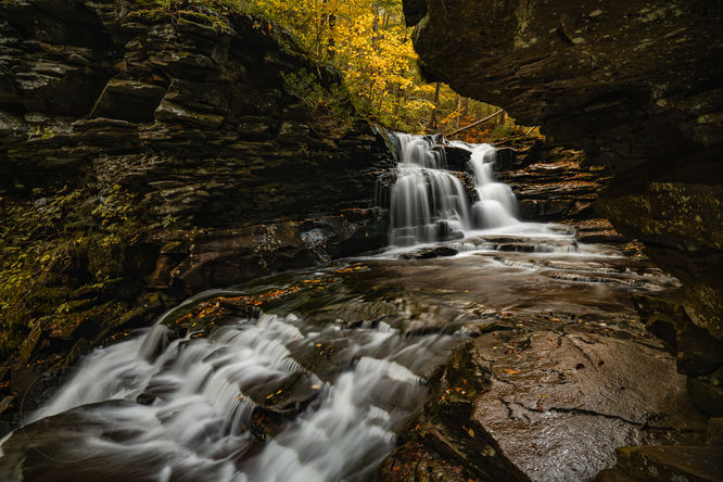
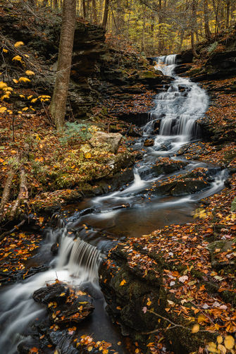
As you continue your hike about .4 of mile, there will be a fork in the paths, stay to the left or the lower route to Pigeon Run which is about another .2 of a mile. Where the route crosses Pigeon Run there are falls and cascades both up and down the run. The largest of the waterfalls is near the bottom just before Pigeon Run dumps into Sullivan Branch.
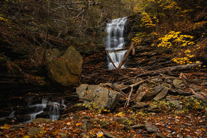
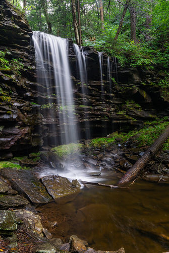
Once you are done exploring Pigeon Run continue on the old grade, it is a short distance to Atticus Falls, at approximately .3 of mile beyond Pigeon Run, you will want to leave the old grade and work your way to Sullivan Branch. Use caution as this waterfall is enclosed by rock ledges on both sides. You can access it from the bottom or the top and is one of the most beautiful spots I have visited. Depending on your comfort level, you can climb in along side of the waterfall within the rocks. It's a truly amazing place.
Once you are done taking photos and exploring, retrace your steps back to the parking area.
Small cliffs: This hike leads to waterfalls that might be surrounded by steep cliffs. Accessing the cascades leads hikers off-trail and may be dangerous depending on your skill and level of comfort. Always use caution when near these cliffs or deep pools of water.
Parking
The parking for this hike is a large pull off along Sullivan Falls Road which is marked with a large rock labeled 'Sullivan Falls' and is the same parking if you were going to visit Sullivan Falls. This forest road is not maintained in the winter and access could be limited based on road conditions.Hike
There is a pathway just up the road from the parking area towards Big Run that you can utilize and follows an old grade most for most of this hike. This is a clearly used route, but it is not an official trail and not marked in any way. Once on this you will almost immediately come to the crossing at Big Run, depending on the flow you may get wet feet, but typically I have been able to cross without issue.As you continue your hike about .4 of mile, there will be a fork in the paths, stay to the left or the lower route to Pigeon Run which is about another .2 of a mile. Where the route crosses Pigeon Run there are falls and cascades both up and down the run. The largest of the waterfalls is near the bottom just before Pigeon Run dumps into Sullivan Branch.
Once you are done exploring Pigeon Run continue on the old grade, it is a short distance to Atticus Falls, at approximately .3 of mile beyond Pigeon Run, you will want to leave the old grade and work your way to Sullivan Branch. Use caution as this waterfall is enclosed by rock ledges on both sides. You can access it from the bottom or the top and is one of the most beautiful spots I have visited. Depending on your comfort level, you can climb in along side of the waterfall within the rocks. It's a truly amazing place.
Once you are done taking photos and exploring, retrace your steps back to the parking area.
Warning
Timber Rattlesnakes: This area of Pennsylvania is home to the Timber Rattlesnake, which can be found roaming the forest floors between the end of April and early October each year. While rare, be on the lookout and give any rattlers you find plenty of space.Small cliffs: This hike leads to waterfalls that might be surrounded by steep cliffs. Accessing the cascades leads hikers off-trail and may be dangerous depending on your skill and level of comfort. Always use caution when near these cliffs or deep pools of water.