The Peistewa Peak Hike at the Phoenix Mountain Preserve in Phoenix, Arizona is a very popular and strenuous 3.1 mile out-and-back trek to the top of Piestewa Peak. From the top of Piestewa Peak you get amazing views of Camelback Mountain, Four Peaks Mountain, and downtown Phoenix. Note that this trail is listed as a double black diamond difficulty rating.
This recording starts off at the end of East Piestewa Peak Drive and follows the Freedom Trail, aka the Circumference Trail (302), for a half mile before reaching the Summit Trail (300). You can completely skip the Freedom Trail segment if you plan to just hike straight up the Summit Trail, as it'll be a slightly shorter hike.
Once you reach the Summit Trail the hike becomes almost all uphill until you reach Piestewa Peak. The trail itself consists of what feels like an endless supply of rock steps as you make your way up the 1,200 foot ascent.
Just before the last climb to the summit is a trail junction - stay right at the junction to stay on the Summit Trail.
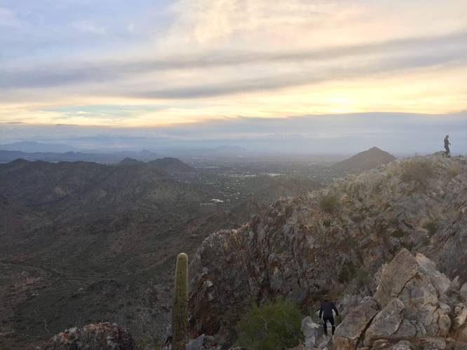
Summit: The Summit of Piestewa Peak consists of jagged rock that you'll need to somewhat scale to get to the top; however, it's not very difficult. Just before the peak is where the trail becomes a bit more dangerous considering the cliff edges to the sides of the trail and the peak itself. Watch your step and take your time climbing up and down from the peak.
Views: Aside from the top of Piestewa Peak, you get views of Phoenix along almost the entire Summit Trail. There are a few benches placed along the trail as well to help with the climb and to take in the views.
Trail traffic: This trail can be very busy even in the early morning on weekdays.
Parking: The parking coordinates provided will bring you to the Summit Trail, but this recording started off at the end of East Piestewa Peak Drive, so you can pick and choose where you want to park. As of January 2019, there's construction going on at the main Summit Trail parking lot, so parking can be found along the road.
Pets: Dogs are not allowed on this trail.
This recording starts off at the end of East Piestewa Peak Drive and follows the Freedom Trail, aka the Circumference Trail (302), for a half mile before reaching the Summit Trail (300). You can completely skip the Freedom Trail segment if you plan to just hike straight up the Summit Trail, as it'll be a slightly shorter hike.
Once you reach the Summit Trail the hike becomes almost all uphill until you reach Piestewa Peak. The trail itself consists of what feels like an endless supply of rock steps as you make your way up the 1,200 foot ascent.
Just before the last climb to the summit is a trail junction - stay right at the junction to stay on the Summit Trail.
Summit: The Summit of Piestewa Peak consists of jagged rock that you'll need to somewhat scale to get to the top; however, it's not very difficult. Just before the peak is where the trail becomes a bit more dangerous considering the cliff edges to the sides of the trail and the peak itself. Watch your step and take your time climbing up and down from the peak.
Views: Aside from the top of Piestewa Peak, you get views of Phoenix along almost the entire Summit Trail. There are a few benches placed along the trail as well to help with the climb and to take in the views.
Trail traffic: This trail can be very busy even in the early morning on weekdays.
Parking: The parking coordinates provided will bring you to the Summit Trail, but this recording started off at the end of East Piestewa Peak Drive, so you can pick and choose where you want to park. As of January 2019, there's construction going on at the main Summit Trail parking lot, so parking can be found along the road.
Pets: Dogs are not allowed on this trail.