Loading...

Picture Lake Path

Directions
Map
Pictures
Send to App
Distance:
0.4 Miles / 0.6 km
Type:
Loop
Difficulty:
Easy
Time to Hike:
~12 minutes
Features:
Surface Type:
Universal Access
Park:
Mt. Baker-Snoqualmie National Forest
Town:
Glacier, Washington
Directions:
48.866334, -121.6769
Added:
June 21, 2025
Updated:
July 11, 2025
Copy Trail Link Hiking this trail? Send a friend or family member a link to this trail guide for your own safety. Hike at your own risk (disclaimer)
Loading...
Loading...
4'

Total Change
4'

Ascent
4'

Descent

Download the Trail Route for Offline Use

Supporters get exclusive access to download trail routes to the MyHikes app for offline use. Stay prepared on your adventure, even without an internet connection! Become a Supporter today to unlock this feature and hike with confidence.

Send to App

Picture Lake Path

The Picture Lake Path at Mt. Baker National Forest near Glacier, Washington is an easy, universally-accessible trail that loops around Picture Lake and features views of the alpine mountains around Mt. Baker.

Explore Picture Lake

Starting on the northern shore of the lake, visitors will find a universally-accessible trail that runs alongside the water's edge. View of Picture Lake and the surrounding alpine landscape can be found at the trailhead and they last for the entire walk, making this one of the best short trails that the Heather Meadows section of Mt. Baker has to offer.

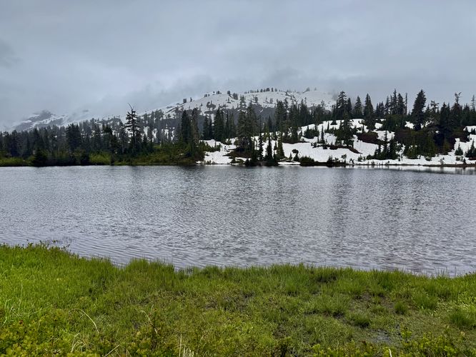
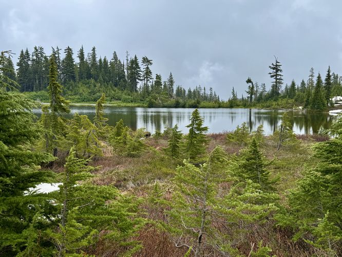
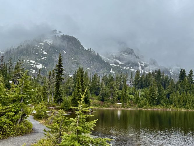
Along the western side of Picture Lake are views to the east with the water in the foreground and the ski hills of the Mt. Baker Ski Area in the background. As the trail circles the lake to the south, you'll find more hill and water views. On the eastern side of the lake, you'll find the best views of the towering alpine mountains, including Mt. Baker, on a clear day, as the path leads visitors back toward the Mt. Baker Highway.

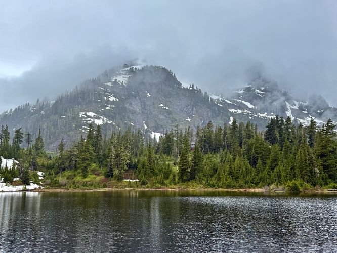
At mile 0.3, the trail technically ends at the Mt. Baker Highway, but here you can follow the side of the road back to parking. Along the road are probably the best views of Picture Lake with the alpine slopes of Mount Herman overhead. The walk ends back at the parking turnout for a short and easy 0.4-mile jaunt around Picture Lake.

Universal Access

Note that this trail is comprised of crushed gravel, boardwalks, and sections of pavement. The trail is virtually flat throughout the entire walk with minimal elevation change, is flat, and has no tripping hazards. This trail should be considered universally accessible. Note that the parking turnout near the trailhead may or may not be universally-accessible. As of June 2025, there are no handicapped parking spots, but for eager visitors that need to use a wheelchair you may be able to hop on the trail without much issue.

Parking

Visitors will find a parking turnout near the trailhead, located on the south side of the Mt. Baker Highway. The turnout is large enough to fit about a dozen vehicles as of June 2025.

Pets

Dogs are allowed only if leashed and must be cleaned up after.

Seasonal Road Closures

The Mt. Baker Highway is subject to seasonal road closures. Before heading out, make sure you check current road statuses which can be found https://www.fs.usda.gov/r06/mbs/alerts
Explore 15 trails near Glacier, WA
  1. Parking

    48.866334, -121.6769
  2. Main Trailhead

    48.86623, -121.676651
  3. View of Picture Lake and ski hills to the south

    48.866194, -121.677331
    View of Picture Lake and ski hills to the south
  4. East-facing view of Picture Lake

    48.865414, -121.678642
    East-facing view of Picture Lake
  5. Alpine views from Picture Lake

    48.864911, -121.6763
    Alpine views from Picture Lake
  6. Alpine views from the eastern shore of Picture Lake

    48.865581, -121.676231
    Alpine views from the eastern shore of Picture Lake
No community routes found. To add your own hike as a Community Route for this Trail guide, leave a Trip Report with an attached GPX file.

Seasons

All

Trip Reports

Trail Guide By:
Admin user profile picture
0.4 miles / 0.6 km
Preview of the MyHikes mobile app interface

Track, Log, and Explore Hikes with the MyHikes App

Shop Landscape Prints
Shop our Washington State landscape prints

Weather Forecast

In Glacier, WA

Explore Hiking Trails

You May Also Like

Colorado's Million Dollar Highway - Plan a day's drive adventure along the iconic Million Dollar Highway in Colorado. Explore the best short trails, roadside stops, waterfalls, vistas, ghost towns, and hot springs within a ~6 hour road trip.
Explore

Colorado's Million Dollar Highway

Plan a day's drive adventure along the iconic Million Dollar Highway in Colorado. Explore the best short trails, roadside stops, waterfalls, vistas, ghost towns, and hot springs within a ~6 hour road trip.

Read
Glacier's Going-to-the-Sun Road - Discover the breathtaking beauty of Glacier National Park along the iconic Going-to-the-Sun Road. From stunning roadside stops to picturesque waterfalls and vistas, this engineering marvel offers endless opportunities for exploration.
Explore

Glacier's Going-to-the-Sun Road

Discover the breathtaking beauty of Glacier National Park along the iconic Going-to-the-Sun Road. From stunning roadside stops to picturesque waterfalls and vistas, this engineering marvel offers endless opportunities for exploration.

Read
New York's Best Waterfalls - Whether you're planning a day hike, roadside stop, or a leisurely short walk, this guide provides hikers, travelers, and locals alike with 63 different locations to over 100 scenic waterfalls to help plan your next adventure!
Explore

New York's Best Waterfalls

Whether you're planning a day hike, roadside stop, or a leisurely short walk, this guide provides hikers, travelers, and locals alike with 63 different locations to over 100 scenic waterfalls to help plan your next adventure!

Read

Before you boogie...

Find our trail guides useful? Consider becoming a Supporter to unlock perks!

MyHikes is an indie platform that makes exploring public trails easier for everyone. The platform has no investors, no ads, and is owned and operated by one person, Dave Miller. Dave has personally mapped and written over 1,800 trail guides on MyHikes for the public to explore. MyHikes has helped millions outdoor enthusiasts plan their next adventure.

But it takes a lot of time ๐Ÿ•ฆ, money ๐Ÿ’ฐ, work, and espresso shots โ˜• to run MyHikes, including hiking , mapping , writing , and publishing new trails with high-quality (accurate) information... along with software engineering (coding) the platform like building new features, website and mobile app development (iOS and Android), site maintainance . and much much more.

Supporters unlock website and mobile app perks with an annual one-time payment of $25 (you renew) ๐Ÿ˜Ž๐Ÿ‘. Or you can simply make a Donation of your choice. Otherwise, you can support us by telling your friends about MyHikes - both quick and free ๐ŸŽ‰

Admin user profile picture

Dave Miller
MyHikes Founder