Loading...

🎆 50% off 4th of July sale on Supporter Accounts — now through July 6! Learn More.

Petar's View

Directions
Map
Pictures
Send to App
Distance:
0.1 Miles / 0.2 km
Type:
Out-and-Back
Difficulty:
Easy
Time to Hike:
~5 minutes
Features:
Surface Type:
Dirt
Park:
Garret Mountain Reservation
Town:
Paterson, New Jersey
Directions:
40.903133, -74.174403
Added:
December 15, 2023
Updated:
December 21, 2023
Copy Trail Link Hiking this trail? Send a friend or family member a link to this trail guide for your own safety. Hike at your own risk (disclaimer)
Loading...
Loading...
14'

Total Change
19'

Ascent
19'

Descent

Download the Trail Route for Offline Use

Supporters get exclusive access to download trail routes to the MyHikes app for offline use. Stay prepared on your adventure, even without an internet connection! Become a Supporter today to unlock this feature and hike with confidence.

Send to App

Petar's View

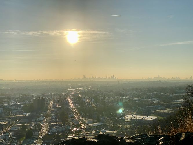
Petar's View at Garret Mountain Reservation in Paterson, New Jersey is an easy 0.1-mile out-and-back walk that features cliff views of New York City skyline and the Greater Paterson Area.

This is not a hike but rather a short walk through the woods. The trailhead can be found on the eastern side of the parking lot, at the parking coordinates provided. There are no trail signs but rather a discrete path that leads into the woods. After hopping on the trail, you'll want to take an immediate right-hand turn followed by an immediate left-hand turn. After the two turns, walkers will head straight out to the edge of Garret Mountain cliff where you'll find Petar's View. At Petar's View, you'll get 180-degree views of the Greater Paterson Area along with distant skyline views of New York City.

Parking
Visitors will find a small parking lot at the coordinates provided, located just off of the entrance / loop road at Garret Mountain Reservation. The lot, as of December 2023, is large enough to fit just under 1 dozen vehicles.

Pets
Dogs are allowed only if leashed and must be cleaned up after.

Warning
Cliffs: Watch your step by the cliff's edge.
Explore 8 trails near Paterson, NJ
  1. Parking

    40.903133, -74.174403
  2. Main Trailhead

    40.903152, -74.174379
  3. Petar's View (NYC skyline in the distance)

    40.902814, -74.1735
    Petar's View (NYC skyline in the distance)
No community routes found. To add your own hike as a Community Route for this Trail guide, leave a Trip Report with an attached GPX file.

Hazards

Ticks - Lyme Disease More Info (CDC)
Poison Ivy/Oak
Rockfalls / Ledges / or Scrambles

Seasons

All

Photo Albums

Trip Reports

Trail Guide By:
Admin user profile picture
0.1 miles / 0.2 km

Weather Forecast

In Paterson, NJ

Explore Hiking Trails

You May Also Like

Colorado's Million Dollar Highway - Plan a day's drive adventure along the iconic Million Dollar Highway in Colorado. Explore the best short trails, roadside stops, waterfalls, vistas, ghost towns, and hot springs within a ~6 hour road trip.
Explore

Colorado's Million Dollar Highway

Plan a day's drive adventure along the iconic Million Dollar Highway in Colorado. Explore the best short trails, roadside stops, waterfalls, vistas, ghost towns, and hot springs within a ~6 hour road trip.

Read
Glacier's Going-to-the-Sun Road - Discover the breathtaking beauty of Glacier National Park along the iconic Going-to-the-Sun Road. From stunning roadside stops to picturesque waterfalls and vistas, this engineering marvel offers endless opportunities for exploration.
Explore

Glacier's Going-to-the-Sun Road

Discover the breathtaking beauty of Glacier National Park along the iconic Going-to-the-Sun Road. From stunning roadside stops to picturesque waterfalls and vistas, this engineering marvel offers endless opportunities for exploration.

Read
New York's Best Waterfalls - Whether you're planning a day hike, roadside stop, or a leisurely short walk, this guide provides hikers, travelers, and locals alike with 63 different locations to over 100 scenic waterfalls to help plan your next adventure!
Explore

New York's Best Waterfalls

Whether you're planning a day hike, roadside stop, or a leisurely short walk, this guide provides hikers, travelers, and locals alike with 63 different locations to over 100 scenic waterfalls to help plan your next adventure!

Read

Before you boogie...

Find our trail guides useful? Consider becoming a Supporter to unlock perks!

MyHikes is an indie platform that makes exploring public trails easier for everyone. The platform has no investors, no ads, and is owned and operated by one person, Dave Miller. Dave has personally mapped and written over 1,800 trail guides on MyHikes for the public to explore. MyHikes has helped millions outdoor enthusiasts plan their next adventure.

But it takes a lot of time 🕦, money 💰, work, and espresso shots ☕ to run MyHikes, including hiking , mapping , writing , and publishing new trails with high-quality (accurate) information... along with software engineering (coding) the platform like building new features, website and mobile app development (iOS and Android), site maintainance . and much much more.

Supporters unlock website and mobile app perks with an annual one-time payment of $25 (you renew) 😎👍. Or you can simply make a Donation of your choice. Otherwise, you can support us by telling your friends about MyHikes - both quick and free 🎉

Admin user profile picture

Dave Miller
MyHikes Founder