Peck's Falls Trail at Greylock Glen in Adams, Massachusetts is an easy 0.2-mile out-and-back trail that leads to the 10-foot tall waterfall, Peck's Falls.
Trails
This hike follows one named trail: Peck's Falls Trail (blue blazes).
Hike Description
This short hike begins along the western side of Gould Road in Adams, MA and follows the Peck's Falls Trail as it leads downhill toward Pecks Brook and the waterfall. The trail is easy to follow and adorns blue blazes on the trees for navigation markers. The trail leads to the very-top of Peck's Falls, which is impossible to miss.
Top of Peck's Falls - Mile 0.07
Hikers will reach the top of Peck's Falls around mile 0.07 (less than 400-feet down the trail). From the top of the waterfall, hikers will get a scenic view of Peck's Falls and the brook that it cascades into.
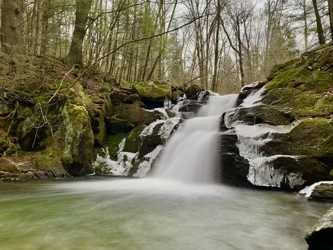
Base of Peck's Falls, approx. 10-feet tall - Mile 0.11
Hikers can then head down a series of stairs to reach the base of the 10-foot tall Peck's Falls, where the trail ends at mile 0.11. Here, you can take in the views of the short but scenic Peck's Falls. On our hike here in late December 2023, we found rose petals and baby's breath flowers lining the stairs to reach the waterfall -- likely a proposal, which was a neat Christmasy find for us non-associated hikers. This is obviously a memorable place for people to relax and enjoy the scenery. After taking in the sights of the 10-foot tall Peck's Falls, hikers will head out along the same trail you hiked-in on for a 0.2-mile out-and-back hike.
Parking
Hikers will find a parking turnout along the east side of Gould Road in Adams, MA located at the parking coordinates provided. The turnout is large enough to fit a handful of vehicles or more as of December 2023. You will have to walk down the road, headed eastward, to reach the trailhead.
Pets
Dogs are allowed only if leashed and must be cleaned up after.
Trails
This hike follows one named trail: Peck's Falls Trail (blue blazes).
Hike Description
This short hike begins along the western side of Gould Road in Adams, MA and follows the Peck's Falls Trail as it leads downhill toward Pecks Brook and the waterfall. The trail is easy to follow and adorns blue blazes on the trees for navigation markers. The trail leads to the very-top of Peck's Falls, which is impossible to miss.
Top of Peck's Falls - Mile 0.07
Hikers will reach the top of Peck's Falls around mile 0.07 (less than 400-feet down the trail). From the top of the waterfall, hikers will get a scenic view of Peck's Falls and the brook that it cascades into.
Base of Peck's Falls, approx. 10-feet tall - Mile 0.11
Hikers can then head down a series of stairs to reach the base of the 10-foot tall Peck's Falls, where the trail ends at mile 0.11. Here, you can take in the views of the short but scenic Peck's Falls. On our hike here in late December 2023, we found rose petals and baby's breath flowers lining the stairs to reach the waterfall -- likely a proposal, which was a neat Christmasy find for us non-associated hikers. This is obviously a memorable place for people to relax and enjoy the scenery. After taking in the sights of the 10-foot tall Peck's Falls, hikers will head out along the same trail you hiked-in on for a 0.2-mile out-and-back hike.
Parking
Hikers will find a parking turnout along the east side of Gould Road in Adams, MA located at the parking coordinates provided. The turnout is large enough to fit a handful of vehicles or more as of December 2023. You will have to walk down the road, headed eastward, to reach the trailhead.
Pets
Dogs are allowed only if leashed and must be cleaned up after.