This link has additional information about the Peaks of Otter area and about halfway down has an interesting story about a WW2 B25 Mitchell Bomber that crashed into Sharp Top Mountain in 1943. We were able to find the B25 but out of respect to the airmen who died we will not publish directions/coordinates to the wreck site.
The views at the top of Sharp Top and Flat Top are unbelievable. Sharp Top is very popular and can get quite crowded due to its’ proximity to the Lodge and the Blue Ridge Parkway (BRP). In contrast, you will probably run into very few hikers on Flat Top. This would be a great place to spend the weekend either at the Lodge or the nearby Campground.
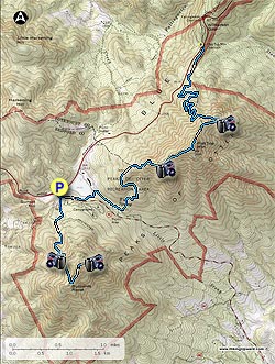
Note: Both hikes are out and back with the trails unblazed.
Sharp Top Hike: We parked and began the hike at the Peaks of Otter Visitor Center and crossed the BRP staying on the sidewalk for about 200 yards and then took a right across Route 43 heading to the Sharp Top parking area (you could also park here). Just after crossing Route 43 there is an intersection on the left that leads to the Lake Trail. You will use this route later if you decide to do the Flat Top hike. Stay on the sidewalk and the trail head is to the left of the Camp Store. The trail is un-blazed but is well worn.
For such a short trail to the peak, it will give you quite a workout with multiple series of steps throughout the hike. From the trail-head to the first good overlook is about 1 mile. Continue on the trail for about .3 of a mile and you will reach the Buzzard’s Roost Trail intersection. Bear left and go about 0.2 miles to the top (we did not go to Buzzard’s Roost but it is supposed to also have good views). There is a stone cottage at the peak. The summit offers an impressive 360-degree view of the Peaks of Otter area, The Piedmont to the East, and the Shenandoah Valley with the Allegheny Valley Mountains to the west. Retrace your steps to return to the Visitor Center for lunch/bathroom break or take a right at the Lake Trail to head towards the Flat Top trail head.
Flat Top Hike: From the Visitor Center cross back across the BRP and then Route 43 taking a left at the intersection with the sign to the Lake Trail. Go about 0.1 miles and take a left crossing Route 43 again heading towards the lake. Continue on the trail ignoring the next intersection, bear to the right at the next one heading across the earthen dam of Abbot Lake. At the end of the dam take a right going past Polly Wood’s Ordinary. The path ends up on an asphalt road which you will stay on for 0.3 mile until you reach the Falling Water/Flat Top trail head on the left (you could park here to save some time).
The next 1.4 miles is a constant up with not many switchbacks until you reach the first overlooks. You will pass through thickets of Mountain Laurel that will be absolutely beautiful when they bloom in the Spring. In another 0.6 miles you will come to the spur trail on the right for the Flat Top peak and some great views towards Bedford and the Bedford reservoir. If you know your WW2 history, Bedford lost 19 young men during the 1st phase of the D-Day landings in Normandy, more than any other city in the U.S.A. of a comparable size. A D-Day Memorial was established in 2001 in Bedford to commemorate this sacrifice.
The Flat Top Peak is the turn-around point of the hike unless you brought 2 cars and left one at the Flat Top Parking area in between BRP MP84 and MP83. From the Spur Trail take a left onto the Flat Top Trail and retrace your steps to return to the Visitor Center.
Continuation Route: From the Spur Trail take a right onto the Flat Top Trail, staying on the trail to the Flat Top Parking Area. There are a couple more overlooks, one called The Pinnacle and one called Cross Rock. Neither is as dramatic as the Flat Top peak but they are good. There are lots of switch backs on this part of the trail with the final leg being quite straight to the Parking area. This was a pleasant alternative route to the described out and back. My wife was gracious enough to meet me at the Flat Top parking area after hiking Sharp Top earlier in the day.