Loading...

๐ŸŽ‰ Enjoy a Free 7-Day Supporter Trial and Unlock Exclusive Perks โ€” No Credit Card Required. Learn more.

Peaked Mountain

Directions
Map
Pictures
Send to App
Distance:
2.0 Miles / 3.2 km
Type:
Loop
Difficulty:
Moderate
Time to Hike:
1 hour
Features:
Surface Type:
Dirt
Park:
Peaked Mountain Park
Town:
Monson, Massachusetts
Directions:
42.049589, -72.351865
Added:
August 09, 2018
Updated:
December 17, 2021
Copy Trail Link Hiking this trail? Send a friend or family member a link to this trail guide for your own safety. Hike at your own risk (disclaimer)
Loading...
Loading...
448'

Total Change
485'

Ascent
483'

Descent

Download the Trail Route for Offline Use

Supporters get exclusive access to download trail routes to the MyHikes app for offline use. Stay prepared on your adventure, even without an internet connection! Become a Supporter today to unlock this feature and hike with confidence.

Send to App

Peaked Mountain

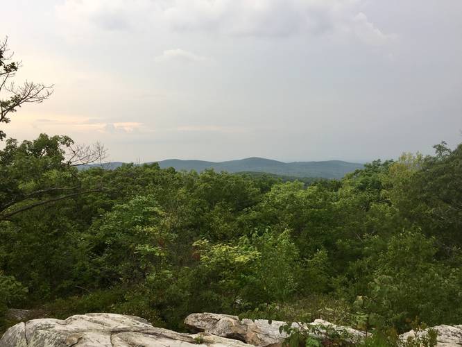
Peaked Mountain in Monson, Massachusetts is a moderate 2 mile loop hike up to the summit of Peaked Mountain with amazing views of the surrounding hills and mountains. From the summit you can also see into the state of Connecticut.

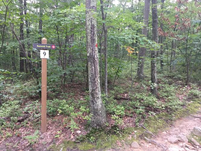
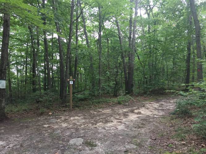
This hike starts off at the parking lot for Peaked Mountain and follows Roslyn's Turnpike Trail all the way up the mountain. This recording heads left along the Bernie Ave Trail when you reach Junction #7 (red blazes) and continues to the right at Junction #8. Shortly after you'll reach the Summit Trail at Junction #9 which leads out to the lookout points.

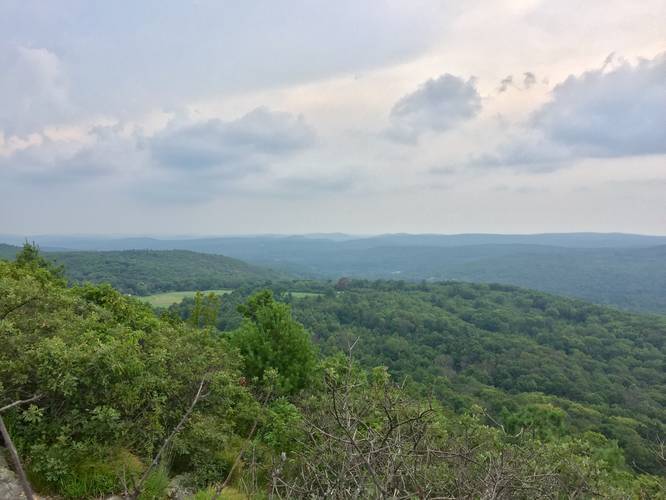
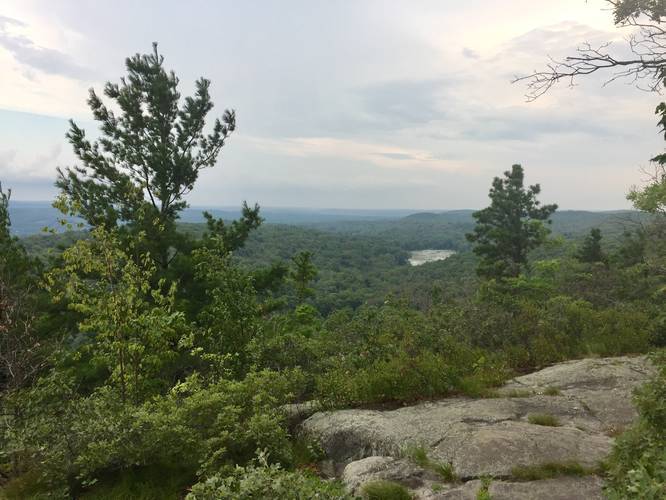
From the summit you'll hike along a rocky trail that leads downhill to a few other lookout points before the trail heads back into the woods along the Valley View Trail. At mile 1.2 you'll reach the Valley View overlook with western and northern views of the area.

Hike for another 0.3 miles until you reach junction #7 again - take the Rosyln's Turnpike Trail back to parking to complete the 2 mile hike.
Explore 182 trails near Monson, MA
  1. Parking

    42.049589, -72.351865
  2. Main Trailhead

    42.049585, -72.351378
  3. Junction #9 to the Summit Trail

    42.048856, -72.341294
    Junction #9 to the Summit Trail
  4. View from the summit of Peaked Mountain

    42.047439, -72.339981
    View from the summit of Peaked Mountain
  5. Lookout south of summit

    42.046519, -72.340081
    Lookout south of summit
  6. Junction #8 - stay right

    42.051086, -72.342278
    Junction #8 - stay right
  7. Valley View lookout point

    42.045986, -72.343308
    Valley View lookout point
  8. Fire Pond

    42.049769, -72.347206
    Fire Pond
Explore other routes for this Trail guide, added by the MyHikes' community via Trip Reports. To add your own hike as a Community Route for this Trail guide, leave a Trip Report with an attached GPX file.

Hazards

Ticks - Lyme Disease More Info (CDC)

Seasons

All

Blaze Color

Red

Trip Reports

Trail Guide By:
Admin user profile picture
2.0 miles / 3.2 km
2.0 miles / 3.2 km
July 05, 2019
This trip included taking the Fire Pond Loop on the way back down.
Hiking

Weather Forecast

In Monson, MA

Explore Hiking Trails

You May Also Like

Colorado's Million Dollar Highway - Plan a day's drive adventure along the iconic Million Dollar Highway in Colorado. Explore the best short trails, roadside stops, waterfalls, vistas, ghost towns, and hot springs within a ~6 hour road trip.
Explore

Colorado's Million Dollar Highway

Plan a day's drive adventure along the iconic Million Dollar Highway in Colorado. Explore the best short trails, roadside stops, waterfalls, vistas, ghost towns, and hot springs within a ~6 hour road trip.

Read
Glacier's Going-to-the-Sun Road - Discover the breathtaking beauty of Glacier National Park along the iconic Going-to-the-Sun Road. From stunning roadside stops to picturesque waterfalls and vistas, this engineering marvel offers endless opportunities for exploration.
Explore

Glacier's Going-to-the-Sun Road

Discover the breathtaking beauty of Glacier National Park along the iconic Going-to-the-Sun Road. From stunning roadside stops to picturesque waterfalls and vistas, this engineering marvel offers endless opportunities for exploration.

Read
New York's Best Waterfalls - Whether you're planning a day hike, roadside stop, or a leisurely short walk, this guide provides hikers, travelers, and locals alike with 63 different locations to over 100 scenic waterfalls to help plan your next adventure!
Explore

New York's Best Waterfalls

Whether you're planning a day hike, roadside stop, or a leisurely short walk, this guide provides hikers, travelers, and locals alike with 63 different locations to over 100 scenic waterfalls to help plan your next adventure!

Read

Before you boogie...

Find our trail guides useful? Consider becoming a Supporter to unlock perks!

MyHikes is an indie platform that makes exploring public trails easier for everyone. The platform has no investors, no ads, and is owned and operated by one person, Dave Miller. Dave has personally mapped and written over 1,800 trail guides on MyHikes for the public to explore. MyHikes has helped millions outdoor enthusiasts plan their next adventure.

But it takes a lot of time ๐Ÿ•ฆ, money ๐Ÿ’ฐ, work, and espresso shots โ˜• to run MyHikes, including hiking , mapping , writing , and publishing new trails with high-quality (accurate) information... along with software engineering (coding) the platform like building new features, website and mobile app development (iOS and Android), site maintainance . and much much more.

Supporters unlock website and mobile app perks with an annual one-time payment of $25 (you renew) ๐Ÿ˜Ž๐Ÿ‘. Or you can simply make a Donation of your choice. Otherwise, you can support us by telling your friends about MyHikes - both quick and free ๐ŸŽ‰

Admin user profile picture

Dave Miller
MyHikes Founder