Loading...

❄️ WINTER SALE! 50% OFF on Supporter Accounts — now through January 31st. Unlock a full year of exclusive website & app perks. Learn More.

Peak Mountain via Metacomet Trail

The Peak Mountain via Metacomet Trail in East Granby, Connecticut is a moderate 2.2-mile out-and-back hike that features beautiful vistas from the summit of Peak Mountain.

This hike starts out near the intersection of Turkey Hills Road and Newgate Road in East Granby, Connecticut and follows the Metacomet Trail north for approximately 1.1-miles before reaching the summit of Peak Mountain.

The trail begins with a steep uphill climb - during wetter months or after it rains, the trail can be very muddy and slippery while heading uphill so watch your step. After the initial climb, the trail levels out more with easy hiking towards the overlook.

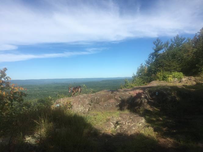
Before hikers reach the overlook, there's one more steep and rocky climb, which small dogs or children may have difficulty with. Just beyond the last uphill climb is the overlook at the summit of Peak Mountain. Hikers can take in the views before heading back down to parking for a 2.2-mile out-and-back hike.

Pets: Dogs are allowed if leashed and their waste must be carried out by the hiker.

Biking: Biking is allowed on this trail.

Parking: Parking can be found next to the trailhead along the side of Newgate Road.
Explore 128 trails near East Granby, CT

Know Before You Go

  • Peak Mountain Trail is a 2.2-mile moderate hike in East Granby, CT offering scenic vistas.
  • The Metacomet Trail starts with a steep, potentially slippery climb, followed by easier terrain with a final rocky ascent to the summit.
  • Dogs (leashed with waste carried out) and bikes are permitted; parking is available along Newgate Road.
Interactive topographic map for Peak Mountain via Metacomet Trail located in East Granby, CT. Click the "View Map" button to load GPS coordinates and trail markers.
Get directions
Distance
2.2 mi
Difficulty
Moderate
Type
Out-and-Back
Est. Time
1.1 hrs
Elev. Gain
387'
Rating
0.0
Added
September 05, 2019
Updated
September 06, 2019

Weather Forecast

Loading...
Total Change
373'
Ascent
387'
Descent
387'
Loading...

Download the GPX Data for Offline Use

Supporters get exclusive access to download trail routes to the MyHikes app for offline use. Stay prepared on your adventure, even without an internet connection! Become a Supporter today to unlock this feature and hike with confidence.

Download Peak Mountain via Metacomet Trail GPX Data to the MyHikes Mobile App

Features

Vista / Lookout Point
Dogs
Biking

Points of interest

  1. Parking

    41.947269, -72.739928
  2. Main Trailhead

    41.94724, -72.739901

Safety information

For your own safety: plan ahead, let someone know where you'll be, and hike at your own risk.

Markers

Blaze Color

Blue

Availability

All seasons

Surface type

Dirt

Trip Reports (Reviews)

Your opinion matters! Be the first to rate this trail.

Ready to help fellow hikers? Add a trip report to share your experience and provide valuable insights for other hikers!

2.2 miles / 3.5 km
September 06, 2019
This trail is just a little over a mile to the outlook with a very steep incline to start and a very rocky incline to end and get to the final outloook. Other that the very beginning and the very end, it's a very relaxed and easy hike. Dogs are absolutely allowed, small dogs may have trouble with the rocks at the end by the outlook. If there has been several day of rain, the very beginning incline can be very slippery and hard to climb. Parking is very easy, recently the town just added a whole extra lane to park, the only problem is when people don't pull straight in, there may be minimal parking; it's a rather popular trail though so you can continue to park down the street and people are very respectful.
Hiking
No community routes found. To add your own hike as a Community Route for this Trail guide, leave a Trip Report with an attached GPX file.

Popular categories

Scenic mountain view representing vista trails
Vista trails
Scenic gorge of cascades representing waterfall trails
Waterfall hikes
Rugged mountain terrain representing summit trails
Summit trails
Scenic mountain view representing dog-friendly trails
Dog-friendly
Scenic campsite with a view representing camping trails
Camping trails
Appalachian Trail logo representing A.T. hikes
A.T. hikes

You May Also Like

Colorado's Million Dollar Highway - Plan a day's drive adventure along the iconic Million Dollar Highway in Colorado. Explore the best short trails, roadside stops, waterfalls, vistas, ghost towns, and hot springs within a ~6 hour road trip.
Explore

Colorado's Million Dollar Highway

Plan a day's drive adventure along the iconic Million Dollar Highway in Colorado. Explore the best short trails, roadside stops, waterfalls, vistas, ghost towns, and hot springs within a ~6 hour road trip.

Read
Glacier's Going-to-the-Sun Road - Discover the breathtaking beauty of Glacier National Park along the iconic Going-to-the-Sun Road. From stunning roadside stops to picturesque waterfalls and vistas, this engineering marvel offers endless opportunities for exploration.
Explore

Glacier's Going-to-the-Sun Road

Discover the breathtaking beauty of Glacier National Park along the iconic Going-to-the-Sun Road. From stunning roadside stops to picturesque waterfalls and vistas, this engineering marvel offers endless opportunities for exploration.

Read
🍪 We use cookies to learn about site usage and to serve map tiles. You may block cookies manually in the browser. By continuing you agree. Learn more