Loading...

WINTER SALE! 50% OFF Supporter Accounts — now through January 31st. Learn More.

Overall Run and Beecher Ridge Hike

The Overall Run circuit passes one of the largest continuous waterfalls in Virginia. The trails also go through picturesque valley streams and meadows making this one of the prettiest hikes in the norther SNP. Also, with Beecher Ridge having one of the highest concentrations of Black Bears in the park, this is one hike where you are most likely to catch a glimpse of a black bear in the wild. If you wish to add some more length, and also catch another small pool with waterfall try the sister hike that enters the park from Chrisman Road VA697, Overall Run/Heiskell Hollow.

Flora - by Julie Ables Chapin
Along this hike in March - June are many opportunities to see native Rue-anemone (Thalictrum thalictroides), a delicate woodland perennial rising to 9 inches. At the top of the stalk is a lacy whorl of 3-parted, dark-green leaves above which rises delicate, reddish-brown stems bearing pink or white blossoms. This slender spring flower is easily cultivated in wildflower gardens and does well in part shade. Unfortunately, equally prevalent is the invasive non-native garlic mustard (Alliaria petiolata) plant, a known toxic decoy to the West Virginia white (Pieris virginiensis) butterfly, a delicate and rare spring-flying butterfly native to the region. Garlic mustardspreads rapidly in wooded areas, smothering native wildflowers, and native tree and shrub seedlings. It can overrun a forest floor in a few years, destroying a previously healthy ecosystem by eliminating many plant species.

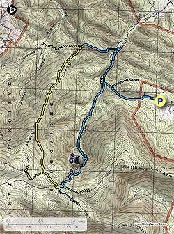
  • Mile 0.0 - From the parking area, walk down the private gravel road following the blue blazes for 0.2 miles where you pass a cable gate. After passing the cable gate continue for 200 yards where the private road you are on crosses a small creek. Turn right onto the blue blazed Thompson Hollow Trail. DO NOT continue upwards towards the house, this is all private property, please stay on the trail.
  • Mile 0.3 - Head uphill on the blue blazed trail and shortly pass a marker designating the Shenandoah National Park boundary. In 0.5 miles from the park boundary, and just past the trail high point, reach the intersection of the blue blazed Tuscarora Trail. Continue straight on the blue blazed trail for an additional 0.2 miles to the intersection of the blue blazed Overall Run/Tuscarora Trail.
  • Mile 1.0 - Turn left uphill and cross Overall Run in 0.7 miles. Cross Overall Run again in another 0.2 miles, then the trail starts getting steeper as it climbs towards Mathews Arm. The trail will become very steep with several switchbacks, then passes a small campsite 0.8 miles from the last crossing over Overall Run. From the campsite continue uphill for another 0.3 miles and arrive at the main Overall Run waterfall overlook with spectacular view of the Massanutten Range to the west. From the overlook continue uphill for 0.3 miles passing a smaller set of falls before arriving at the next trail marker. The trail to the left is the no longer maintained portion of the Mathews Arm Trail. Continue uphill on the blue blazed trail for 150 yards to the trail marker and intersection of the yellow blazed Mathews Arm Trail.
  • Mile 3.4 - Turn right on the yellow blazed Mathews Arm Trail (the yellow blazes may not be visible from the intersection), and shortly cross the top section of Overall Run. In 0.5 miles arrive a the junction of the Beecher Ridge Trail.
  • Mile 3.9 - Turn right downhill on the yellow blazed Beecher Ridge Trail as is winds its way for 2.3 miles to the intersection of the blue blazed Beecher Ridge/Overall Run connector Trail.
  • Mile 6.2 - Continue straight on the now blue blazed trail as it heads down to the valley and Overall Run in 0.6 miles. After crossing Overall Run the trail will continue downstream for 100 yards before turning right upstream, and becoming the Overall Run Trail. Turn right upstream on the Overall Run Trail is it follows the run on the left bank before passing a side trail in 0.5 miles. The side trail leads to Overall Run and large swimming hole, with a slide before and after it. Stay left uphill on the blue blazed trail, and in 0.1 miles arrive back at the intersection of the Tuscarora Trail.
  • Mile 7.5 - Turn left retracing your steps past the Tuscarora Trail turnoff in 0.2 miles, then continuing straight on the Thompson Hollow Trail to the SNP boundary, then gravel road back to the parking area in 0.8 miles.
  • Mile 7.9 - Arrive back at the parking area.
Explore 97 trails near Bentonville, VA

Know Before You Go

  • This 7.9-mile hike in Bentonville, VA, features Overall Run, one of Virginia's largest continuous waterfalls, and offers picturesque valley streams and meadows in Shenandoah National Park.
  • Beecher Ridge is known for its high concentration of black bears, making this hike a good opportunity for wildlife viewing.
  • The trail passes through areas impacted by invasive garlic mustard, which threatens native wildflowers and ecosystems; hikers may observe the native Rue-anemone in bloom between March and June.
Interactive topographic map for Overall Run and Beecher Ridge Hike located in Bentonville, VA. Click the "View Map" button to load GPS coordinates and trail markers.
Get directions
Distance
7.9 mi
Difficulty
Hard
Type
Loop
Est. Time
4 hrs
Elev. Gain
1,974'
Rating
3.9
Added
March 18, 2025
Updated
April 05, 2025

Weather Forecast

Overnight
Low 41°F
Mostly Cloudy
Wednesday
High 51°F
Light Rain Likely
Wednesday Night
Low 20°F
Chance Light Rain then Slight Chance Light Snow
Thursday
High 29°F
Mostly Sunny
Thursday Night
Low 14°F
Mostly Clear
Friday
High 36°F
Mostly Sunny
Friday Night
Low 25°F
Partly Cloudy
Saturday
High 43°F
Slight Chance Light Snow
Saturday Night
Low 19°F
Slight Chance Light Snow then Partly Cloudy
Sunday
High 29°F
Mostly Sunny
Sunday Night
Low 15°F
Partly Cloudy
M.L. King Jr. Day
High 35°F
Mostly Sunny
Monday Night
Low 14°F
Partly Cloudy
Tuesday
High 27°F
Sunny
Loading...
Total Change
1,628'
Ascent
1,974'
Descent
1,974'
Loading...

Download the GPX Data for Offline Use

Supporters get exclusive access to download trail routes to the MyHikes app for offline use. Stay prepared on your adventure, even without an internet connection! Become a Supporter today to unlock this feature and hike with confidence.

Download Overall Run and Beecher Ridge Hike GPX Data to the MyHikes Mobile App

Features

Vista / Lookout Point
Dogs
Waterfalls
Camping
Water Source

Points of interest

  1. Parking

    38.801935, -78.314615
  2. Main Trailhead

    38.801935, -78.314615

Safety information

For your own safety: plan ahead, let someone know where you'll be, and hike at your own risk.

Hazards

Snakes (Rattlesnakes, Copperheads, others)
Poison Ivy or Poison Oak

Availability

All seasons

Surface type

Dirt

Trip Reports (Reviews)

Rated 3.91 out of 5 based on 131 ratings.

Ready to help fellow hikers? Add a trip report to share your experience and provide valuable insights for other hikers!

By: Dan Dudis
7.9 miles / 12.7 km
June 04, 2017
This is a lovely hike, very much as described. My one note of caution would be that the Beecher Ridge trail is very narrow in places, with lots of undergrowth crowding into the trail and much of this undergrowth is poison ivy. It's impossible to walk the trail without your legs constantly brushing up against all the undergrowth, including the poison ivy. So if you do this hike, wear pants!
Legacy Review
By: AinDC
7.9 miles / 12.7 km
May 28, 2017
Great hike! First and last miles are very muddy, wear your waterproof hiking boots. Took us 5 hours including a ~10 minute stop at the pools and a ~20 minute stop at the falls overlook. Lots of May rain has the falls rushing and creek crossings full - you'll need to remove your shoes 3-4 times. (Bring watershoes if you can.) We went clockwise as suggested and while this ascent is much steeper, it's quicker and much more interesting with scenery changes than the counter-clockwise route which is a long climb up on the narrow trail in thick brush. If going clockwise as we did, the main push to falls is about 20-30 minutes of huffing and then you're done and can enjoy the long walk back. (Another reviewer - Todd - below notes the same thing and I wholeheartedly agree.) Also, we hiked with our dog and with wet rocks, the steep descent after the falls would've been a little tricky had we done the reverse route. Lots of ticks, be sure to use bug spray and check your dog thoroughly after the hike. We pulled into the gravel parking area at 10 a.m. and were the fifth car there - was much more crowded when we returned. We saw maybe 5-6 other groups. Matthews Arm campground is closed so the trails weren't too crowded for Memorial Day Weekend.
Legacy Review
By: Todd Heinz
7.9 miles / 12.7 km
February 05, 2017
I've now hiked this trail 3 times- once in the summer and twice in the winter, and I've done it twice clockwise and once counter-clockwise, every time from the bottom. I can say without hesitation that the best time is in the winter and the best direction is clockwise. Here's why- the foliage is pretty dense leading up to the views of the falls and the gorge that they fall into. In the winter your views are much less obstructed vs in the summer at points there's a wall of green. Furthermore, the water flow in winter is pretty strong, and if it's around freezing you get very cool ice formations not only on the falls but also on the areas surrounding the falls due to the freezing mist coming off the falls. But don't worry- there's been no ice on the trails when I've been there. Why clockwise is better- the approach to the steep section is very moderate and scenic as you hike along the trail, and while the steep section is pretty steep, there are a number of switchbacks, and since some sections are pretty rocky, I personally find it easier going up on rocky areas than going down them. Here's another reason- when you go counter-clockwise the yellow trail is just a continuous uphill slog and there's no views or anything of interest to see. So while counter clockwise is not nearly as steep, its constant and long...and boring and for me it was more tiring. At least the steep, clockwise way is over and done with quickly and is punctuated by awesome views of the falls and gorge. Next time I go, I plan to just do an out and back rather than the loop because the yellow trail, even when going clockwise and down hill, is so boring.
Legacy Review
No community routes found. To add your own hike as a Community Route for this Trail guide, leave a Trip Report with an attached GPX file.

Popular categories

Scenic mountain view representing vista trails
Vista trails
Scenic gorge of cascades representing waterfall trails
Waterfall hikes
Rugged mountain terrain representing summit trails
Summit trails
Scenic mountain view representing dog-friendly trails
Dog-friendly
Scenic campsite with a view representing camping trails
Camping trails
Appalachian Trail logo representing A.T. hikes
A.T. hikes

You May Also Like

25 Best Day Hikes in North Carolina - Discover the top 25 best day hikes in North Carolina, from breathtaking waterfalls to mountain peaks. Explore hidden gems, scenic views, and trails suitable for all skill levels, perfect for your next outdoor adventure.
Explore

25 Best Day Hikes in North Carolina

Discover the top 25 best day hikes in North Carolina, from breathtaking waterfalls to mountain peaks. Explore hidden gems, scenic views, and trails suitable for all skill levels, perfect for your next outdoor adventure.

Read
🍪 We use cookies to learn about site usage and to serve map tiles. You may block cookies manually in the browser. By continuing you agree. Learn more