Discover the picturesque Oseetah Lake Trail at Adirondack Park in Saranac Lake, New York, a moderate 2-mile loop hike boasting breathtaking vistas of Scarface Mountain and the serene Saranac River. Immerse yourself in the beauty of lush hemlock and red pine forests as you explore this scenic trail.
Hike
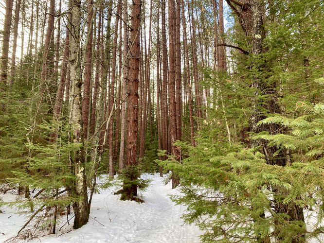
This hike begins along the western side of the Adirondack Rail Trail, located just a couple-hundred feet from its trailhead. There are two trailheads for the Oseetah Lake Trail and Southern-most trailhead is by far the most-scenic as hikers begin the trek by passing through a stunning Red Pine forest. The Red Pine grove doesn't last very long and soon hikers will find themselves on the main trail.
Loop (Keep-Left) - Mile 0.1
Around mile 0.1, hikers will reach a junction in the trail that defines the loop. Keeping left here will ensure you stay on the flatter section of the trail as it makes its way out and eventually along the Saranac River.
After keeping left at the loop junction, hikers will quickly begin to pass through scenic Eastern Hemlock forests. Be on the lookout for more red blazes that define the trail as you'll want to take a right-hand turn soon, around mile 0.4.
Right-Hand Turn - Mile 0.4
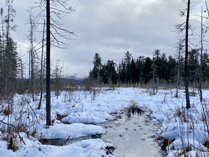
Around mile 0.4, hikers will reach another trail junction -- here, take a right-hand turn to stay on the main trail. If you accidentally take a left here, you'll hike out to a swamp. If you find yourself at the swamp, simply hike back to this junction.
After taking the turn at mile 0.4, hikers will continue weaving in and out of more Eastern Hemlock groves, including at least one that forms a scenic tree tunnel. The trail will undulate a bit as it makes its way out to the Saranac River, but for the most part the trail is relatively flat.
View of Saranac River - Mile 0.75
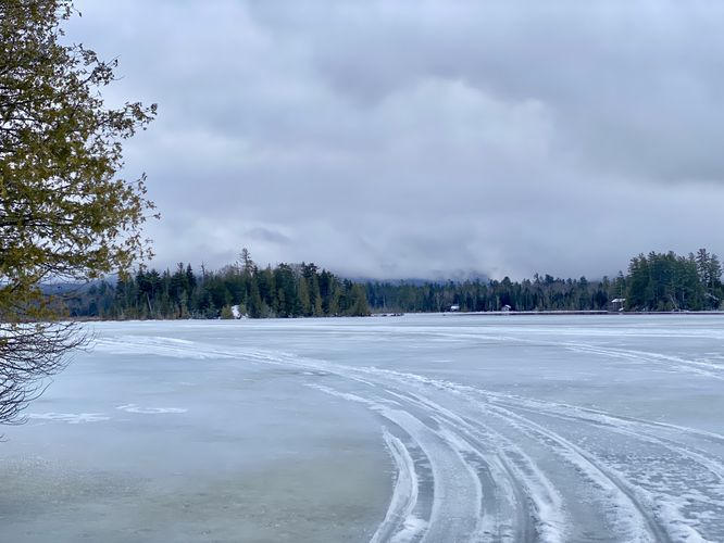
Around mile 0.75, hikers will reach the first viewpoint along the Saranac River. Here you'll be able to spot hills of Saranac Lake located across the river, houses that line its banks, and evergreens that dot the landscape. Continue onward to even better views.
View of Scarface Mountain - Mile 0.9
At the 0.9-mile mark, hikers are treated to a breathtaking panoramic vista of Scarface Mountain with the foreground of the Saranac River at your feet, making it the highlight of the trail and an ideal midway point in the loop. Consider this spot as an option to turn back if desired. For those continuing the loop, be aware that the remaining trails may be less frequented and slightly overgrown in the summer months.
Completing the Loop - Mile 0.9 to 1.65
After visiting the Scarface Mountain view along the shores of the Saranac River, hikers can complete the loop by hiking North from the view. Within a few-hundred feet, you'll find a right-hand turn. Take this right-hand turn and then take an immediate left-hand turn to follow yellow blazes as they define a trail that heads due-North. This yellow-blazed trail is less-traveled than the previous and this can be harder to follow. It heads North for quite a while before it begins to run East and up a small hill. You'll know you're on the right path if you pass an old rusty fence posting with metal wiring connecting both posts. Once at the top of the hill, you'll want to keep left to head back down the hill at a steeper grade. Do not hike into the inner loop, you might get a bit lost if you do. Eventually, the trail reaches a flatter junction at mile 1.55 -- take this right-hand turn to head East and complete the loop at mile 1.65.
After completing the loop with the trails that run along the hillside, the hike back to parking follows the well-defined Oseetah Lake Trail to end at the main parking lot.
Parking
Hikers will find a very large parking lot at the coordinates provided, located on the South side of NY-86 / Saranac-Placid Road in Saranac Lake. The lot is large enough to fit over a dozen vehicles. There's another parking lot located across the street of a similar size.
Pets
Dogs are allowed only if leashed and must be cleaned up after.
Snowmobiling
This is a popular snowmobile trail during the winter months. For this reason, be mindful of snowmobiles when out on the trails.
Parks
This trail exists within the Saranac Lakes Wild Forest within Adirondack Park. You can refer to the official Saranac Lakes Wild Forest (Scarface Mountain) trail map to help plan.
Hike
This hike begins along the western side of the Adirondack Rail Trail, located just a couple-hundred feet from its trailhead. There are two trailheads for the Oseetah Lake Trail and Southern-most trailhead is by far the most-scenic as hikers begin the trek by passing through a stunning Red Pine forest. The Red Pine grove doesn't last very long and soon hikers will find themselves on the main trail.
Loop (Keep-Left) - Mile 0.1
Around mile 0.1, hikers will reach a junction in the trail that defines the loop. Keeping left here will ensure you stay on the flatter section of the trail as it makes its way out and eventually along the Saranac River.
After keeping left at the loop junction, hikers will quickly begin to pass through scenic Eastern Hemlock forests. Be on the lookout for more red blazes that define the trail as you'll want to take a right-hand turn soon, around mile 0.4.
Right-Hand Turn - Mile 0.4
Around mile 0.4, hikers will reach another trail junction -- here, take a right-hand turn to stay on the main trail. If you accidentally take a left here, you'll hike out to a swamp. If you find yourself at the swamp, simply hike back to this junction.
After taking the turn at mile 0.4, hikers will continue weaving in and out of more Eastern Hemlock groves, including at least one that forms a scenic tree tunnel. The trail will undulate a bit as it makes its way out to the Saranac River, but for the most part the trail is relatively flat.
View of Saranac River - Mile 0.75
Around mile 0.75, hikers will reach the first viewpoint along the Saranac River. Here you'll be able to spot hills of Saranac Lake located across the river, houses that line its banks, and evergreens that dot the landscape. Continue onward to even better views.
View of Scarface Mountain - Mile 0.9
At the 0.9-mile mark, hikers are treated to a breathtaking panoramic vista of Scarface Mountain with the foreground of the Saranac River at your feet, making it the highlight of the trail and an ideal midway point in the loop. Consider this spot as an option to turn back if desired. For those continuing the loop, be aware that the remaining trails may be less frequented and slightly overgrown in the summer months.
Completing the Loop - Mile 0.9 to 1.65
After visiting the Scarface Mountain view along the shores of the Saranac River, hikers can complete the loop by hiking North from the view. Within a few-hundred feet, you'll find a right-hand turn. Take this right-hand turn and then take an immediate left-hand turn to follow yellow blazes as they define a trail that heads due-North. This yellow-blazed trail is less-traveled than the previous and this can be harder to follow. It heads North for quite a while before it begins to run East and up a small hill. You'll know you're on the right path if you pass an old rusty fence posting with metal wiring connecting both posts. Once at the top of the hill, you'll want to keep left to head back down the hill at a steeper grade. Do not hike into the inner loop, you might get a bit lost if you do. Eventually, the trail reaches a flatter junction at mile 1.55 -- take this right-hand turn to head East and complete the loop at mile 1.65.
After completing the loop with the trails that run along the hillside, the hike back to parking follows the well-defined Oseetah Lake Trail to end at the main parking lot.
Parking
Hikers will find a very large parking lot at the coordinates provided, located on the South side of NY-86 / Saranac-Placid Road in Saranac Lake. The lot is large enough to fit over a dozen vehicles. There's another parking lot located across the street of a similar size.
Pets
Dogs are allowed only if leashed and must be cleaned up after.
Snowmobiling
This is a popular snowmobile trail during the winter months. For this reason, be mindful of snowmobiles when out on the trails.
Parks
This trail exists within the Saranac Lakes Wild Forest within Adirondack Park. You can refer to the official Saranac Lakes Wild Forest (Scarface Mountain) trail map to help plan.